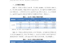
下载完整pdf文档
Technology and Innovation for the Development of Land Transport in Arab Countries VISION ESCWA, an innovative catalyst for a stable, just and flourishing Arab region. MISSION Committed to the 2030 Agenda, ESCWA’s passionate team produces innovative knowledge, fosters regional consensus and delivers transformational policy advice. Together, we work for a sustainable future for all. Economic and Social Commission for Western Asia E/ESCWA/CL4.SIT/2020/2 Technology and Innovation for the Development of Land Transport in Arab Countries © 2021 United Nations All rights reserved worldwide Photocopies and reproductions of excerpts are allowed with proper credits. All queries on rights and licenses, including subsidiary rights, should be addressed to the United Nations Economic and Social Commission for Western Asia (ESCWA), email: publications-escwa@un.org. The findings, interpretations and conclusions expressed in this publication are those of the authors and do not necessarily reflect the views of the United Nations or its officials or Member States. The designations employed and the presentation of material in this publication do not imply the expression of any opinion whatsoever on the part of the United Nations concerning the legal status of any country, territory, city or area or of its authorities, or concerning the delimitation of its frontiers or boundaries. Links contained in this publication are provided for the convenience of the reader and are correct at the time of issue. The United Nations takes no responsibility for the continued accuracy of that information or for the content of any external website. References have, wherever possible, been verified. Mention of commercial names and products does not imply the endorsement of the United Nations. References to dollars ($) are to United States dollars, unless otherwise stated. Symbols of United Nations documents are composed of capital letters combined with figures. Mention of such a symbol indicates a reference to a United Nations document. United Nations publication issued by ESCWA, United Nations House, Riad El Solh Square, P.O. Box: 11-8575, Beirut, Lebanon. Website: www.unescwa.org. 3 PREFACE The transport sector has always evolved together with the progress of technology, as innovative technological solutions have transformed and modernised it throughout the ages. The exponential technological progress witnessed today, as well as the diversity of innovative solutions that have been emerging, is expected to transform the land transport sector, and enhance its efficiency, its safety, and the mobility of people within it. The present report is in line with the ESCWA mandate pertaining to technology for development, transport and logistics, and the achievement of the Sustainable Development Goals (SDGs). Some of the most relevant resolutions in this regard are: A/RES/74/229 (Science, technology and innovation for sustainable development), A/RES/72/212 (Strengthening the links between all modes of transport to achieve the Sustainable Development Goals) and A/RES/70/1 (Transforming our world: the 2030 Agenda for Sustainable Development). This report was initiated in response to the requests made by representatives of member countries on two separate occasions. One was the second Intergovernmental Meeting on Technology for Development, held in Beirut in 2019, during which they requested that ECSWA focuses on technology and innovation for special contexts and selected sectors. Another was the 2018 round-table discussion of the Committee on Transport and Logistics, during which they highlighted the importance of technological development in the transport sector. The report seeks to demonstrate the role of digital technology in improving the land transport sector, by discussing available technologies as well as future trends that could further influence development in this sector. It highlights the status of enabling technologies and the most commonly used technological applications in the Arab region, and provides recommendations and policy frameworks to enable and facilitate the integration of new technology in land transport in Arab countries. Technology and Innovation for the Development of Land Transport in Arab Countries 4 ACKNOWLEDGMENTS The present study was prepared by the Statistics, Information Society and Technology Cluster, in cooperation with the Shared Economic Prosperity Cluster, at the Economic and Social Commission for Western Asia (ESCWA). Ms. Nibal Idlebi, Chief of Innovation Section, and Mr. Yarob Badr, Regional Advisor on Transport and Logistics, led the team comprising: Ms. Lize Denner, Associate Programme Management Officer at the Innovation Section, Ms. Hania Dimassi, Senior Research Assistant at the 2030 Agenda and SDG Coordination Cluster, Research Assistant Mr. Fouad Ghorra, Ms. Maya Hammoud, Ms. Zahira Abounoas, and Intern Mr. Michael Ammoury. This study is based on an extensive report prepared by Mr. Rami Semaan, Senior Expert inTransport, and Ms. Salam Yamout, Senior Expert in Technology. The ESCWA Team greatly acknowledges their valuable contributions. The study was discussed during a virtual Focus Group Meeting held on 1 December 2020 in Beirut, and the information and knowledge shared in discussions held during this meeting were used to enhance the content of this study. TheTeam would like to thank the external peer reviewer, Mr. Mahmoud H. Abdallat, Secretary General of the Arab Union of Land Transport (AULT), and the internal peer reviewer, Mr. Ayman El Sherbiny, Chief of Information and Communications Technology (ICT) Policy Section at ESCWA. The Team also recognises the leadership and supervision provided by Mr. Juraj Riecan, Director of the Statistics, Information Society and Technology Cluster. 5 EXECUTIVE SUMMARY This report aims to identify the role technology and innovation can play in developing the land transport sector in the Arab region.The intersection of these two sectors, transport and technology, is an important one. Indeed, throughout the ages, technology has provided innovative solutions that have transformed and modernised human transportation and the entire transport sector. The report is being published at an opportune time, when Arab leaders are looking for transport solutions that would provide social, economic and environmental benefits, while being able to satisfy fast-growing urban populations. The report thus focuses on the transformative role of technology in land transport, and examines holistically important aspects, namely infrastructure, legal and regulatory environments, human capital, the capacity for innovation, the availability of funds, services, operation and governance. The report is comprised of four chapters. “Chapter 1 - Conceptual Framework of the Transport System, and the Historical Role of Technology in the Transport Sector” examines the conceptual framework of transport systems, and the interactions between their environment and their internal elements that affect their performance. Many of the outcomes of these interactions are positive and desirable for transport systems, but there are two notable negative outcomes: namely, road accidents and environmental pollution. The chapter goes on to list the main benefits of wellperforming transport systems, dividing them into social, economic and environmental benefits. Two additional benefits are their contribution towards achieving the SDGs, and the transformative role that new technology can play in transport systems. Chapter 1 evaluates the relationship between technology and transport systems, to find that transformations in the transport sector do result from technological factors, but that the sector is also affected by changes in the ecology and climate, economic factors, and geopolitical factors, like conflicts and wars. Finally, the chapter reviews the role technology has played in transport throughout history, from the wheel and the sail to the Hyperloop train.The report divides new technology into digital technology emanating from the 4IR, and non-digital technology, such as the use of lightweight materials in the manufacturing of vehicles, Autonomous Vehicle systems and Hyperloop trains. However, while the report does mention the latter, its focus is mainly on digital technologies. “Chapter 2 – Digital Technology Solutions in Land Transport” provides a comprehensive review of technologies, software systems and applications used in the transport sector. The chapter is divided into three parts. The first describes the enabling technologies or prerequisites needed to integrate digital technology in the transport sector. These include internet connectivity, local network connectivity, internet addressing and IPv6, IoT, GPS, GIS, Cloud Computing, Big Data, and Open Data. The second part of the chapter describes software systems for the management of freight, traffic and infrastructure, and passengers. In fact, with the rapid growth of Cloud Computing, most transport applications, especially for the management of passengers, are now available on the Cloud, under “Platform as a Service”, “Software as a Service” or “Mobility as a Service”. Finally, the third part describes future technology trends, including Artificial Intelligence, Vehicle-to-Vehicle Networks and urban pods. The challenges of applying digital technology solutions include the availability of digital skills, privacy and security concerns, the availability of budgets, clear policy directives, and, last but not least, the availability of data, especially Open Data. “Chapter 3 – Status of Technology and Innovation in Land Transport in the Arab Region” represents the first attempt by ESCWA to directly explore the impacts and opportunities presented Technology and Innovation for the Development of Land Transport in Arab Countries by the rapidly developing field of modern technology in the land transport sector.The chapter’s assessment of the use of new technologies and innovations in land transport in Arab countries is rooted in the analysis of the results of detailed questionnaires that were sent to national focal points in both the transport and technology sectors. The aim of the questionnaires was to collect data about technology and innovation in land transport services. Twelve Arab countries responded, which is an adequate sample for the formulation of a general appraisal. The analysis of their responses shows that they all have a great deal of interest in improving their transport systems by implementing technological solutions. It is also clear from their responses that these countries are currently at different levels of development, with the GCC countries in the lead, and countries like Morocco and Jordan close behind. One common observation is that the financing of public transport systems relies heavily on public funds in most of these countries, and that many of the systems discussed in this report are currently in the planning phase in several of them. In conclusion, the key message from the entire report is that new digital technology is redefining transportation as we know it, with broad socio-economic implications for ordinary citizens, service providers and policy-makers alike. However, the report also highlights the fact that Arab countries have yet to experience a breakthrough in this regard, as they have so far failed to use technology and innovation as drivers of a productive economy. This means that more needs to be done at a comprehensive policy level, to create an innovation ecosystem with a practical governance mechanism. Future transport systems will likely be shaped by a new balance between the forces that maintain those systems in equilibrium. The shape of future transport will be determined by the main concerns of moving passengers and freight faster, in greater quantities, more safely and more efficiently. “Chapter 4 – Policy Framework for Mainstreaming Technology Solutions inTransport Systems” offers comprehensive policy recommendations in all areas affecting the performance of technologyenabled transport systems: flexible regulatory frameworks; securing funding for transport systems; Open Data; vibrant innovation and entrepreneurship ecosystems; reducing fuel consumption; privacy and security; ubiquitous connectivity; and standardisation and interoperability. The chapter argues that governance and coordination between the various stakeholders is key to the success of technology and innovation projects, as are flexible regulatory environments. Indeed, too many license requirements and restrictions can stifle innovation. This chapter also shows the need for human capital development, through capacitybuilding and increasing digital literacy, both for the development of new systems, and for currently used systems to be adopted by users. 7 Contents Preface 03 Acknowledgments 04 Executive Summary 05 List of Abbreviations 09 Introduction 11 1 CONCEPTUAL FRAMEWORK OF THE TRANSPORT SYSTEM, AND THE HISTORICAL ROLE OF 13 TECHNOLOGY IN THE TRANSPORT SECTOR A. Overview of the Conceptual Framework of the Transport System 14 B. The Relationship Between Technology and the Transport Sector 18 C. Emerging Technologies for Land Transport 22 D. Advantages and Benefits of Innovation and Digital Technology Applications in the 24 Transport Sector 2 DIGITAL TECHNOLOGY SOLUTIONS IN LAND TRANSPORT 27 A. Enabling Technologies for Land Transport 28 B. Technology Applications in Land Transport 40 C. Future Trends in Land Transport 47 D. Challenges to the Application of Technology Solutions 50 3 STATUS OF TECHNOLOGY AND INNOVATION IN LAND TRANSPORT IN THE ARAB REGION 53 A. Analysis of Technology Applications in Land Transport in the Arab Region 55 B. Questionnaire on Technology 65 4 POLICY FRAMEWORK FOR MAINSTREAMING TECHNOLOGY SOLUTIONS IN TRANSPORT SYSTEMS 73 A. Flexible Regulatory Frameworks 75 B. Funding for Transport Systems 76 C. Open Data and Big Data 77 D. Vibrant Innovation and Entrepreneurship Ecosystem 78 E. Reducing Fuel Consumption 79 F. Privacy and Security 80 G. Ubiquitous Connectivity 80 H. Standardisation and Interoperability 81 Conclusion 83 Endnotes 84 Bibliography 86 Technology and Innovation for the Development of Land Transport in Arab Countries 8 List of Tables Table 1. Table 2. Table 3. Table 4. Table 5. Table 6. Links Between Transport Systems and the SDGs .................................................................... 21 Rural Roads – Status by Country ................................................................................................. 56 Railways – Status of the Use of New Technology by Country .............................................. 58 Urban Streets – Status by Country.............................................................................................. 60 Public Transport – Status by Country ......................................................................................... 62 LTM Operation and Border Crossings – Status by Country ................................................... 64 List of Figures Figure 1. Schematic Illustration of the Transport System..................................................................... 15 Figure 2. Enablers of the Fourth Industrial Revolution........................................................................... 23 Figure 3. Five Technologies at the Forefront of the Transport Sector ................................................ 23 Figure 4. Internet Access Infrastructure.................................................................................................. 29 Figure 5. IoT Layered Models ..................................................................................................................... 32 Figure 6. IoT Applications in Transport ..................................................................................................... 33 Figure 7. MaaS Representation ................................................................................................................. 45 Figure 8. Uses of AI in Transportation....................................................................................................... 49 Figure 9. Rural Roads – Status by Technology........................................................................................ 55 Figure 10. Rural Roads – Percentage of New Technology Coverage by Country.............................. 56 Figure 11. Railways – Status by Technology ............................................................................................. 57 Figure 12. Railways – Percentage of New Technology Coverage by Country ................................... 58 Figure 13. Urban Streets – Use of New Technology in Arab Countries ............................................... 60 Figure 14. Urban Streets – Percentage of New Technology Coverage by Country .......................... 61 Figure 15. Public Transport – Status of Use of New Technology .......................................................... 62 Figure 16. Public Transport – Percentage of New Technology Coverage by Country...................... 63 Figure 17. LTM Operation and Border Crossings – Status by Technology .......................................... 64 Figure 18. LTM Operation and Border Crossings – Percentage of New Technology Coverage by Country........................................................................................................................................65 Figure 19. Mobile Coverage by Country ..................................................................................................... 66 Figure 20. Status of Connectivity in the Arab Region............................................................................... 67 Figure 21. Financing of Transport IT Systems by Country....................................................................... 68 Figure 22. Provenance of Transport IT Systems by Country .................................................................. 69 Figure 23. IT Systems in Land Transport in Arab Countries.................................................................... 70 Figure 24. Technology-Related Legislation by Country ........................................................................... 71 Figure 25. Number of Countries per Technology-Related Regulation .................................................. 71 Figure 26. Readiness to Implement Emerging Technologies in Land Transport................................. 72 List of Boxes Box 1. Applications of ITS in Qatar.............................................................................................................. 26 Box 2. Examples of the Application of IoT in the Transport Sector ...................................................... 34 Box 3. Boston – The MIT Big Data Challenge ........................................................................................... 35 Box 4. Dubai – GTFS ....................................................................................................................................... 39 Box 5. Paris – Electric Carsharing ............................................................................................................... 47 Box 6. KSA – Data Privacy Regulatory Framework.................................................................................. 51 9 LIST OF ABBREVIATIONS 4IR AaaS AHS AI ANN Fourth Industrial Revolution Analytics as a Service Automated Highway System Artificial Intelligence Artificial Neural Networks ANPR API AVS BLE BMS CCTV CNS CSV CVC DaaS Automatic Number-Plate Recognition Application Programming Interface Autonomous Vehicle System Bluetooth Low Energy Bus Management System Closed-Circuit Television Courier Network Service Comma-Separated Values Connected Vehicle Cloud Data as a Service DDoS DLT DMS Distributed Denial-of-Service Distributed Ledger Technology Dynamic Message Sign DSRC Dedicated Short-Range Communication EC-GSM Extended Coverage GSM EDP European Data Portal EETS ERP ERTMS ESCWA E-TIR FL FMS FTTX GCC GDP European Electronic Toll Service Electronic Road Pricing European Rail Traffic Management System Economic and Social Commission for Western Asia Electronic Transports Internationaux Routiers Fuzzy Logic Fleet Management System Fibre to the x Gulf Cooperation Council Gross Domestic Product GHG GII GIS GLONASS/ Greenhouse Gas Global Innovation Index Geographic Information System Global Navigation Satellite System GNSS GN GPRS Genetic Algorithm General Packet Radio Service GPS GSM Global Positioning System Global System for Mobile Communications GTFS HAR HGV IaaS ICT IDC IoT IP ISP IT ITS IXP KSI LMS LPWAN LTE-M LMT MaaS MENA MIS MIT ML MMS MOD NGO NB-IoT NIS NRI ODB OMS OSI OTT PaaS POS PPP QoS R&D RFID RITA RTA General Transit Feed Specification Highway Advisory Radio Heavy Goods Vehicle Infrastructure as a Service Information and Communications Technology International Data Corporation The Internet of Things Internet Protocol Internet Service Provider Information Technology Intelligent Transport System Internet Exchange Point Killed or Seriously Injured Logistics Management Systems Low Power Wide Area Network Long-Term Evolution for Machines Land Transport Management Mobility as a Service Middle East and North Africa Management Information System Massachusetts Institute of Technology Machine Learning Multimedia Messaging Service Mobility on Demand Non-Governmental Organisation Narrowband-IoT National Innovation System Networked Readiness Index Open Data Barometer Order Management Systems Open Systems Interconnection Over-The-Top media service Platform as a Service Point of Sale Public-Private Partnership Quality of Service Research and Development Radio-Frequency Identification Research and Innovative Technology Administration Road and Traffic Authority Technology and Innovation for the Development of Land Transport in Arab Countries SaaS SCOOT SDGs SITS SMC SMS TMS TNC TOPIS TRA TSI UAM VANET VMS WMS Software as a Service Split Cycle Offset Optimisation Technique Sustainable Development Goals Surface Intelligent Transport System Smart Mobility Congress Short Message Service Transportation Management System Transportation Network Company Transport Operation & Information Service Telecom Regulatory Authorities Technical Specification for Interoperability Urban Air Mobility Vehicular Ad-Hoc Network Variable Message Sign Warehouse Management System 11 INTRODUCTION Throughout the ages, technological inventions and innovations have sparked structural transformations in the performance of transport systems, as well as in the wider framework of their environment. The exponential progress in technology witnessed today, with the diversity of new technologies and innovative solutions that have been emerging, is expected to bring major changes to the land transport sector, in terms of its structure, the mobility of people and the movement of goods within it, as well as its labour force. In the Arab region, the need for such a technology-fuelled transformation is particularly relevant, for three main reasons. First, the region’s urban population is booming. According to ESCWA’s 2020 Arab Sustainable Development Report, “the urban population in the Arab region grew more than fourfold from 1970 to 2010. It will more than double from 2010 to 2050”.1 Arab countries also have the second highest annual population growth rate in the world, at 1.9 per cent. As a result, by 2050, roughly 70 per cent of the region’s population will be living in cities. Equipping Arab cities with modern transport systems, and with the infrastructure needed to enable such systems, has thus become a necessity. Unfortunately, as this report will show, many Arab cities do not have the required infrastructure, and planning for the expansion of their transport systems must therefore start immediately. Second, while the major technological trends in digitalisation are very diverse, they are at different levels of development in different countries. The Arab region in particular suffers from substantial barriers to sustainable growth in the use of technology in various sectors. ESCWA’s Horizon 2030 report states that “most Arab countries have stagnated or lowered over the period from 2010-2011 to 2016-2017”2 in terms of their ranking in two international indices, the Networked Readiness Index (NRI) and the Global Innovation Index (GII), which respectively address the digital economy and innovation. Focusing on the application of new technology in one vital sector, such as transport, would go a long way towards developing both. Third, within the context of climate change, the harmful impact of carbon dioxide emissions generated by transport systems in all cities worldwide will by 2050 result in intolerably high rates of pollution and sea level rise. Technology must be developed to reduce carbon emissions and achieve sustainable levels of development. It is thus no surprise to find innovation in transportation at the heart of the future city planned by Saudi Arabia, “NEOM – the Line”, “a city of a million residents with a length of 170 km that preserves 95 per cent of nature within NEOM, with zero cars, zero streets and zero carbon emissions.”3 This goes a step further than the ambitious Dubai “Smart City” initiative, where innovative transport systems also play a central role. Both cases demonstrate that Arab leaders are already looking to technological innovation in transport systems to achieve sustainable levels of economic and social development. However, although some countries in the region have made progress in adopting innovations and new technology in transport development, Technology and Innovation for the Development of Land Transport in Arab Countries 12 the literature review reveals that little has been published in fields connected to policy and regulation, as well as regarding the technological options available to countries. This report seeks to establish a base study on the use of technology and innovation for the development of land transport in Arab countries. It also aims to improve our knowledge of the role played by technology and innovation in modernising land transport in the Arab region. Specifically, the report aims to study: 1. The importance of the land transport sector for social development and economic growth; and the positive impact of technology and innovation on safety, efficiency, mobility and planning in land transport. 2. The role digital and emerging technologies can play in improving the land transport sector globally and in the Arab region. 3. The policy framework needed to ensure that countries benefit from new technology in the land transport sector, and to enable the use of emerging technologies in land transport in Arab countries. The target audience for this report are decisionmakers and officials in ministries and authorities working in the transport sector; ministries and institutions in charge of technology in general and Information and Communications Technology (ICT) in particular; international and regional organisations; interested scholars and researchers from academia; and professional and civil associations. Chapter 1 of the report examines the conceptual framework of transport systems, the historical and current role of technology in the transport sector, and the benefits of using technology in transport systems. Chapter 2 examines available digital and technological solutions in land transport. Chapter 3 examines the status of technology and innovation in land transport in the Arab region, using a customised survey. Chapter 4 offers policy recommendations for mainstreaming technological solutions in transport planning. 13 1 CONCEPTUAL FRAMEWORK OF THE TRANSPORT SYSTEM, AND THE HISTORICAL ROLE OF TECHNOLOGY IN THE TRANSPORT SECTOR Technology and Innovation for the Development of Land Transport in Arab Countries 14 ” Key Messages • Transport is essential for economic and social development in all countries, as well as for regional and global cooperation and economies. Its added value to global GDP ranges from 6 to 12 per cent, and transport typically provides 5 to 8 per cent of the average national total paid employment; • Many factors affect transport systems in all countries, and these include natural geography, social and economic settings, legislative environments and institutional structures, political contexts and orientations, as well as levels of technological development; • Technological applications in land transport play an important role in the management of passengers and freight, and have positive effects on the efficiency, safety, mobility and reliability of transport services; • Emerging digital technologies, such as the Internet of Things (IoT), Big Data, Open Data, Cloud Computing and Artificial Intelligence, will bring further transformations to the land transport sector, improving its management, enhancing its efficiency and safety, and reducing carbon emissions and fuel consumption. ” A. Overview of the Conceptual Framework of the Transport System Transport is essential for economic and social development in all countries, as well as for regional and global cooperation and economies. No added value can be achieved without moving a commodity from the location of its production to that of its consumption, and social development cannot be achieved without ensuring the daily movement of people for such purposes as education, work, shopping or entertainment. The value added by the transport sector to global Gross Domestic Product (GDP) ranges from 6 to 12 per cent, and transport typically provides 5 to 8 per cent of the average national total paid employment. Transport services and activities are the result of complicated interactions between many exogenous and endogenous factors. As with all complex phenomena, the planning and management of transport issues requires the application of an appropriate “systems approach” that takes into account the complex interactions between these factors.4 The application of a systems approach to transport planning and management has increasingly become the norm at the global level5 but has not been systematically applied in the Arab region. The application of the systems approach, as a framework to understand transport in the Arab region, reveals a great degree of disparity between Arab countries on most of the elements and dimensions examined, introducing apparent challenges to the achievement of a homogeneous multimodal transport system, the backbone of balanced and inclusive global and regional development. Nevertheless, these disparities should also be considered to reflect intrinsic complementarities between Arab countries. Moreover, the degree of variation becomes significantly reduced when bearing in mind a sub-regional level of analysis, in which clusters of countries can be considered more mutually integrated on the basis of geographical proximity. Given the longevity and expensiveness of many transport infrastructures, strategic planning must be conducted over a long-term horizon, and be grounded in analysis that is not restricted solely to the expected outcomes of conventional cost/benefit analyses, but also considers how judicious investments may create opportunities for future developments.6 15 Planning, unlike science, is a prescriptive not descriptive activity7. The planner’s objective is not merely to describe the transport system and its components, but rather to propose ways in which they can be changed and improved. Planning cannot rely on knowing what needs to be done in 20 years’ time, it rather needs to rely on knowing what should or should not be done now, taking into consideration possible future developments8. Many findings support the notion that a national infrastructure strategy may concentrate on supporting infrastructure investments that:9 a. serve the internationally traded productive sector; b. exhibit network complementarities with other infrastructure investments; c. create new opportunities for further valueenhancing investments that take advantage of the initial investment project. The spatial dimension is of great relevance when assessing the economic impact of transport investments. Traditional planning generally takes into consideration the following spatial levels: the national level (country), the regional level (subnational) and the local level (urban or rural). The modern planning process tends to be more operational, and does not use forecast models as final deterministic tools with unquestionable ends. Rather, it uses them in an interactive way, as support tools for decision makers, and in some iterative rounds with planners, other specialists and the public concerned by the issue under planning.10 Thus, in the case of transport networks of regional interest, a platform mechanism should be created to enable the initiation of an open and transparent dialogue, in which national planning instruments for the transport system can be reviewed against regional common welfare. One of the best schematic illustration of the “systems approach” to the transport system was suggested by Reichman in 1983, as shown in figure 1 below.11 Figure 1. Schematic illustration of the transport system Environment Natural Social economics Legal and institutional Political context Technology System Users Control authorities Service providers Outputs Source: Reichman, 1983. Accessibility Connecting places Technical production Ton. Km Passenger. Km Economic production Inside transport sector Other sectors Nuisances Accidents, pollution, noise, visual distortion Technology and Innovation for the Development of Land Transport in Arab Countries 16 The schematic representation in figure 1 starts from the direct environment of any transport system, includes several elements that determine the system’s features, and highlights the resources available for it to fulfil its function, as well as the restrictions and obstacles that impede its performance. In terms of direct environment, the primary element is the geographical landscape, which determines the distances that must be crossed using various transport methods; the areas of land that can be allocated to transport infrastructure; and the terrain and natural barriers facing the movement of people and goods, such as seas, rivers, lakes, valleys, mountains and deserts of sand or ice. These natural features vary between and within countries. The geographical setting determines the capability for conducting transport activities, depending on the natural resources provided by the environment. The social and economic outlook is the second most important element to determine transport needs. This varies between countries according to GDP, GDP per capita, the nature and strength of economic activity, and its concentration in the agricultural, trade and industrial sectors. Population pyramids and demographic growth rates can also result in major differences in transport needs across different countries. The legislative apparatus and the institutional structure constitute the third element in the direct environment category. This element informs the capacity to regulate the system’s performance, influences the challenges raised by market forces, and determines the incentives for developing the system and improving its services. The transport sector is affected by a country’s level of technological development. This accentuates the differences between, on the one hand, developed countries that have high-yielding technological capabilities and are able to implement and manage the infrastructure of various transport facilities, such as tunnels, bridges and intelligent transportation systems; and on the other, developing countries that have not reached the level of technological development needed, or have development priorities that prohibit them from benefiting from such productive technologies. The political context in a country has an impact on the approach taken when tackling transport issues. Thus, the latter are affected by the prioritisation of certain social and economic aspects, by prevailing economic trends such as complete or partial economic liberalisation, and by protectionist measures aimed at achieving specific development goals in the medium and long terms. Three elements make up the transport system itself: passengers and freight; transport providers; and administration and regulation authorities. Passengers are the principal element in any transport system. They are the people who require transport to engage in social and economic activities. In general, passengers wish to be transported at a time of their convenience, at the greatest speed, for the lowest cost, and under the best conditions of security and comfort. Transport services are usually offered by carriers, operating as economic agents, and using available infrastructure and facilities to secure the greatest possible profit. In most cases within such a framework, the required quality of transport services is not achieved by simply relying on market competition. Administration and regulation authorities are therefore needed to ensure a balance between the opposing interests of passengers and carriers, by setting transport specifications and standards that guarantee the required conditions of comfort, safety and security. Having covered the elements that make up the transport system, figure 1 illustrates system outcomes by dividing them into four main categories: three indicating positive and desirable outcomes for transport systems, and one indicating negative outcomes. The first positive outcome for a transport system is that of connecting different places through the system’s accessibility, which represents its essence and principal function. Connecting places ensures social communication and economic exchange, which people everywhere cannot live without. Transport systems connect different places by using infrastructure patterns known as networks, which are lines that intersect at specific points.These lines represent streets within cities and roads between cities, railway lines that intersect at various stations, airlines for civil aviation, and maritime shipping lines, especially for containerisation. In addition to the connections between points in a network through its various lines, some points also connect various transport modes: airports connect roads to airlines; sea port terminals link maritime transport to land transport via roads or railways; and train stations ensure the vital connections between railway transport and road transport using peripheral roads to take people and goods to their destination, and vice versa. Connecting places through transport systems results in traffic flows through the various segments of a transport network, reflecting, according to Reichman, the “technical performance” of the transport system. This second positive outcome is measured in kilometres travelled by passengers and goods (million 17 passenger-km and million ton-km). The volume of traffic on network sections increases with time, in line with population and economic growth. When traffic flows reach a level beyond the network sections’ design capacity, they result in traffic jams, which reduce the comfort of users and waste their time.This is a situation that calls for capacity increase, achieved by improving the efficiency of existing sections and building new sections, within the geographical and legally imposed restrictions on land use for transport networks. Long-term transport planning provides suitable solutions to meet increasing transport needs in network sections, by balancing between the expected development of these needs, available resources, and various restrictions on land use. The third positive outcome of transport system performance concerns economic production. Economic activity increases added value and GDP, either within the transport sector from the economic activity of carriers, or through the transport sector’s contribution to other sectors, such as agriculture and industry. Indeed, these sectors cannot complete their economic activity without the transport sector, such as in the transport of agricultural goods that are ready for consumption, the transport of raw materials to factories, and the transport of manufactured goods to various outlets. In addition to these three positive outcomes of the transport system, the various kinds of transport activity result in several nuisances, with negative effects on public health and the environment. A principal detrimental effect is that of road accidents (now often referred to as road crashes), which cause the death of around 1.35 million people annually worldwide, in addition to causing injuries that affect around 50 million more.12 A second negative sideeffect of transport is the environmental pollution it causes, especially air pollution resulting from the carbon emissions generated by the sector’s near-total dependence on fossil fuel derivatives (petrol and gas). Noise pollution is the third negative impact, resulting from road traffic in cities and on motorways, while the fourth is the disfigurement of public spaces caused by some transport infrastructure, such as large road bridges and railway overpasses within a city. The schematic representation in figure 1 highlights the relationships between the various elements that constitute the system’s environment, the mutual effects between the system and its environment, and the role these relationships and effects play in determining the system’s development features, as the following examples illustrate. There are reciprocal relationships between the elements that constitute a transport system’s direct environment. Thus, the geographical landscape affects social and economic growth in numerous ways, which in turn impacts the maturity of the legislative environment and institutional structure. Such circumstances are unstable, and can change over time due to internal or external factors, such as significant changes in climate, or the kind of major agricultural epidemics that have historically resulted in mass migration and caused wide-ranging changes in social and demographic structures. Among the many dimensions of the transport environment, technology and innovation seem to play the most significant role in strengthening human control over nature at every level. Traditional geographical barriers, such as rivers and seas, have been overcome by maritime innovations, the technological progress of which has transformed what were once obstacles into channels for maritime transport, which remains the cheapest and most practical transport mode for large volumes. History is rife with examples of the role played by innovation and progress in the fundamental transformation of transport systems, resulting in lasting changes to people’s lives and economic activities. Such was the invention of the wheel, the oar, the sail, the compass, the steam engine, the diesel engine, containers, global positioning systems and the whole set of technological innovations that have accompanied the current information and communications revolution. Political will is likely to play a role in developing transport systems, with Governments taking critical decisions to strengthen infrastructure, seaports, and logistical terminals, or formulating strategic policies with proactive visions that would open up new horizons in the field of transport and positively impact economic activity in their countries. The interactions between the various elements of a transport system determine its performance and its outcomes within a specific period of time. The distinction must be made between the effects of the environment on the system, which can be direct and swift, and the effects of the system on the environment, which often take several years to become apparent. Continuous progress in transport systems can be seen in their transformation from one steady state to another. This can happen gradually or through progressive leaps, each representing a key juncture in the long-term process. These leaps mirror changes in the tentative balance between system-regulating factors. Such changes could result from the introduction of new infrastructure, such as a railway line between two locations; a new transport mode following a technological development, such as high-speed trains; or a legislative amendment Technology and Innovation for the Development of Land Transport in Arab Countries 18 allowing the private sector to participate in the aviation industry, for example. Transformations in the transport system can also be caused by an increase in a system’s negative effects, as the need to counteract them becomes more pressing. Understanding the interactions between the elements (sub-systems) outlined in figure 1 is essential to capturing the drivers of change that shape the evolution of the transport system, the latter being characterised, according to Reichman, by its transformation from one steady state to another. The nature of these interactions and their impact on the performance and evolution of the system vary among different levels and contexts. And while the impact of outputs on the system and its environment may be slow and only appear in the long term, changes in the elements of the broad environment tend to have sudden, direct and strong impacts on the system, and are often likely to cause structural transformations in the nature of its performance. It is important to note that transformations in the transport sector might be caused by changes in ecology and climate as well as by a scarcity of resources, both of which have historically been root causes for the mass movement of entire populations from one area to another. Economic factors were at the core of the so-called “Age of Maritime Discoveries”, considered by some to be the first era of globalisation between the 15th and 18th centuries. Indeed, it was largely motivated by the search for direct maritime routes to connect European countries to the lands of spices in the East, and avoid the more costly traditional routes through the Middle East and Africa, controlled by increasingly greedy brokers.Today, some of the conflicts that erupted in the Arab region after 2011 risk causing long lasting transformations to traditional transport routes around the Mediterranean, with tangible effects on the production and trade patterns of the countries concerned.13 Nonetheless, technology and innovation are good instruments for creating transformative changes in the land transport sector, all other factors considered. Future transport systems will likely be shaped by a new balance between the forces that maintain those systems in equilibrium. The shape of future transport will be determined by the main concerns of moving passengers and freight faster, in greater quantities, more safely and more efficiently. B. The Relationship Between Technology and the Transport Sector 1. Historical Spotlights--------------- The purpose of the transportation sector is no longer just to move people and goods around, as it contributes to achieving economic, social, and environmental sustainability. Given the inherent complexity of transportation systems, Governments and cities must address conflicting requirements to provide a safe, efficient, reliable and green transportation system. Transport systems must support the economy by providing affordable transportation services across several transport modes, and those same systems must limit carbon emissions and waste to within the planet’s ability to absorb them, minimise the consumption of non-renewable resources such as fuel, and minimise the use of land and the production of noise. The role played by technology in transport systems is a historical one, beginning with the invention of the wheel. A historical perspective on the evolution of transport systems makes clear the impact of technological innovations in introducing deep and structural transformations to transport systems around the world. Today’s transport systems are the result of a long evolution, marked by periods of rapid change during which new technologies emerged. Below are examples of some of the main inventions/innovations that have marked the history of transport, with the structural transformations they introduced to the transport system and their subsequent impact on societies and their economies. a. The wheel The most famous invention that revolutionised transport is undoubtedly the wheel, which was first invented in Mesopotamia as a tool to produce pottery around 3500 BC, before being used to transport people and goods as early as 3200 BC. It should be noted that after more than 5000 years, land transport all around the world remains largely dominated by the wheel. Moreover, apart from functioning as a basic component of most vehicles, the wheel today is central to the basic design of the engines that power trucks, trains, ships and 19 even airplanes. Beyond the realm of transport, the wheel appears in manufacturing and processing equipment, and in power generation such as hydroelectric generators and wind turbines. Without the invention of the wheel, it is doubtful that the world’s economies could have grown to become what they are today.14 While the first inland waterways depended on animal labour to tow the vessels, the system still yielded a noticeable increase in efficiency compared to traditional roadways. For instance, four horses could pull a wagon weight of one ton 12 miles a day over an ordinary road. The same four horses could tow a barge of 100 tons 24 miles a day on a canal.15 b. The sail The second most famous invention in the field of transport is the sail, first used to facilitate river navigation by the Sumerians and Ancient Egyptians, then for open sea navigation by the Chinese with the use of “catamarans”. Due to its dependency on wind suitability, sail navigation was complemented with oared galleys for centuries, only to be replaced by fullfledged sail in the fourteenth century. Sailing ships of that era were much faster and required smaller crews, which reduced their operating cost. Shipping by sail depended to a large extent on seasonal winds. The year 1431 marked the beginning of European maritime expansion, with the discovery by the Portuguese of circular wind currents in the North Atlantic Ocean, with trade winds westbound and westerlies eastbound, leading to the triangular trade structure that enabled colonial expansion into the Americas. Similar patterns were later found in the Indian and Pacific Oceans with the monsoon winds. The first practical steam-powered engine was developed in 1698 by Thomas Savery, and took the form of a water pump. The marriage of the steam engine to the wheel was the fundamental change that sparked the Industrial Revolution. Thanks to the reliable steam engine created by James Watt in 1765, larger quantities could be produced with fewer people and animals, and thus at a lower cost. The Industrial Revolution thus began in England and spread around the world by way of expanded trade and transport. The portable steam engine, in the form of the steampowered locomotive, led to the creation of the first commercial railway system in 1826, thanks to the famously reliable rail locomotive produced by Gorge Stephenson (1781-1848). Paradoxically, the first railway lines were constructed as complementary to the canal systems, only to later quickly expand as a new stand-alone system of transport, reaching by the end of 1843 a total length of railway of more than 2000 miles in England alone. c. Steam engine railways Prior the Industrial Revolution, land transport was limited in speed and volume, and was also very expensive. A stagecoach going through the English countryside in the sixteenth century had an average speed of 1.3 km per hour, and moving one ton of cargo 50 kilometres in the United States by the late eighteenth century was about as costly as moving it across the Atlantic. Around that same time, the canal systems that started to emerge in Europe allowed for the first large movements of bulk freight inland, and expanded regional trade. Transport played a major role in enabling the shaping of the Industrial Revolution, through the generalised use of inland waterways and canals, using the principle of locks to connect different segments of the fluvial system and turn them into a comprehensive waterway system. Without these advanced transport systems, it would have been impossible to move the massive amounts of raw materials, coal, minerals and grains from their places of production to the emerging industrial cores. Steam locomotives changed the way goods were transported, first in England and then throughout Europe and North America. Larger volumes of goods could be carried in shorter periods of time. In the case of North America, the steam engine and the railway were fundamental to the development of the United States and Canada. Rail systems reached their phase of maturity by the early twentieth century, as the rail network reached its maximum extent in term of total length in most developed economies. d. The internal combustion engine The internal combustion engine, specifically Gottlieb Daimler’s four-stroke engine (1889), which was a modified version of Rudolf Diesel’s engine (1885), together with John Boyd Dunlop’s pneumatic tire (1885), were the inventions that revolutionised individual mobility. Their combination permitted the extended flexibility of door-to-door transport vehicles such as individual cars, buses and trucks. The mass production of these vehicles, using the assembly lines adopted by Henry Ford in 1913, made the automobile affordable and popular, and paved the Technology and Innovation for the Development of Land Transport in Arab Countries 20 way for the predominance of automobile roads by 1950. The expansion of the highway systems, in turn, enabled lower-density forms of urban settlement, and led to the emergence of suburban neighbourhoods. Starting in the second half of the twentieth century, a spatial complementarity emerged between road and rail modes for the transport of people and goods. Road transport is considered more competitive for short distances, up to around 500 kilometres, while heavy rail investments tend to be economically viable for distances ranging between 500 and 1500 kilometres.16 e. Telegraph communication The invention of the telegraph, perfected by Samuel Morse in 1844, played an important role in the management of international shipping transport and continental rail systems. The telegraph also improved the efficiency of business transactions by reducing the delay of interaction between management, production and consumption centres to only a few hours instead of weeks. f. The container The idea of using containers for transporting goods is not a recent one. In the ancient Mediterranean world, as early as the Neolithic, the use of clay jars (amphorae in Greek) could be considered the earliest example of inter-modalism, offering an efficient and effective standard to transport products like olive oil, perfume, wine and grain.17 In a sense, this was an early use of the concept of “containerisation” in land and maritime transport. There are records of containers being used as early as the 1830s for the transport of ore, limestone and coal in pre-railway England, Silesia and America. They were, however, smaller than modern containers, and most had a capacity of only 5 to 10 tons.18 The history of modern containers is associated with Malcolm Maclean, “the father of containerisation”, when his tanker, Ideal X, sailed on 26 April 1956 from Port Newark to Houston carrying fifty-eight 35-feet containers.19The use of containers reduced the cost of loading from $5.83 per ton to only $0.16 per ton, and the economic advantages of this mode of transport became clear to the shipping industry.20 The success of the operation led to the conversion of other cargo ships into “trailer ships” which were equipped with on-board handling cranes and could transport containers at an increased capacity. It has been said that containerisation has perhaps had the greatest impact on the shipping industry since the invention of the steam engine.21 In 1960, a container ship sailed from New York to Venezuela, marking the container’s entrance into the international trade market.Today, containers account for 16 per cent of the total volume of goods transported by sea. Yet the proportion increases considerably when one considers the value of the goods transported rather than their size, with some sources estimating that the value of containerised goods represents the equivalent of 60 per cent of the total value of goods transported by sea worldwide.22 The popularity of container transport for many dry goods, particularly manufactured or semi-finished goods, is due to the advantages it offers, chief among them being: the protection of goods from damage and loss; the reduction of the time and costs needed for loading and unloading goods in origin, destination and intermediate ports; and the flexibility provided by containers in terms of multimodal transport, whether by truck or rail. g. Aviation Before aviation, maritime transport was predominantly used for the movement of passengers over long distances, aboard sail ships, then steamships, and finally oil-powered ships. Beginning in 1880, linear services linked the major ports of the world, supporting regular international passenger transport services, and it was only in the 1950s that air transport became the dominant mode. On 17 December 1903, thanks to the perseverance of the Wright brothers, Orville and Wilbur, the first powered flight took place in Eastern North Carolina, on the Atlantic coast. A timeless human dream thus became a reality. Although prior flights had occurred using hot air balloons, this event marked the real beginning of controlled flight, in which aviators were no longer at the mercy of the winds. As with the advent of steamships, the first powered aircraft provided the foundation for the design and creation of aircraft with greater capacities, and the ability to fly for longer distances and at higher speeds.23 Following the end of the World War II, and particularly since the 1970s, air transport witnessed high growth rates, with air freight growing at a rate similar to that of passengers.The growth of air traffic has also been characterised by its being subject to a number of setbacks, linked to recessions (1973-1975; 1980-1984; 1990-1991; the Asian financial crisis of 1997; 2008-2009) 21 or geopolitical instability (the Gulf Wars of 1991 and 2003; the September 11 attacks in 2001). Despite these setbacks, its growth appears to be exponential and is expected to level off when developing economies such as China, India and Brazil become mature markets. When this takes place, the global demand for air transport is predicted to peak, according to the mainstream transport literature,24 but this should be reviewed in light of the shock sustained by the air transport sector as a result of the COVID-19 crisis. The current COVID-19 pandemic is affecting all human activity, and consequently all transport services, and will inevitably impact future behaviours, mainly among passengers. On the short-term, trip purposes, frequencies and modes will be distorted, mainly due to the prevalence of remote work and meetings. Changes are also expected on the mid and long terms, accompanied by innovation opportunities arising from the development of new and advanced technologies. 2. Lessons Learned: Drivers of Change for Future Transport------------------ The above review provided examples of how innovations and technological inventions trigger structural transformations in the performance of the transport system and the wider framework of its environment. With the help of technology, well-functioning and well-performing transport systems can have social, economic and environmental benefits. Overall, they offer strong linkages in terms of their potential contribution to the SDGs. Technology could improve the efficiency and performance of those systems in a targeted way. There is a strong link between well-performing transport systems and the goals and targets set by the 2030 Agenda for Sustainable Development. While different modes of transport have different advantages, the ease of reaching destinations, based on criteria of proximity, convenience and flexibility, enabled by well-performing transport systems represents an advantage in line with the 5Ps of the 2030 Agenda (people, prosperity, planet, partnership and peace), particularly the objectives concerned with people, planet and prosperity. It would also contribute to several SDGs and targets of the 2030 Agenda. More specifically, the integration of technology in land transport would help membercountries achieve SDG 9, particularly target 9.1 (“develop quality, reliable, sustainable and resilient infrastructures”) and SDG 11, particularly target 11.2 (“provide access to safe, affordable, accessible and sustainable transport systems for all”), by improving the safety and efficiency of transport infrastructure and systems. Table 1 provides a summary of the links between well-performing transport systems and the SDGs. The introduction of technology in the transport sector, or any other sector, would also help achieve many other targets included in the SDGs, as will be shown in chapter 4. Table 1. Links between transport systems and the SDGs Improved traveller experience Improved energy efficiency Improved operational performance Increased safety Source: Compiled by ESCWA. SDG 8 (8.1) SDG 9 (9.4); SDG 13 (13.2) SDG 7 (7.A and 7.B); SDG 9 (9.1) SDG 3 (3.6); SDG 11 (11.2) There are enormous social benefits to developing the transport system, and to the integration of technology in this sector, as will be discussed later in this chapter (see section 1.4). This would include improving accessibility, affordability and safety. Moreover, the transport sector participates in economic production and significantly contributes to a country’s GDP. Transport costs are usually included in the final price of agricultural or manufactured products, in line with the set of transport processes necessary for its production and transfer to outlets. In many cases, transport and logistics cost margins determine a product’s competitive advantages in domestic and global markets. The scientific literature asserts that investment in transport infrastructure stimulates overall economic growth at the national level, and achieves economic development in the areas that benefit from such infrastructure.25 Technology and Innovation for the Development of Land Transport in Arab Countries 22 Due to their massive energy consumption, transport systems threaten global energy sources. In 2012, the transport sector was responsible for 27.9 per cent of total energy consumption, and 55 per cent of all liquid energy consumption, worldwide, and such consumption is expected to increase in the future. Currently, the transport sector heavily relies on nonrenewable energy from fossil fuels (petroleum oil derivatives). It therefore greatly contributes to the spread of air-polluting emissions, such as carbon dioxide, nitrogen and sulphur, as well as other nefarious gases. Main policies that can reduce air pollution include (re)designing cities around active public transport as the main mode of transport, providing cleaner fuels, and implementing vehicle emission standards for light-duty and heavy-duty vehicles. That is why reducing greenhouse gas (GHG) emissions and fuel consumption, where cars and traffic represent the main source, has become a common policy goal all over the world. Most approaches focus on curtailing automobile use in cities to reduce emissions, improve air quality, and support sustainable development. The adoption of digital technologies in the field of transportation, as a tool for developing strong new platforms to solve problems, would reduce supply chain inefficiencies, improve demand-supply matching, and increase connectivity and visibility across systems. Because the aims of the transport system go beyond the movement of people and goods, the use of technology in land transport comes with the promise of improved overall traveller experience through increased efficiency, reduced congestions reduced travel time, and hence reduced fuel consumption. It also promises improved environmental impact benefits, in line with global development agendas such as the 2030 Agenda for Sustainable Development. The benefits of integrating technology in land transport systems include: • Improved traveller experience mainly through accurate, live information on timings, road conditions, etc.; • Improved monitoring of the status of infrastructure, to arrange for the maintenance of roads, railroads and public transportation vehicles before decay and accidents occur; • Increased safety, by tracking speeds and heavy breaking, and reporting on accidents and emergencies; • Improved operational performance, by optimising inventory and providing timely delivery of goods, which would result in a reduction of fuel costs and vehicle maintenance expenses; • Reduced supply chain inefficiencies, improved demand-supply matching, and increased connectivity and visibility across systems; • Improved customer satisfaction and increased profitability; • Improved energy efficiency, through reduced congestion, reduced time spent searching for parking, and reduced energy consumption, which would result in reduced GHG emissions, improved air quality indices, and decreased environmental impacts; • Job creation and the development of digital skills (smart cities). C. Emerging Technologies for Land Transport The latest transformational wave of digital technology represents the Fourth Industrial Revolution (4IR), and has taken the entire planet by storm. This technology has changed the way we live, work, communicate, learn and play. It has changed the business models of major industries and created complex supply chain models previously unheard of, placing the customer at the heart of service delivery. “Uber, the world’s largest taxi company, owns no vehicles. Facebook, the world’s most popular media owner, creates no content. Alibaba, the most valuable retailer, has no inventory. And Airbnb, the world’s largest accommodation provider, owns no real estate”.26 Digital transformation tools are tackling transportation issues as well, such as: (a) visibility, by providing the possibility to track/monitor goods in real time; (b) agility, by allowing a more rapid response to demands from consumers; and (c) sustainability, by reducing GHG emissions. According to Klaus Schwab,27 the technology enablers of the Fourth Industrial Revolution are: Autonomous Robots, Big Data, Cloud Computing, Additive Manufacturing (3D printing), the Internet of Things (IoT), Cyber Security, Simulation, and System Integration (see figure 2). 23 Figure 2. Enablers of the fourth industrial revolution Autonomus robots System integration Big data Cloud computing Tech enablers of industry 4.0 Simulation Cyber security Additive manufacturing Internet of things Source: Schwab and Davis, 2018. All 4IR technologies are digital technologies, involving computer sciences, software and applications, but not all of these technologies have applications in the transport sector today. The 4IR digital technologies that have the most impact on transport and logistics are Artificial Intelligence, the Internet of Things, Big Data, and Cloud Computing. The combination of these technologies, characteristic of the 4IR, could generate tremendously important applications for land transport. These technologies and their applications will be discussed in more detail in Chapter 2 of this report, which focuses mainly on digital technologies. According to the University of Ohio,28 there are five technologies that have arisen at the forefront of the transport revolution. These are: the Internet of Things, Autonomous Vehicle Systems, lightweight vehicle materials, on-demand ride services, and the Hyperloop. Figure 3. Five technologies at the forefront of the transport sector IOT Hyperloop AVS On-demand rides Lightweight material Source: Ohio University, 2020. Technology and Innovation for the Development of Land Transport in Arab Countries 24 The Hyperloop is a special high-speed train that requires a separate infrastructure, where pods (trains) travel through tubes or tunnels from which most of the air has been removed to reduce friction, which allows the pods to travel at very high speeds. Several companies (including Virgin, Tesla and SpaceX) are currently building prototypes, inspired by a concept first proposed by Robert Goddard in 1904. The United Arab Emirates started building a Dubai-Abu Dhabi Hyperloop corridor in 2020, while India’s Maharashtra State Government has been working on the construction of a Mumbai-Pune commercial Hyperloop corridor since 2017. To reduce the weight of vehicles and thus their energy consumption, manufacturers are replacing cast iron and traditional steel components with lightweight materials, such as high-strength steel, magnesium (Mg) alloys, aluminium (Al) alloys, carbon fibre and polymer composites. Autonomous Vehicle Systems (AVS), also known as self-driving cars, make up a field of applied science of their own, merging robotics, Artificial Intelligence and advanced car automation to command and control vehicles without human intervention. While the science aspect of these efforts is now very advanced, the ethical and legal aspects are still lagging behind. This is especially true in the case of accidents and loss of life, with the debate still ongoing over the liability of man versus machine. IoT and on-demand ride services will be described in detail in Chapter 2, which is dedicated to digital technology solutions in land transport. It is safe to assume that a whole range of inevitable societal and technological changes could revolutionise how we travel in the coming decades. These include large-scale responses to the climate change crisis, energy sourcing and security; shifting demographic trends (such as the growing numbers of elderly people); the development of a collaborative economy; the apparently inevitable advent of driverless cars; and last but not least, the growing use of technology in land transport. D. Advantages and Benefits of Innovation and Digital Technology Applications in the Transport Sector Throughout history, major innovations and technological inventions have owed their application and widespread diffusion in the transport sector to the advantages and benefits they offered, when compared with the prevailing transport tools and systems of their time. Examples of these advantages include: shifting from costly animal labour to free wind energy, in the case of the sail; increasing transport capacity and range with a reduced cost, in the case of the railway; noticeably increasing transport speed and range, in the case of the aircraft; and increasing the efficiency and effectiveness of freight transport, in the case of container use. In all of these examples, the technological application heralded a transformation in the conventional compromise between speed and energy, reflecting a change in the return to cost ratio of covering distances. Every application introduced a new reconciliation between the return/cost factors associated with the new solution, making possible the provision of services that were previously unthinkable. Without aspiring to achieve a similar paradigm shift in the evolution of transport systems, recent advances in Information and Communication Technologies (ICT) have enabled the development of several applications resulting in the improvement of speed, efficiency, safety and reliability in today’s transport services. Estimating the impact of each of those technologies individually is no trivial task, as they are relatively new (20 to 30 years old at most), and being developed as separate segments or components of more integrated systems, known as Intelligent Transportation Systems (ITS). Intelligent Transportation Systems (ITS) are a combination of cutting-edge information and communication technologies, used in transport and traffic management systems to improve user safety, operation efficiency and transport network sustainability, reduce traffic congestion, and enhance driver behaviours.They include smart motorways, autonomous/driverless and communicating vehicles, urban and inter-urban traffic management, speed limit enforcement, transport safety and security, and improved mobility. ITS optimise existing infrastructure to make transport more efficient, instead of requiring additional physical infrastructure, with the environmental disadvantages and financial costs this would entail. Several transport agencies in various countries have been collecting data and developing approaches to 25 more precisely quantify the benefits of implemented ITS. The following sub-sections showcase the outputs of quantitative impact studies of ITS deployment conducted in selected countries. 1. The Benefits of Intelligent Transport Systems in the United States of America29 The Research and Innovative Technology Administration (RITA) at the U.S. Department of Transportation conducted a study in which it evaluated the benefits, costs and deployment statistics of ITS, as well as the lessons learned. In measuring the benefits of a deployed system, researchers mainly looked into the following elements: safety, mobility, efficiency, productivity, energy consumption, environmental impact and customer satisfaction. A few examples of the benefits measured for various implemented ITS components are: 1. Adaptive signal control: Adaptive signal control systems coordinate the control of traffic signals across a signal network, adjusting the lengths of signal phases according to prevailing traffic conditions. The following benefits were assessed: Benefit elements Safety Mobility Efficiency Energy and Environment Findings Stop reduction from 10 per cent to 41 per cent Delay reduction from 5 per cent to 42 per cent 20 per cent increase in vehicle throughput on arterials, and 6 per cent on freeways Emission reductions of 3 to 6 per cent, and fuel savings of 4 to 7 per cent 2. Parking management: Parking management systems with information dissemination capabilities are most commonly deployed in urban centres or at modal transfer points, such as airports. Those systems monitor the availability of parking and disseminate the information to drivers, thereby reducing traveller frustration and the congestion associated with searching for parking. Benefit Elements Mobility Efficiency Customer Satisfaction Findings Travel time reduction by 9 per cent, and stopped time delay decrease by 4 per cent Sizable increases in transit mode share (5.5 more transit commutes per month), a decreased average commute time (an average of 5 per cent for a 50-minute commute), and a reduction in total vehicle miles travelled per participant of 9.7 miles per month 81 per cent of surveyed travellers indicated that parking was easier, and 68 per cent agreed that parking was faster It was also found that, according to the ITS Cooperative Deployment Network, the projected benefits of ITS in the United States (for the period between 1996 and 2015) are: 44 per cent accident cost savings, 41 per cent time savings, 6 per cent GHG emissions/fuel savings, 5 per cent operating cost savings, and 4 per cent agency cost savings. Technology and Innovation for the Development of Land Transport in Arab Countries 26 2. The Benefits of Intelligent Transport Systems in the United Kingdom and Sweden30 ITS United Kingdom describes itself as “the UK’s society for all who work in Intelligent Transport Systems (ITS)”. An independent association, it is financed by members’ subscriptions, and has 160 corporate members, including Government departments, local authorities, software houses, manufacturers, consultancies and system integrators. Its 2016 report on the benefits of ITS lists the following findings: a. Health, safety and environmental benefits 1. A safety report following 3 years of operation shows 2.25 Injury Accidents per month with 4 Lane Variable Mandatory speed limits, compared to 5.08 with no variable speed limits – a 56 per cent reduction. 2. Journey times in congested conditions were reduced by 16 per cent, and journey time variability by 22 per cent, making journey times more predictable. 3. Noise levels were reduced by 2.1 dB (A). 4. Carbon monoxide and carbon dioxide emissions were both reduced by 4 per cent, as was fuel consumption. 5. Subsidiary effects were a reduction in driver stress and an improvement in speed compliance. There were also high levels of driver satisfaction with the scheme. 6. Killed or Seriously Injured (KSI) accidents were reduced by 70 per cent. b. Driver and traffic management benefits 1. The London congestion-charging scheme reported a 6 per cent increase in bus use and a 20 per cent drop in road traffic. 2. The Stockholm congestion tax has realised traffic reductions of more than 20 per cent, and travel times have improved. 3. Congestion charging is usually thought to be unacceptable to the voting public. However, there is evidence that a majority of the population will accept it, given the right information and experience. The Stockholm congestion tax was initially opposed by 62 per cent of voters, but after a 7-month trial which demonstrated the benefits, a majority voted to make the scheme permanent and it is currently supported by 74 per cent of the population. Box 1. Applications of ITS in Qatar............................................................................................................................................ The Qatar Ministry of Transport and Communication (MoTC) is currently working on several key projects that involve the use of new technologies and smart systems, such as developing a national strategy for ITS, on-street smart parking, tooling, the Qatar Transport Master Plan, the Qatar Parking Master Plan, Qatar Freight Master Plan, asset management systems, smart street lighting, and a Traffic Management Centre. The Government of Qatar has also passed the overarching laws and executive legislation needed to organise the land transport system. In addition, the MoTC is responsible for the TASMU Smart Qatar Program, which includes several key strategic projects, many of them connected to transport, including, but not limited to: 1. A digital travel guide. 2. Real-time crowd and transport management. 3. Intelligent road signage. 4. Road to vehicle communications. 5. A national supply and demand dashboard. 6. Insightful customs rating. Source: ESCWA, 2020b; TASMU Smart Qatar, 2021. 27 2 DIGITAL TECHNOLOGY SOLUTIONS IN LAND TRANSPORT Technology and Innovation for the Development of Land Transport in Arab Countries 28 ” Key Messages • A well-developed digital infrastructure is essential to facilitating the use of technologies for land transport, such as the Internet of Things, Big Data, Open Data, Cloud Computing and Artificial Intelligence. These technologies would in turn facilitate the provision of services; • A variety of technological applications are available today for the management of freight, traffic, infrastructure and passengers. These applications improve efficiency, safety and the mobility of people, while reducing costs. Arab countries should seriously consider these technologies and their benefits for land transport; • There are challenges that should be addressed in introducing these new technological applications, including those connected to security and personal data protection. Decisionmakers should therefore seriously consider these issues, as part of the process of integrating new technology in the transport sector. ” Over the past two decades, Information and Communication Technologies (ICT) have introduced new solutions for increasing energy efficiency, reducing greenhouse gas emissions and mitigating climate change, as well as reorganising traditional processes in different sectors, including the transportation and logistics sectors. ICT systems have enabled the efficient use of devices in the infrastructure to regulate and manage vehicular traffic, and adopted emerging and novel technologies for collecting and processing data, to then disseminate it in the form of useful information for passengers and travellers.The application of ICT to transportation systems has improved services and led to the adoption of new models using new resources. As a matter of fact, the impact of this technology on transportation transcends its effects on mobility and cost-effectiveness.Those new technologies are changing the way we plan, design, build, and operate transportation systems, and yet the social and environmental consequences of these systems remain the most important consequences of this change. Efficient transportation systems would also reduce overall cost and significantly reduce GHG emissions. All sectors of land transport are affected by technology: individual transport, by driving one’s own car or on-demand mobility; collective (public) transport, in buses and trains; as well as the transportation of goods and freight. Land transportation systems can be rural, urban or inter-regional. This chapter describes the most notable technologies that could help develop land transport, by conducting a literature review and providing examples from both developed and developing countries. A. Enabling Technologies for Land Transport This section describes enabling technologies that must be available before ICT solutions and services can be deployed in the land transport sector. Applications often require more than one enabling technology for their land transport solutions to function properly. As land transport is about mobility, several enabling technology components will have to be used simultaneously (Connectivity, IoT, Open Data, Big Data, Cloud Computing, etc.) to create the smart systems described below. The order in which technologies are listed in this section is inspired by the Open Systems Interconnection (OSI) model, starting from pure infrastructure and moving towards the user interface aspect, using applications, cloud applications, and interoperability cooperation agreements.This includes connectivity infrastructure, the Internet of Things (IoT), Big Data, Cloud Computing, Global Positioning Systems (GPS), Geographical Information Systems (GIS), Open Data and Interoperability. For each of these technologies, special attention is given to their uses in land transport. 29 1. Internet and Connectivity Infrastructure--------------------------------------- Connectivity infrastructure is needed to deploy ICT software and applications. For land transportation systems, a broad range of networks can be deployed to provide the communication infrastructure needed for information flow, using both wireline and wireless technologies. Transportation networks include moving parts (vehicles, passengers, etc.) and fixed stations (traffic control centres, road signs, toll booths, etc.), and there are multiple communication options available to the system designer, falling under the classification “land mobile service”.31 In addition to the “land mobile service” aspect, transportation networks also need internet connectivity because many of the systems involved are provided as Platform as a Service (PaaS), Software as a Service (SaaS), and Mobility as a Service (MaaS) by the cloud. The flexibility afforded by the broad diversity of available options provides each implementer with the ability to select the specific technologies that meet their local, regional or national needs. For greenfield deployments, leveraging existing and emerging transportation and communication infrastructure in the design is recommended. This minimises the risk and cost of deployment, and maximises marketplace acceptance, penetration and early deployment. Below is a summary of the connectivity technologies available and used in the transportation sector: Internet: The prime building block of any transportation software system is reliable and pervasive connectivity and internet access. Existing infrastructure for 3G/4G cellular networks, or city-wide wireless networks, can deliver quick wins before the installation of the complex application systems described in the next sections even begins. Examples of quick wins that can be implemented immediately, given adequate internet access, include: • Wi-Fi hotspots for passenger connectivity in buses and trains; • Points of Sale (POS), such as trains and taxis, accepting credit card payment; • In-vehicle CCTV equipment in public transport, to improve passenger and driver safety; • Electronic and MobileTicketing, where passengers can book and carry their travel tickets electronically on their phones, with a simple scanning solution to check the validity of the customer’s ticket; • Location management using applications like Citymapper or Google Maps; • Simple local applications to view bus schedules and arrival times; • Any other relevant local application. According to a recent report by the Internet Society,32 internet access infrastructure “consists of a value chain that carries internet traffic from international locations to national points of presence and then to endusers. It must have sufficient capacity to not congest, particularly during peak usage times, and to support new and emerging services and applications. It must also be available at a cost that makes access affordable for end-users, while also providing redundancy and resilience to support enterprise applications”. Internet access infrastructure, as depicted in figure 4, must be available to all. Figure 4. Internet access infrastructure Coast Border Country 2 Country 1 Data center IXP International Source: Kende, 2020. National Last mile Technology and Innovation for the Development of Land Transport in Arab Countries 30 The Internet Society report notes that prices for international bandwidth are quite high in the region, ranging from $10 to $67 per Mbit/s per month, compared with prices near or below $2 in the United States and Europe. The high cost of international transit can lead Internet Service Providers (ISPs) to under-provision the amount needed by their end-users. This, in turn results in congestion during times of peak usage, which further increases the latency of access to international traffic.The latency of international capacity is also a significant issue for the transport sector, as high latency rates impact transportation usage. When it comes to the national network, and to help solve the latency problem by maximising local internet traffic, Internet Exchange Points (IXPs) should be deployed. IXPs could be connected to data centres that would host cashes of the international and national applications needed, but very few Arab countries have viable IXPs at the present time. For the last mile, mobile networks already cover large parts of many Arab countries, with some effectively having 100 per cent of their population covered with, at the very least, mobile voice services, also known as 2G. This would enable mobile internet to effectively leapfrog fixed access, which would be much more costly to deploy.The first true mobile broadband technology, better known as 3G, is still in widespread use in the Arab region today, with Qatar being the only country with 100 per cent fibre coverage. Wireline (Last mile or local networks): Used for fixed-to-fixed communication requirements, it requires leased or owned twisted wire pairs, coaxial cables or fibre optics. Examples of what can be done with this type of communication requirement include gathering information, and monitoring, or controlling fixed roadway subsystem equipment (e.g., traffic surveillance sensors, traffic signals, changeable message signs, others) from a traffic control centre. Fibre is considered the new standard for all wireline connections, as it can provide high bandwidth and reliable connections. Short-range wireless (Last mile or local networks): Used for fixed-to-mobile or mobile-tomobile for short range communication requirements (less than 100 meters). For IoT devices placed on the roadway or inside vehicles, the main technologies used for device-todevice communication are Bluetooth Low Energy (BLE), Zigbee, and Z-Wave. Zigbee is a short-range, lowpower, wireless standard (IEEE 802.15.4), commonly deployed in mesh topology. IoT devices all have small batteries, and their low power consumption is key to their durability. Wireless networks, such as city-wide or municipal networks, remain the preferred means of communication between the IoT device and the gateway, or between the device and the internet directly, when such an option is available. For connected cars, Dedicated Short-Range Communications (DSRC) are used for fixed-to-mobile applications, such as toll collection, parking fee collection, roadside safety inspection, credential checks, in-vehicle signing, intersection collision avoidance, etc. DSRC can also be used for vehicle-to-vehicle communication to avoid collision. To minimise latency, DSRC require spectrum and high frequency allocations that vary by country. Wide-range wireless: Used for fixed-to-mobile communications, for services and applications that disseminate information to users who are not located near the source of the transmission and require seamless coverage. Cellular-type networks such as 3G and 4G/LTE offer reliable broadband communication supporting various voice call and video streaming applications. The advent of 5G technology is expected to be a watershed event, one that would accelerate further deployment of high-speed mobility applications, including smart transportation and autonomous vehicles, due to its higher speed and very low latency. That being said, cellular-type networks are the most expensive of all to deploy, and entail very high operational costs and power requirements. Evolving Low Power Wide Area Network (LPWAN) technologies are well-suited to most smart city applications, due to their cost efficiency and ubiquity. LPWANs provide long-range communication, using small and inexpensive batteries that last for years, and are purposebuilt to support large-scale IoT networks. These technologies include Narrowband-IoT (NB-IoT), Long Term Evolution for Machines (LTE-M), and Extended Coverage GSM (EC-GSM), which require licensed spectrums, as well as MYTHINGS, Long Range (LoRa) and Sigfox, which can use unlicensed spectrums. Selecting the best wireless technology requires an accurate assessment of bandwidth, Quality of Service (QoS), security, power consumption and network management. Internet addresses and IPv6: Every computer hosting content to be published on the internet must 31 be identified by a unique number known as an Internet Protocol (IP) address. In addition, every user, mobile phone and device of any kind that are connected to the internet also require a numerical IP address to communicate with other devices. The original IP address scheme, called IPv4 (Internet Protocol version 4), is made up of a 32-bit numerical string, with an address pool of (232), allowing for only 4,294,967,296 individual IPv4 addresses. One of the major challenges faced by the internet today is that IPv4 addresses are running out all around the globe. RIPE NCC, the organisation that allocates and registers IP addresses in Europe, the Middle East, and parts of Central Asia, announced that it had run out of IPv4 addresses in November 2019.34 As IPv4 addresses run out, IPv6 (Internet Protocol version 6) must be adopted to ensure that the internet can continue to grow and develop. With IPv6, at 128bits the address space is (2128), allowing for 340,282,366, 920,938,463,463,374,607,431,768,211,456 IPv6 addresses. This pool of addresses would be sufficient to cover all IoT needs, and allow all mobile devices, sensors, cameras, cars, buses, refrigerators, washing machines and coffee machines to be connected to the internet. With the advent of connected cars, fully automated, autonomous or “self-driving” vehicles, every car will need to have its own IPv6 address to be connected to the internet. Moreover, as discussed in further detail in later sections of this report, transportation software systems, such as Intelligent Transportation Systems (ITS) and Automated Highway Systems (AHS), are highly dependent on sensors placed on roads, to gather data, analyse it, and make predictions. As transportation systems keep growing, and as they become increasingly dependent on IoT components, while continuing to rely heavily on moving vehicles, it will not be possible to connect all “things” and all “cars” without IPv6. While IPv6 has been installed by default in all equipment, computers and mobile phones since 2012, many ISPs either do not enable the feature or are afraid that some user or some equipment might not be IPv6-ready. Until service providers can be assured that all of their customers’ needs are being met, they must continue to run IPv4 and IPv6 in parallel, using dual stacks, or another technology called NAT64, which can translate IPv6 addresses into IPv4 addresses. IPv6 deployment must be thought of as a long-term project that must be carefully planned, executed and managed. Internet organisations such as RIPE NCC and the Internet Society are ready and willing to provide support. National telecom regulatory authorities also have a major role to play in encouraging service providers to adopt IPv6 as quickly as possible. Satellite: Satellite communication providers have been pursuing opportunities in the land transport sector, given that satellites have broad areas of coverage that exceed even the reach of the best cellular networks. While there are so far no known applications, Inmarsat for example has been working with its partners for four years to develop a system to integrate the European RailTraffic Management System (ERTMS) with satellite and cellular coverage, so as to improve safety and operational efficiency on regional lines. The most compelling applications for connected transportation are expected to be: emergency assistance calls, navigation and mapping updates, backup connectivity for terrestrial networks (especially on autonomous vehicles) and over-the-air updates. 2. The Internet of Things (IoT) and its Applications in Land Transport------ Around 10 billion devices are connected through the Internet of Things (IoT) today, and this number is estimated to grow to 22 billion by 2025.36 While the internet used to be a network of connected computers, it has grown to include other kinds of devices, such as mobile phones, sensors, cameras, refrigerators, washing machines, cars, buses, trains, etc. Humanity seems to be heading towards a world where everything is connected to the internet. Different institutions have defined the IoT layered model in different ways. The most basic is a 3-layer model, while the most common is a 5-layer model that includes the following37 (see figure 5): 1. Perception layer, also called sensing layer or objects layer: this layer basically refers to the devices that are physically placed in the field to detect, collect and process information from the environment, such as weight, temperature, humidity, motion, location, etc. Devices that collect information could be Radio-Frequency Identification (RFID) tags, sensors or smart detection devices. Technology and Innovation for the Development of Land Transport in Arab Countries 32 2. Network layer, also called transmission layer, data communication layer or object abstraction layer: this layer securely transmits the data collected from sensors/devices, over existing or private network media for short ranges, to the middleware, using technologies such as WiFi, 3G/4G/5G, Bluetooth, BLE, LoRaWAN, etc. 3. Middleware layer, also called service management layer: this layer links data received from the network layer, processes information, makes decisions on the type of service required, and stores the data in management databases. 4. Applications layer, this layer includes userlevel smart applications based on the targeted sector (such as smart health, smart homes, or transportation). 5. Business layer, this is the layer where IoT system management takes place. This layer provides business models, graphs and flowcharts to support decision-making, and also “designs, analyses, implements, evaluates, monitors, and develops IoT systemrelated elements”.38 Figure 5. IoT layered models Application Business Application Network Middleware Business (people and processes) Application Data aggregation/analysis Data storage Perception Network Perception Global Connectivity/edge Things Source: Compiled by ESCWA. a. Uses of IoT in transport The Internet of Things (IoT) is an enabling technology for transport systems. IoT comes with the promise of improved overall traveller experience through efficiency and reduced congestion, as well as a reduced environmental impact and benefits consistent with global development agendas such as the 2030 Agenda for Sustainable Development. In 2016, it was estimated that the IoT transportation market was worth $135 billion globally, and it was expected to grow to $328 billion by 2023.39 These numbers, however, will need to be revised in light of the global crisis caused by the current COVID-19 pandemic. 33 One of the most prominent aspects of implementing IoT for smarter transportation is the fact that it does not necessarily require building new infrastructure,40 although this may not be feasible in many developing countries, including those of the Arab region. Indeed, IoT technology can be applied right away at the transportation infrastructure level, vehicle level and freight/container level. vehicles (vehicle-to-vehicle) or the infrastructure (vehicle-to-infrastructure).43 At the freight/container level, IoT provides a multitude of benefits for the transportation logistics sector. On the one hand, IoT helps in the planning of routes and timetables for fleets, and on the other, facilitates the monitoring of cargo and inventory. When it comes to infrastructure, “municipalities can start making their roadways smarter right now by deploying off-the-shelf sensors”.41 This would include pavement markings, signage and signals, as well as technology that can gather information and communicate with vehicles and control centres.42 Sensors installed on existing road structures such as traffic lights can collect information on road conditions, weather and wildlife movement. Once the information has been collected and analysed by Intelligent Transport Systems in a traffic control centre, it can be transmitted back to vehicles on the road, to inform them of traffic conditions. At the vehicle level, IoT devices are deployed in vehicular telematics systems, to manage the vehicle itself and/ or communicate with its surroundings, whether other IoT devices and sensors are mounted on both the external and internal areas of containers, as part of intelligent transport logistics solutions. These devices generate data on44 the position of the container, its movement, the ambient temperature, opening of the door, shocks and vibrations, cargo temperature (measurement and control through automated feedback), cargo humidity, and the detection of human presence. Basically, most of the applications listed in the next section, such as Intelligent Transportation Systems, Transportation Management Systems and Fleet Management Systems, integrate IoT technology for data collection from the field. Figure 6 below summarises its different fields of applications. Two examples of the application of IoT in land transport are described in box 2. Figure 6. IoT applications in transport Security and surveillance Fleet telematics and management Peer-topeer services Toll and reservation ticketing system Navigation tracking and GIS mapping Logistic applications IoT applications Smart vehicle applications Control and guidance systems Passenger entertainment Inventory solutions Commerce applications Solutions for supply chain management Source: Kumar and Dash, 2017. Technology and Innovation for the Development of Land Transport in Arab Countries 34 Box 2. Examples of the application of IoT in the transport sector...................................................................................... Finland – predictive maintenance of railways - IoT VR Group, Finland’s State-owned railway operator, was able to implement an IoT system to predict the maintenance needs of railways, and allow the replacement of parts before they break down. Sensors were fitted and mounted on various systems and parts, to monitor their status and report signs of damage and failure. An analytical system that runs collected data through mathematical models helps operators and engineers decide on response plans and actions for repair or replacement, so as to avoid unplanned downtime. Source: Williamson, 2018. Kuwait – public buses utilisation - IoT Citybus is Kuwait’s largest public transport operator. In early 2020, it reported measurable improvements in bus utilisation, with passenger journeys up by 12 per cent in one year, following the deployment of a smart IoT-based system. Around 85 per cent of the fleet’s buses have been fitted with IoT technology, which generate data that is analysed in a smart mobility software platform.The system supports control, decision-making and planning. It also provides passengers with real-time information, thereby improving customer satisfaction. Source: Harper, 2020. 3. Big Data for Land Transport------------------------------------------------------ With the sheer volume of large data sets emanating from IoT, mobile phones, social media and other digital platforms, Big Data has emerged as a new field of technology with its own data science field, known as “data analytics”. The growing technological field is providing innovative new tools for the data analytics field, such as Xplenty, Apache Hadoop, Apache Cassandra, MongoDB, and many more. In addition to tools, data science is developing new methods like Machine Learning (ML), predictive analytics, and visualisation. These methods promise significant potential for drawing on real-time information to address development challenges – potential that cannot be ignored.45 Big Data was first defined by Gartner,46 and its definition was gradually improved to finally settle on the ‘five Vs’ that characterise it:47 Volume: Big Data is characterised by volume that is incomprehensibly big. Measurement of this volume is made in terabytes (TB), petabytes (PB), or even exabytes (EB). A forecast by the International Data Corporation (IDC) estimates that ‘things’ in the Internet of Things will generate 79.4 zettabytes (ZB) of data in 2025.48 To illustrate this in the transport sector, consider the number of sensors that are mounted on road infrastructure, the type of data each sensor collects, and the number of data points generated per time-interval (for example per one minute); the resulting volume of data per year, or even per month, will be quite big; Velocity: Velocity refers to the speed of data flow, or the rate at which data is received, after being generated and transmitted. In the transport sector, an increased number of devices collecting data would result in an almost constant flow of data, allowing for real-time analysis; Variety: Collected data varies in both type and format. Data collected from a certain road or container could have the form of multimedia files such as images or video, or could be measurements of temperature or humidity; Veracity: The usability of Big Data stems from the ability to verify its truthfulness, reliability, security, accountability and privacy; Value: The real value of Big Data lies in connecting analytics meaningful insights. It is thus not merely an automatic process, but also part of a larger decisionmaking process, in which policymakers are able to use it to make decisions and develop strategies. 35 b. Uses of big data in transportation TomTom, a company that supplies location and navigation products and services, has been collecting anonymous GPS measurements from its users since 2006. In 2012, it reported having collected more than 6 trillion data points, which it uses to provide information on traffic congestion, bottlenecks and travel time, as well as produce accurate real-time maps.49 Another application of Big Data is the management of fleets, whether made up of buses, trucks or trains, as well as road assets. While IoT is concerned with collecting data, this data only becomes valuable when it is analysed to gain new insights, and when plans are developed based on these insights.Thus, predictive maintenance is based on analytical algorithms and Machine Learning, which help predict possible failures and the need for maintenance before the equipment fails. This approach reduces costs and minimises downtime due to unscheduled maintenance. Analysis of Big Data in freight and logistics management relies on data collected from sensors mounted on trucks and containers, as well as data about the weather, road conditions and traffic. Big Data analytics help identify optimal routes for the fastest and safest delivery of goods. Box 3. Boston – The MIT big data challenge ......................................................................................................................... Challenges and competitions provide effective platforms for attracting the talents of innovators and entrepreneurs.To that end, the Massachusetts Institute of Technology (MIT) launched its Big Data Challenge in 2013, in partnership with the City of Boston, to address transportation issues in the city. Transportation datasets from more than 2.3 million taxi rides, local events, social media and weather records were made available to spur innovative data analysis and visualisation. The winning team used Machine Learning algorithms to predict the number of taxi pickups over 700 time intervals and at 36 locations in the city of Boston – and their predictions were the most accurate in the competition. Source: Abazorius, 2013; Brehm, 2014. 4. Cloud Computing and Land Transport------------------------------------------ The Cloud has become an enabler of Big Data, providing a cost-effective environment to support Big Data storage and analytics, as well as many services that can now be “rented” instead of being purchased, operated, and maintained locally. The Cloud creates a common platform for the exchange of data and information between stakeholders, creating new opportunities and value-added capabilities for logistics organisations, allowing the latter to focus on their core business as their processes are managed faster and more cost-efficiently. In other words, by using the Cloud, Governments and other stakeholders can focus on quick deployment and results. Given a dependable high-speed internet, the Cloud allows the deployment of IT services remotely, without the cost of hardware infrastructure.50 Companies are able to build platforms and provide services by simply purchasing a virtual server from companies like Amazon Web Services, Microsoft Azure, Google Cloud, etc. Many applications are also made available on the Cloud by software vendors. The Cloud provides several kinds of services:51 • Analytics as a Service (AaaS), where clients use web-based technologies to perform analyses of Big Data; • Infrastructure as a Service (IaaS), where clients are granted access to hardware and computing power; • Platform as a Service (PaaS), where users are granted access to the operating environment in addition to the infrastructure; • Software as a Service (SaaS), where users are granted access to the software that specifically meets their needs. According to a study conducted by the IDC for the European Commission in 2012, entitled “Quantitative Estimates of the Demand for Cloud Computing in Europe and the Likely Barriers to Up-take”, quantifiable and concrete economic benefits can be achieved by adopting Cloud Computing services. Technology and Innovation for the Development of Land Transport in Arab Countries 36 The survey conducted for the study shows that the adoption of Cloud Computing by organisations reduces their costs of operation by 10 to 20 per cent, improves mobile working by 46 per cent, productivity by 41 per cent, and standardisation by 35 per cent, in addition to increasing new business opportunities and markets by 33 per cent.52 Similarly, studies conducted by Greenpeace show that environmental issues connected to water and energy consumption can be mitigated by the efficient use of hardware and data centres relying on low-energy servers and green energy.53 The benefits of Cloud Computing go beyond it merely being an efficient way to store, protect and analyse large amounts of data. Migrating to the cloud means using less hardware and fewer machines, which would result in reduced cooling and space requirements.54 It would also reduce carbon emissions and energy costs, and would free capital for firms to allocate to other projects. From a global economic standpoint, the SMART 2020 report55 estimates that, with information technology-enabled energy efficiency, massive energy savings over five years will translate into roughly $946.5 billion worth of cost savings.56 Another study found that the Microsoft Cloud would be up to 93 per cent more energy-efficient, and would result in 98 per cent lower carbon emissions, than traditional enterprise data centres. The study attributes this to four key factors: IT operational efficiency, IT equipment, data centre infrastructure efficiency and renewable electricity.57 The incorporation of Cloud Computing and other emerging technologies into the transportation system would lead to integrating applications, converting networks, improving road safety, increasing efficiency and reducing pollution. The impact of Cloud Computing on transport and logistics would provide real-time tracking with lower investments in infrastructure. This model would ensure an advanced level of management, and allow the running of effective transport and logistics processes faster and at lower costs, as the platform provides direct access to normalised data stored on the network. Needless to say, adopting Cloud Computing applications in the transport and logistics sector would lead to saving time and energy, and increasing efficiency. It would also generate high-quality and reliable data for research, thus paving the way for future innovation projects. One important application in the land transport sector is the Connected Vehicle Cloud (CVC) platform, which was developed by Ericsson and is being used by car manufacturers such as Volvo to deliver high-quality digital capabilities, including a full suite of automation, telematics, infotainment, navigation and fleet management services.This flexible platform enables vehicle manufacturers to rapidly develop and manage new services for connected vehicles, and its connected automotive ecosystem can integrate any number of third-party stakeholders, such as transportation departments or ministries. Cloud Computing technology can also be used in the transport sector to connect shippers, suppliers and partners through a virtual network, to serve as a platform for cooperation and collaboration. Several application modes have been proposed by experts, including a scenario for collaboration between shipping logistics businesses and Governments using a single window system. Another example is the Logistics Mall Project in Germany, which offers IT services and logistics applications and processes as tradable goods in the Cloud. 5. Global Positioning Systems (GPS) and Land Transport --------------------- GPS works by using ground-based receivers that collect signals from at least four satellites, which their processing units interpret by calculating their position with respect to each satellite and translating it into coordinates of latitude, longitude, height and time. GPS is a U.S. Government-owned technology, first developed for the U.S. military and originally restricted to military use. Following the Korean Airlines disaster of 1983, the Reagan Administration announced that GPS would be available for civilian use. In 2000, President Clinton made the commitment to grant civilians access to un-degraded GPS signals on par with those used by the military, and in 2007, under President Bush, the Department of Defense made that commitment permanent. Similar technologies include the Global Navigation Satellite System (GLONASS) used by Russia, the Galileo system created by the European Space Agency, and the BeiDou system launched by China. There are many different uses for GPS, including clock synchronisation, navigation, personal locator beacons, and surveying. In the transport sector specifically, its range of applications is vast and is growing constantly. The most common use of GPS in transport is vehicle tracking. Using GPS makes it possible to track the location of any vehicle in which it is enabled, from personal vehicles to commercial fleets (such as courier services) and public transport vehicles. GPS is also used in disaster relief and by emergency services, such as ambulances and the police, who also use vehicle tracking to save lives. GPS can be used for bus tour commentary, 37 and for bus stops to estimate arrival times. Lastly, GPS is used for Geotagging, which attaches GPS coordinates to locations and objects for different purposes, such as creating map overlays using GIS. However, there are also potential challenges to the use of GPS, such as those connected to satellite signals or the availability of coverage in remote areas. Solar activity, such as the occurrence of solar flares, can also disrupt GPS signals. 6. Geographic Information Systems (GIS)----------------------------------------- Geographic Information System (GIS) software is designed to store, retrieve, manage, display, and analyse all types of geographic and spatial data. It basically records information (locations retrieved from GPS or other information), and allows users to produce maps and other graphic displays of geographic information for presentation. Google Maps is an excellent example of a web-based GIS mapping solution that people use for everyday navigation purposes. Today, there are over a thousand applications58 of GIS being used in all kinds of businesses and industries, including but not limited to: mapping, urban planning, transportation planning, navigation, aviation, automobile integration, fleet management, disaster management and mitigation, agriculture, flood damage estimation, pest control, banking, assets management and maintenance, consumer science and behaviour, climate change, crime, community development planning, economics, defence, and energy. GIS treats data as different layers.Thus, for example, one layer may show the street pattern of a city, another the boundaries of its administrative districts, and a third the location of reported crimes. Within a GIS, the display of each type of data can be tailored to meet specific criteria, and then the various layers can be combined to form a single map. One of the key features of a GIS is that it can map any type of information with a geographic component.Thus, thematic maps can be constructed from layers of data that represent traditional cartographic information, and from data sets supplied by users from other sources. It is self-evident that GIS is at the heart of a variety of applications in the transport sector:59 Highway maintenance and management is an important issue that can become very costly for road authorities if problem areas are not identified early enough. Using GIS to help in the maintenance of highways can reduce costs and improve the experience and safety of travellers. Satellite imagery of highways and maps of road networks can help authorities identify problem areas in real-time and deal with them early. Field maintenance crews can also use devices to collect data in the field and immediately update databases for further analysis, decision-making, and even immediate action. Conversely, using GIS and imagery makes it possible to inspect some of the work being done on roadways without conducting site visits. Accident analysis can be performed by integrating video and images from traffic cameras with GIS. The control centre can easily and quickly identify the location of an accident, then send warnings to all travellers or take action to divert traffic away from the scene. The analysis of accidents over time can also help identify problematic and accidentprone areas within the transport network, as well as potential causes, so that measures can be taken to increase the safety of specific locations. Traffic management and modelling using GIS makes it possible to design better roads, as well as continue to monitor traffic after their completion. This is achieved by using GIS data to create simulation models of traffic networks. Such models are interactive, and can therefore be used in the planning of roadways and other structures to increase the efficiency of the transportation network. Route planning involves the creation of new roadways. GIS is a valuable tool to ensure that the planned routes are optimal for travellers, and that their cost is optimal for authorities, considering the geography of the area in which it is planned. Elements such as soil properties, drainage and potential for flooding are just some of the issues that should be considered when planning new routes. GIS Technology and Innovation for the Development of Land Transport in Arab Countries 38 offers a visual representation of the planned route with the necessary attribute data, so that informed decisions can be made before the route is built. Fleet management can be improved with the use of GIS, especially when it is linked with GPS. For example, it would make it possible to plan better bus routes for public transport by integrating information such as the location of routes, streets, shelters, schools with travel time and scheduling. Better information could then be provided to travellers using public transport, in the form of route maps with scheduling, which would allow them to better plan their commutes. Personal travel experience can be enhanced with the integration of GIS and GPS, as personal navigation systems would make it possible for individual travellers to plan routes and travel safely. Information such as speed limitations, or the location of roadside services and fuelling stations, are important to ensure the quality of the transportation network, making GIS and GPS an integral part of the intelligent transportation system. 7. Open Data---------------------------------------------------------------------------- Open Data is the idea of providing access to Government data freely for public use and distribution by anyone, without the kinds of restrictions on its use associated with copyrights or patents. Open Data cannot truly be considered open unless raw data is provided by Governments in open formats (CSV files) and can be read by common software (technical openness), and unless the legal right to re-use it is granted (legal openness). Open Data is not to be confused with Big Data, as there are fundamental differences between the two concepts. Open Data cannot be discussed in the absence of the e-government services needed to generate it. First, the Government agency providing the e-service must itself be computerised and automated. And second, the information must be shared with the e-government’s central authority or other Government agencies, in an interoperable way, in order to achieve the interconnectivity that would allow commuters to move between states and municipalities to access interstate services.Types of Open Data that could be made available by e-government include road taxes (tolls), vehicles registration, fee collection, and the issuing of driving licenses and permits. In addition, e-government could provide citizens with fare payment rates, urban mobility analytics, real-time traffic information for buses, etc. The first Government policies on Open Data were introduced in 2009, and were later followed by numerous Open Data initiatives in around 50 countries and various organisations such as the World Bank and the United Nations. In 2013, the leaders of the G8 countries signed the Open Data Charter,60 which included a set of principles to advance Open Data. Eight pillars of Open Data had been defined by academics from the onset:61 complete, primary, timely, accessible, machine- processable, non-discriminatory, non-proprietary and license-free.62 The increased number of data portals is evident in the development of available datasets. For instance, available open datasets on the European Data Portal (EDP), which harvests the metadata of public data across Europe, have more than doubled (to over 890,000) over the past three years, with further increase expected in the future.63 The Open Data market is growing significantly, both in size and across the globe. In fact, in the European Union alone, the market is forecast to expand to somewhere between €199.51 billion and €334.20 billion in 2025,64 which would mean potentially achieving an annual growth of around €25 billion. It is worth noting that this money does not constitute revenue for European Union States, but rather generated added value to the economy by innovative start-ups and other private sector companies using Open Data to create applications. Meanwhile, in the Arab World, data has been difficult to find, and far from available and ready to be processed by anyone at any time.65 According to the ESCWA report “Fostering Open Government in the Arab Region 201866 several Arab countries, including the counties of the Gulf Cooperation Council (GCC), Egypt, Jordan, Morocco and Tunisia, have already developed and implemented Open Data initiatives leading to the creation of public Open Data portals. Despite the massive growth of Open Data worldwide, Arab countries still have a long way to go to catch up with the rest of the world, according to the findings of the Open Data Barometer (ODB) Fourth Edition report, which evaluates Open Data in 115 countries and provides scores for each of them.67 The “Transportation and Storage” sector, as categorised by the European Data Portal report, is considered 39 one of the five “high impact sectors with proven and successful Open Data impact creation”.68 General Transit Feed Specification (GTFS) was developed by Google as a common data format for public transit agencies to share their transit data openly, in a series of text files that hold the agency’s transit information, including stops, routes, and other data.69 Since its launch back in 2005, GTFS has become the most popular data format for fixed-route transit services in the world. Google has encouraged public transport authorities to adopt it, so that their timetable information can be linked to the multi-modal journey planners, such as Google’s own Google Maps.70 The data can also be used freely by developers to create new applications and provide services to the public. While many agencies have published their GTFS data openly and shared them with the public, others have chosen to share them only with selected partners, such as Google Maps. Currently, Open Mobility Data lists 1,252 providers with publicly accessible GTFS feeds, out of which 473 are in the United States and only two in the Arab World (Tunisia and Algeria).71The massive number of transit agencies now utilising GTFS data is paving the way for developers to innovate, using that data to create new transit applications that might be useful to them, to users, and to transit agencies as well. Box 4 provides an example of the application of Open Data in land transport, specifically in Dubai. Box 4. Dubai – GTFS .................................................................................................................................................................... Dubai has recently taken a step forward, with the launch a new initiative meant to overcome the issue of delays or early arrivals of buses by providing commuters with live updated journeys using GTFS-real time. Dubai has thus become the first city in the Middle East to use Open Data in public transport, through a collaboration with Google that will provide realtime updates of bus timetables on Google Maps. Source: Geronimo, 2020. Challenges of Open Data The complete implementation and publishing of Open Data are often faced with numerous challenges, most of which are connected to Government practices, such as the following:72 Most Governments are not providing Open Data, as around 90 per cent of Government datasets are still not open to the public; Even when Governments claim to be providing Open Data, the data made available to the public is typically incomplete, of low quality, or even outdated; Sustained political will is what makes or breaks the success of Open Data; Arab Governments are publishing selective datasets, and rarely the kind of critical data needed to gain citizens’ trust; Among the datasets that have been published, there are few Open Data initiatives that actively promote inclusion and equity. 8. Interoperability and Cross-Border Cooperation------------------------------ While this section does not discuss technology per se, the issues it addresses are very important for the use of digital technology in land transport, especially with regard to cross-border cooperation at the local, national or regional level. Because transport systems are often operated by different local, municipal, district, federal, or national authorities, transport services must be subjected to a national e-government framework, to facilitate the provision of transport services electronically to citizens, and the exchange of traffic data across Government agencies. Transport software systems are more efficient and more useful when they operate on a set of interoperability standards. Indeed, transportation systems must share data amongst themselves across Technology and Innovation for the Development of Land Transport in Arab Countries 40 agencies, towns, and even countries, so as for the end-user (passenger, car driver, cargo shipment, etc.) to receive the best possible service. Cooperation with a wide range of entities in the public sector (other authorities and ministries), the private sector (technology firms, service providers and professional organisations) and academic institutions is one of three steps any Government must take to be able to provide smart mobility services.73 For example, for a system to give priority signals at intersections to certain vehicles, such as connected city buses or ambulances, close coordination between the public transit operator and the infrastructure operator, or between the infrastructure operator and the police, is required. Usually, all such data should arrive to the traffic management centre according to a pre-set format, and be processed by the various software systems used it in ITS and other applications. Ideally, the set of interoperability standards should be available across national borders as well. Here the Arab region finds itself at a disadvantage, when compared to Europe or North America, because every Arab country has its own sets of policies and standards, making freight trucks waste valuable time at every border crossing. Under such conditions, transport systems are unable to predict delivery and travel time, due to unforeseen new rules cropping up at border crossings, and leading to losses in productivity and business value. When data requirements, format, and other such policies suddenly affect the planned route, the software system becomes unable to effectively plan and manage routes. Another example of the need for international interoperability is the Electronic Toll System. The various European electronic road toll systems introduced at local and national levels from the early 1990s onwards were non-interoperable. That meant that drivers had to affix several electronic tags inside their vehicle to be able to use the various systems encountered on their itinerary. This situation led the European Union to issue Directive 2004/52/EC on the interoperability of electronic road toll systems, which was signed into national law by many Member States. This led to the creation of the European Electronic Toll Service (EETS) and its implementation guide,74 which allow travellers to go through all European roads using the same e-toll service. B. Technology Applications in Land Transport There is no known classification for the different kinds of software systems used in the transportation sector. As a matter of fact, transportation authorities, or companies in the transportation and logistics sector, may use one or more systems in an interoperable way, which allows them to manage all the demands of providing transportation services. In this report, we will categorise the various systems in use today, according to their main function for endusers: freight management, traffic and infrastructure management, and passenger management. 1. Freight Management -------------------------------------------------------------- In this section, we will be looking at all the systems that provide solutions for businesses providing transportation and logistics services, mainly in the transportation of goods and freight. These kinds of Transportation and Logistics systems are classified under Logistics Management Systems (LMS). In the following sub-sections, we will review the most prominent modules used for the transportation a. Transportation management systems (TMS) TMS are technology solutions created for companies in the freight sector, or companies that include the movement of goods as a primary part of their supply chain or logistics. TMS software automates the of goods and freight: Transportation Management Systems (TMS) and Fleet Management Systems (FMS). Such systems might include modules for Warehouse Management Systems (WMS) and Order Management Systems (OMS), but these will not be discussed here because they are not specific to the transport sector. processes and systems used to manage needs and requirements specific to the physical transportation of goods and cargo. They are designed to accommodate the needs of shippers using common carrier shipping, by automating route planning and optimisation, load optimisation, execution, freight 41 audits and payments, yard management, advanced shipping, order visibility and carrier management. Most TMS provide the following three core features: Booking: Instead of having to call individual carriers or visit each of their websites, users can simply access the TMS to see all of their negotiated rates laid out side-by-side. This makes it both faster and easier to select the option with the right balance of price and service. Tracking: Transportation management systems provide detailed tracking information on shipments, starting from the warehouse and all the way to their final destination. TMS benefits also include minimising the negative environmental effects of freight transportation, because optimising freight transport reduces the associated long-term direct and indirect impacts, such as increased greenhouse gas concentrations and global warming. Rating: Any logistics professional using a TMS can easily find the appropriate rates for their customers’ orders, and book delivery of those orders. TMS are not suited for the transportation of passengers, and their application to private or public land transportation is therefore very limited. The main challenge in the application of TMS lies in the interoperability of the networks used for transportation. A certain cargo might require a truck first, then railway transport, then sea shipping, or air cargo shipping, then back to railway transport and trucks until it arrives to its destination. International shipping makes things even more complicated, with the absence of international standards and cooperation. b. Telematics and fleet management systems (FMS) At the heart of a Telematics system is a vehicletracking device or “black box”, which records data about the vehicle and transmits it through General Packet Radio Service (GPRS), wireless or 3G/4G networks. These devices are also connected to GPRS, and the data they record include location speed, idling times, driving behaviour, maintenance requirements, and automotive servicing. Some manufacturers are automatically equipping vehicles with tracking devices, but not all vehicles equipped with such devices are part of an FMS. FMS software is designed to manage and control the private fleets of trucking companies, or of any company that owns and manages a large number of vehicles to distribute its products. The ultimate goal of an FMS is to maximise the fleet’s efficiency and lower its operating costs, so as to maximise revenue from backhauls. FMS functions include: • Optimising routes for the capacity needed, and minimising empty miles; • Optimising driver performance, by planning and recording driving, resting and service times to maximise driver utilisation; • Tracking the routes of vehicles for safety and control by using geolocation and fleet-tracking, and recording trip histories; • Minimising equipment utilisation by managing maintenance and repair, as well as fuel and mileage efficiency; • Maximising the profitability and productivity of the entire fleet. FMS are often integrated to other business software, such as Electronic Road Pricing (ERP), to compensate drivers and calculate their bonus payments, or a TMS for booking and tracking orders. 2. Traffic and Infrastructure Management---------------------------------------- Transport agencies and/or transit authorities count on a variety of software to provide them with administrative support, streamline their operations, and manage their fleets and passengers. This section focuses on systems that are mainly used by transport authorities to streamline their operations, and to maintain and operate road infrastructure. Passenger management will be discussed in the next section. a. Geofencing Geofencing is a technology that sets up a virtual fence to control the movement of vehicles within a specific geographical area. It is enabled by GPS in the transport and logistics sector, and allows for remotely monitoring geographical areas surrounded by a virtual fence (geofence), and automatically Technology and Innovation for the Development of Land Transport in Arab Countries 42 detecting tracked mobile objects when they enter or exit these areas. The purpose of geofencing is to make the restricted areas greener and safer. Smart vehicles are controlled within these zones by being restricted from moving outside of specific areas (such as day-care facilities and schools), having their speed limit controlled, being switched to electric drive on certain stretches, etc. Geofencing is also used for the enforcement of Heavy Goods Vehicle (HGV) regulations: weight and height restrictions on specific routes or tunnels, restrictions on the transport of dangerous goods, and access restrictions in urban areas. b. Electronic toll service The electronic toll collection market is expected to grow from 196 million subscriptions in 2015 to over 540 million by 2025,75 due to advances in technology, lower prices, and the growing need to manage urban congestion in an increasing number of countries and markets.There is now a wide variety of technology to choose from, including ANPR (Automatic NumberPlate Recognition, for video tolling), DSRC (Dedicated Short-Range Communication – see section 2.1.1), RFID (Radio-Frequency Identification), GNSS (Global Navigation Satellite Systems, for satellite positioning), and mobile communications (GSM and smartphones). There are also several models for Governments to choose from, as well as service providers operating around the globe. The idea of the ElectronicToll Service is for cars not to stop at the toll gateway, but to be identified by one of the technologies listed above as they come near the gateway, and charged the amount due automatically. The toll can be collected using a stored credit-card payment, or on a monthly basis. Service providers collect the fees and transfer the amounts collected to the Government agencies operating the road infrastructure. E-toll systems save time for travellers and improve congestion, thereby improving air quality. c. Intelligent transport systems (ITS) Intelligent Transport Systems (ITS) are in a class of their own, because they manage both the supply and demand sides of transportation services. The main use of an ITS is two-fold: to achieve traffic efficiency by minimising traffic problems, and to enhance the safety and experience of travellers.Transport agencies use them to control traffic signals, detect roadblocks, count traffic, decrease traffic congestion, manage overcrowding on public transport systems, manage emergency vehicles notification systems, manage variable speed limits, etc.Travellers use them to enhance their traveling experience and improve their safety, plan their routes, be informed of road conditions, check the arrival times of buses or trains, use fuel more efficiently, etc. The benefits of ITS include76, 77 improved safety of roads and travellers, by warning the latter of: visibility, wind speed, rainfall, other bad weather conditions; potential infrastructure decay issues, such as bridge and road conditions; and traffic incidents such as collisions. ITS can also be used to manage infrastructure decay, as well as for traffic management and optimisation. ITS is a burgeoning field of research that has already produced technology like electronic tags on car windshields for paying tolls and parking charges, and “smart cards” for paying transit fares. ITS today is in a constant state of improvement and development, especially with the advent of Cloud Computing services (see section 2.1.4), as many transportation platforms and software can now be provided by the Cloud. At the heart of the performance of an ITS is the transportation authority that manages it through a Traffic Management Centre, where one or several specialised software applications are used simultaneously to collect and analyse data. Data collection involves hardware that can either be infrastructure-based or vehicle-based. Infrastructurebased technologies include sensors, cameras and GPS, while vehicle-based technologies include automatic vehicle identifiers and vehicle probes for police and traveller reporting systems. This data is then combined across systems to generate predictions and notifications. An effective ITS depends on the automation of its data collection. Using a variety of different software, the data is first processed through different steps, such as error rectification, data cleaning, data synthesis and adaptive logical analysis, while inconsistencies are also identified. Second, the processed data is pooled and analysed to provide traffic predictions that can be transmitted to travellers by means of the various devices that make upTransport Information or Transport Advisory Systems, such as Dynamic Message Signs (DMS), Highway Advisory Radio (HAR), television, traveller information websites, social media and the internet, dedicated phone systems, and in-vehicle display devices.These systems deliver information such as travel times, travel speeds, delays, accidents on roads, changes in route, diversions and work zone conditions. Information is relayed back to 43 travellers, and to law enforcement centres, through signs on the road, websites, mobile applications or other means of communication. Relayed information, or feedback, also takes the form of communication between traffic signals, which use the outcomes of data analysis to determine light sequences and maintain traffic flow.78 Challenges of ITS The first challenges are political ones. Indeed, accurate cost-benefit analyses comparing new technology to conventional approaches may not be available when the decision is taken to move forward with ITS. This means that the decision to deploy ITS is a political one, based on public interest, needs and demands. Decision-makers must be convinced to invest resources, time and effort in systems that could take years to move from “proof of concept” to full deployment. Another political challenge is how to include the private sector in the development of ITS, in such a way as to secure the investments needed without compromising intellectual property, data ownership, or the privacy of citizens. Lastly, there must be a long-term funding plan for ITS, to ensure continued innovation, operations and maintenance. Underfunding sensor maintenance, for example, would significantly reduce the effectiveness of this large investment in street and highway instrumentation. The second set of challenges is a technical one, and regards the collection and analysis of large datasets. Indeed, transportation agencies must store and process massive quantities of data from roadway sensors quickly and inexpensively. Such data would include vehicle location information; road network data, such as traffic capacity, lane availability and use, speed limits, roadside services, etc.; and traffic monitoring data, such as traffic count, surveillance, speed and time, location, vehicle weight and delays. This would be much easier if the IoT infrastructure for sensors, cameras, and the rest of the specialised hardware was available, connected, and interoperable as part of a larger smart city scheme. Finally, for the Traffic Management Centre to respond effectively to changing needs, it must be properly operated and maintained by a competent and specialised team. Like all complex systems, ITS require coordination between different domains, such as road transport, traffic management, mobility, etc. They also require specialised resources, planning, and interoperability between different Government entities and systems. Examples of ITS The following are some of the many examples of ITS application from various regions around the world: 1. Dubai – Smart traffic system project79 In 2018, the Dubai Road andTraffic Authority (RTA) launched a $160 million project to expand the city’s smart traffic system.The project intends to increase system coverage from 11 per cent to 60 per cent of roads in Dubai. Its objective is to reduce congestion, optimise accident detection and response, improve safety and enhance personal mobility. The system is based on a number of technologies, including IoT, and entails the implementation of five bundles of technologies: (1) cameras, devices and sensors; (2) dynamic road information signs; (3) infrastructural installations; (4) a traffic support software system for decision-making and automated response; and (5) the construction of a traffic control centre. By August 2019, the project had reached a 65 per cent implementation rate. 2. Seattle, Ann Arbor, and London – The SCOOT Traffic light control system80 The Split Cycle Offset Optimisation Technique (SCOOT) is a traffic signal optimiser that relies on a number of technologies, including IoT and AI. Using data collected from sensors at intersections, SCOOT analyses traffic conditions and optimises light signalling and timing at road network junctures in real-time, thus minimising congestion. SCOOT is not a new system, but it has benefited from the evolution of technology over time. SCOOT implementation in the city of Seattle (United States) reduced travel time by 21 per cent, and in the city of Ann Arbor (United States) by 12 per cent on weekdays. Its implementation by Transport for London (TfL) in the city of London (United Kingdom) improved traffic flow by an estimated 12 per cent.TfL, however, is currently upgrading and replacing its systems, which will not be supported beyond November 2020. A new Surface Intelligent Transport System (SITS) is being developed. 3. Pittsburgh – Adaptive traffic control system81 Since 2012, researchers from Carnegie Mellon University in Pittsburgh (United States) have worked with city managers to develop an adaptive traffic control system named Surtrac, which became licensed Technology and Innovation for the Development of Land Transport in Arab Countries 44 and was commercially deployed by a company called Rapid Flow Technologies. The technology is a realtime, Artificial Intelligence (AI) adaptive traffic signal control system, allowing signals to communicate with each other and independently make their own decisions on timing, by sensing approaching traffic streams and generating a timing plan to optimise movement through intersections. Moreover, the system’s ability to receive and send information to vehicles, pedestrians, and other ITS systems, makes its design highly adaptive for an environment that includes connected and autonomous vehicles. This technology is being used at 50 intersections in Pittsburgh, where it has reduced wait times at intersections by up to 40 per cent, according to Rapid Flow. The company also claims that it reduces average travel times by 25 per cent, and vehicle emissions by up to 20 per cent, as a result of reduced idling time. Additionally, the company claims that the busiest intersection in the city of Portland, Maine (United States) has witnessed a 20 per cent reduction in delays and a 16 per cent reduction in travel time. 4. Seoul – Real-time management system82 Seoul, the capital of South Korea, has established the Transport Operation & Information Service (TOPIS), which provides real-time management of communication and traffic by collecting and connecting information from major traffic information centres. In addition to playing a central role in the smart management of Seoul’s bus service, TOPIS acts as a control station for the city’s transport system by gathering and processing real-time trafficrelated information. GPS receivers and wireless communication devices are utilised across the Bus Management System (BMS) to gather and analyse bus information in real time. Passengers boarding buses use an integrated rechargeable smart card to pay transportation fares, which helps operators keep track of records in real time. Using smart card data from passengers boarding and exiting, realtime occupancy conditions are provided as well. Moreover, real-time bus operation information is disseminated to the public through electronic signboards, smartphone applications, and a website. This kind of information has proved crucial to controlling and avoiding crowding, so as to allow for physical distancing amid the COVID-19 pandemic. d. Other systems Other systems that do not require a more detailed discussion include: Smart parking operation and maintenance: These systems can display parking vacancies and guide drivers to them, in addition to allowing online payment for street parking spots. Corridor management systems, for the management of highway lanes, also called Automated Highway Systems (AHS):83 This technology was invented in 1993 and is not likely to witness significant growth, especially with the advent of self-driving autonomous vehicles. 3. Passenger Management----------------------------------------------------------- This section provides the review of a wide range of applications that fall under Public Transportation software (also called Transit Software or Mobility Solutions or Transportation Dispatch), all primarily focused on the demand side of public transportation, i.e., the passenger side. These applications can either be Cloud-based or enterprise-based public transportation software systems, provided by specialised vendors who operate primarily or exclusively in the public transit vertical. These systems are used by public transport/ transit agencies, cities, private sector companies operating transport services, university campuses, and the like, to plan their route capacity and provide better customer experience. These applications can also be developed internally by transit authorities themselves. a. Mobility as a service (MaaS) Mobility as a Service (MaaS) is the integration of various forms of transport services into a single mobility service, accessible on demand. MaaS is the passenger-facing part of the system, offering passengers the ability to purchase a subscription that bundles up all mobility solutions by optimising all modes of transportation to meet demand, and providing the right vehicle at the right time.84 Figure 7 shows a graphical representation of MaaS. The service has the ultimate goal of encouraging people to give up their cars and use alternative multi-modal journeys. Rather than paying many separate providers, users are able to compare the various fare rates of different modes and purchase mobility services from a single platform, regardless of their chosen means of travel. While the ondemand economy and collaborative consumption have paved the way for the introduction of MaaS, the concept itself came from the need for more intelligent transportation solutions.85 The city of Helsinki in Finland pioneered the introduction of MaaS, through an application called Whim. Helsinki aims to make it unnecessary for any of its residents to own a private car by 2025.86 Beyond Finland, MaaS has increasingly gained momentum in other 45 parts of Europe, as well as in the United States. The benefits of MaaS are manifold, and are not simply limited to allowing for efficient and inexpensive trips. Indeed, its merits extend to reduced congestion, increased passenger utilisation, and a decreased carbon footprint per passenger.87 Moreover, cities can make use of the data generated by passengers’ daily commutes to analyse each traveller’s unique set of decision-making factors, which would in turn give them the ability to advise when a preferred route is unavailable, and offer informed alternatives.88 Figure 7. MaaS Representation Source: Hong, 2018. Mobility as a Service (MaaS) is a digital platform that integrates end-to-end trip planning, booking, electronic ticketing and payment services, across all modes of transportation, public or private. It is a shift away from personally owned modes of transportation and towards mobility provided as a service,89 on demand. The key concept behind MaaS is to offer travellers mobility solutions based on their travel needs. The MaaS revolution originated in Helsinki, Finland, in 2016, with an application called Whim, which allowed residents to plan and pay for all modes of public and private transportation within the city — be it by train, taxi, bus, carshare or bikeshare. Before that, several countries such as the United Kingdom or Japan had a rechargeable, contactless fare card used for transportation. Other cities also had their own applications to serve their residents, such as Beeline in Singapore, and Qixxit in Germany.90 These local applications drove specialised urban mobility applications, such as Transit, Uber and Lyft, to start expanding their services to enable MaaS. Leading MaaS providers include Moovit – an Intel Company; Moovel – a BMW Group company; Mobileo – a U.K.-based private company; The Miles Consultancy (TMC) company; and Open Transport – an open data Application Programming Interface (API) for MaaS companies and application developers. Mobility-as-a-Service can only be made possible if transportation services from both public and private transportation providers can be made available, and combined through a unified gateway that creates and manages the trip. Because the interoperability of the various data and the integration of the various transport services require coordination between various actors, Governments play a very important role in bringing everyone to the table. The European Union, for example, has created the “MaaS Alliance”, a publicprivate partnership that facilitates informationsharing between transport operators, service providers and users. The MaaS Alliance thrives on the openness of its members, and on their will to collaborate on new ideas to develop a flourishing MaaS ecosystem, both in Europe and worldwide. There are currently three Working Groups operating under the auspices of the MaaS Alliance, addressing Technology and Innovation for the Development of Land Transport in Arab Countries 46 issues related to user needs, regulatory challenges, governance and business models, technology and standardisation.91 Additionally, there are several global gatherings of MaaS providers, innovators and other leaders of the urban mobility revolution, such as the Smart Mobility Congress (SMC), or the Autonomy and the Urban Mobility Summit.92 b. Mobility on demand (MOD) The main principle behind Mobility on Demand (MOD) is that transportation is a commodity, about which consumers make choices based on factors such as: cost, travel and wait time, number of connections, convenience, vehicle occupancy, and other attributes. Unlike MaaS, which emphasises the aggregation of several transportation services into one pricing bundle, MOD emphasises transportation systems management to optimise the overall operations of the transportation network (i.e., supply and demand). MOD passenger services can include: bike sharing; carsharing; ridesharing (i.e., carpooling and vanpooling); Transportation Network Companies (TNCs) such as Uber and Careem, also known as ride sourcing and ride-hailing; scooter sharing; micro transit (multi-passenger/pooled cars, shuttles or vans) such as “service” in Lebanon and UberPool; shuttle services; Urban Air Mobility (UAM); and other emerging transportation solutions. The most advanced forms of MOD passenger services incorporate trip planning and booking, real-time information, and fare payment into a single user interface. The power of MODs can be illustrated by looking at the bike sharing service sector. More than 1,000 bike sharing schemes and 1,200,000 bikes are already in operation worldwide, with a 20 per cent expected market growth by 2020.93 With the use of AI technology, Siemens is operating a fleet of 1,410 electric bikes and 2,638 docking stations in Lisbon, Portugal.94 Machine Learning is used to analyse various data sources, such as the weather, to predict future demand at each bike sharing station, and optimise the availability of bikes at docking stations.95 This allows the service to ensure the availability of bikes, and of spaces in charging docks for returning bikes. Those predictions, coupled with recent traffic information, help the process of restocking docking stations, in addition to providing optimal routing for the technicians maintaining them. MOD courier services are also available for transporting food, groceries and small packages. These include: app-based delivery (also known as Courier Network Services or CNS); robotic delivery; and aerial delivery (e.g., with the use of drones). These MOD options are raising awareness of innovative mobility alternatives that may complement and/or compete with public transportation. In this emerging mobility ecosystem, public agencies are increasingly being confronted with opportunities to partner with private-sector mobility providers. Approaches that support MOD public-transit partnerships include: trip planning, fare integration, guaranteed ride home initiatives and data sharing.96 c. Dynamic ridesharing Dynamic ridesharing is a subset of MOD that is focused on single non-recurring trips, which do not require long-term commitments between people to travel together for a particular purpose. The trips are prearranged (but on short notice), which means that the participants agree to share the ride in advance, typically while they are not yet at the same location. Emerging technologies may make dynamic ridesharing more available, even in the absence of Government- or employer-sponsored programmes. The last several years have seen major advances in mobile phone, GPS, social networking and instant communication technologies. Ride-matching applications have already appeared for long-distance trips, e.g., from Berkeley to Los Angeles, while new applications for local dynamic ridesharing continue to evolve. As these applications mature, the role played by the public sector may simply become that of facilitating private sector innovation in dynamic ridesharing, by providing information on its availability and perhaps even incentives to use it. Providers like Carticipate, Zebigo, Carma and Piggyback have recently started offering mobile phone applications that allow drivers with spare seats to connect with people looking to share a ride. Box 5 provides examples of carsharing in Paris. 47 Box 5. Paris – Electric carsharing............................................................................................................................................ Autolib was an electric carsharing programme that was launched in Paris in 2011. It was based on an IoT system that uses sensors inside the connected vehicles to track them by GPS and provide drivers with information to reserve public parking spaces in the city. Despite its apparent success, and over 4,000 electric cars in operation, the private company running the programme shut down its operations in mid-2018 due to debt, unmet revenue goals and contractual issues. Paris still has IoT ridesharing options in operation, such as Ubeeqo, which is considered Autolib’s successor. Ubeeqo’s majority stakeholder is Europcar, and it was selected by the City of Paris in 2019 to fulfil the city’s carsharing contract, along with other companies. While Ubeeqo operates in several cities across Europe, it announced in 2019 that it plans to increase its fleet in Paris from 400 to 1,100 cars. Ubeeqo manages a fleet of cars fitted with sensors and on-board devices that collect information about the vehicle and how it is used, and links it to its registration number. Legally, Ubeeqo is responsible for information confidentiality and how data is used*. Vehicles are accessed using an RFID card or the mobile application. It is worth noting that Ubeeqo’s vehicles in London are available in a geofenced location. * For legal terms and conditions, see BetterCar, 2020. Source: The Local, 2018; Burban, 2019; Desrosiers, 2019; Middleton, 2018. d. Other services There are a number of simple applications that can be used to facilitate passenger experience, and can be offered as a single service in a single city by the transportation authority or public transportation provider: • Mobile ticketing is a technology used to purchase tickets online, and have them sent with a barcode to users’ smartphones by SMS, MMS, or email, saving them time and money. There are dozens of such applications on the market, and some of them are specialised in transport systems. For the application to work, the company that owns it must make contractual arrangements with a supplier. There are currently no mobile ticketing applications that cover the entire globe; • Passenger ticketing through one transportation card that can be refilled and used on a per need basis, such as the Oyster Card in London; online ticketing; Points of Sale (POS) in the vehicle (such as a train) and taxi drivers accepting credit card payments; • Real-time information for the location and arrival time of buses and trains, available either online, through a mobile application, or at bus stops and train stations; • Wi-Fi hotspots for passenger connectivity in buses and trains; • Location management using applications like Citymapper or Google Maps. C. Future Trends in Land Transport In addition to the previously described digital technologies and applications used in land transport, there are new trends emerging in this sector, especially in developed economies. In all likelihood, those will eventually make their way to international markets, including in Arab countries, in the future. 1. Urban Transport Pods-------------------------------------------------------------- “Pod cars” are self-driving electrical vehicles used for individual passenger pickup and dropoff transportation service. They are viewed as alternatives to fossil fuel-powered vehicles by municipalities, which are setting them on particular source-destination trajectories. They are virtually silent when running, producing little or no external vibration and zero GHG emissions. They are already in use in Dubai,Tokyo, and the United Kingdom (in several small towns and at both Heathrow and Bristol airports). Dubai has also announced plans for aerial taxi pods. Technology and Innovation for the Development of Land Transport in Arab Countries 48 2. Vehicular Ad Hoc Networks (VANET)------------------------------------------- VANETs are fully connected vehicular networks that use advanced wireless communications, computing and vehicular technologies to connect vehicles with one another, with infrastructure and with pedestrians. This type of network allows pre-installed car computers to communicate with each other wirelessly, with individual cars become wireless routers or nodes in a network of participating cars in close vicinity. For example, if one of the connected vehicles stops, the network automatically applies the brakes in the car behind it. Another example is “platooning”, where multiple vehicles are made to accelerate or brake simultaneously as one unit. In addition to smart phone technology, VANETs can incorporate three different communication pathways: • Vehicle-to-Vehicle (V2V): messages are transmitted between neighbouring vehicles. This includes “single-hop” and “multi-hop” messaging, in which vehicles communicate directly with other vehicles and through intermediary vehicles, respectively; • Vehicle-to-Infrastructure (V2I): messages are transmitted between vehicles and roadside units located on nearby arterial road intersections or highway on-ramps; • Vehicle-to-Pedestrian (V2P): messages are transmitted between vehicles and pedestrians, who send and receive messages using their phones or other wireless devices. Challenges of VANET There are still communication problems that need to be resolved within these complex systems, mainly concerns about privacy, liability and security,97 which are hindering progress towards large-scale implementation. Liability is of concern when the network is congested (too many cars), and when delays in transmission cause the signals transmitted to become unreliable. If these systems cause a crash, who would be at fault? The question of determining liability in cases such as these remains a serious concern. For safety purposes, participating vehicles must periodically broadcast their locations and speed profiles to neighbouring vehicles. Many of their owners are thus likely to opt out, because they do not want their whereabouts broadcast to the public at all times. Unfortunately, privacy cannot be ensured with the way VANETs are set up. Finally, there are concerns about the most important issues, namely those of security and safety. VANETs require extremely fast message authentication and processing, and to be secure against hacking, messages must be significantly larger in size, which would in turn require increased processing time. As currently designed, VANETs are thus vulnerable to hacking and tampering. 3. Artificial Intelligence--------------------------------------------------------------- Broadly speaking, Artificial Intelligence (AI) describes software that mimics human cognition or perception. AI is already all around us, and people use it on a daily basis with Google (search algorithms), Facebook (face recognition), Netflix (personalised movies), Siri and Alexa (virtual assistants), chatbots, and much more. More substantial applications in line with the SDGs can be found in the personalisation of healthcare treatment, education curriculums, or judicial sentencing. Examples of AI applications include: making predictions about the disease a patient is suffering from, writing a report on the results of an X-ray, predicting where crimes might occur, and processing natural spoken language, as in the case of virtual assistants. Narrow Artificial Intelligence (used to solve a specific problem) is the main subset of AI that is being implemented today. One of its main branches is Machine Learning (ML), which emanates from Data Science, and uses large sets of data to teach machines to decide. For example, image recognition models contain 1.2 million training images hand-labelled with a few object categories. ML itself can be subdivided into three main algorithms: supervised learning, reinforced learning, and unsupervised learning. The second main subset of AI is Deep Learning, which evolved out of ML. Deep Learning applies artificial neural network theories and probabilistic decision trees to generate its results, also based on large sets of data. Different algorithms fall under the umbrella of Deep Learning, including: Artificial Neural Networks (ANN), Genetic Algorithms (GNs) and Fuzzy Logic (FL). The market share of AI in the automotive and transportation industry alone was valued at 49 $19.17 billion in 2018, and is projected to grow at a compound annual growth rate of 13.12 per cent during the forecast period (2019 to 2029).98 AI is the technology with the greatest impact on transportation systems. Beyond its role in the advent of self-driving autonomous cars, ML in particular is a powerful tool for planning and real-time decisionmaking. Applications of AI in transportation also include vehicle control, traffic control and prediction, as well as road safety and accident prediction. The first area of AI application (vehicle control) is restricted to the automotive industry, as it includes the design of anti-lock braking systems, the design of systems to minimise emissions, the optimisation of suspension systems, etc. Meanwhile, the other two areas (traffic control and road safety) have direct applications in most of the software systems reviewed in the previous sections, such as TMS and ITS. Other uses of AI in transportation systems99 are provided in figure 8 below. Figure 8. Uses of AI in transportation Vehicle control People would have extra free time with autonomous vehicles. Traffic control People would save time with the help of traffic congestion predictions. Road safety People would be exposed to fewer crashes with systems that autonomously anticipate them. Source: Machin and others, 2018. Examples of AI applications in land transport include: • Smart Pedestrian Signals, like those being implemented across Dubai, represent another application of AI technology that acts synchronously with the signal’s light operation.100 With the use of sensors connected to a ground optical system, it is now possible to perceive the movement of pedestrians before and during street crossings, and automatically readjust the signal’s remaining time for safe crossing.101 Not only would this system be especially useful to pedestrians who need a longer time to cross, it would also improve traffic flow by providing additional time to motorists when no pedestrians are detected;102 • Using an ML model that combines real-time traffic forecasts with data on bus routes, Google Maps has introduced live traffic delays for buses, to better predict how long a bus trip will take.103 As a result, the accuracy of transit timing for millions of people in hundreds of cities worldwide has improved significantly; • The European eCall regulation requires all new cars to be equipped with eCall technology, which detects and reports accidents, starting from April 2018.104 In case of an accident, eCall automatically dials the emergency number, and communicates the vehicle’s location, the time of the accident and the direction of travel to emergency services; • Smart cameras, now installed in taxis across Dubai, can help enforce regulations during the COVID-19 pandemic, by using Deep Learning algorithms capable of automatically detecting and reporting people who are not wearing masks on board, as a preventive measure.105 This technology can be installed on various public transportation systems, and used as an enforcement mechanism to help suppress transmission of the disease. Challenges of AI One of the major limitations of AI is that the relationship between its input and output is often ambiguous and untraceable. In Deep Learning and Neural Networks in particular, it is almost impossible to understand how a trained AI algorithm is arriving at its decisions or predictions. This is of particular concern in determining the legal liability of AI systems, in the case of harm or damage being suffered as a result of the technology. Furthermore, AI cannot provide its full benefits without the availability of large data sets, like those Technology and Innovation for the Development of Land Transport in Arab Countries 50 generated by mobile applications, IoT systems and Open Data from Governments. Such data is not usually available in Arab countries, and it should be noted that training an AI system with limited data can lead to biased predictions, which is why the availability of large data sets is of vital importance. With the application of strict regulations that limit the type of data that can be collected, as in the case of the European Union,106 it has become more challenging for tech companies to develop the highdefinition maps required for autonomous vehicles.107 It is also crucial for the educational system to address the issue, and incorporate AI in school curriculums to prepare the next generation for the AI era. At present, students are not receiving the kind of instruction (or training in the kinds of skills) they will need in an AI-dominated landscape,108 which in itself is a setback for the advancement of AI. Funding is another issue directly connected to the progress of AI, as increased public and private investment and spending in research and development could foster further innovation. D. Challenges to the Application of Technology Solutions There are many challenges facing the application of new technology in land transport and other sectors. This section looks at the main challenges that should be examined and addressed when implementing technological applications: 1. Security and Privacy Concerns--------------------------------------------------- The solutions detailed in the previous section, whether deployed in the public or private sector, may raise security and privacy concerns. IoT is especially susceptible, because security features (such as encryption, device authentication, or user access control) are not necessarily built into IoT devices when they are manufactured.This makes IoT systems particularly weak in transportation network security.109 Unfortunately, the privacy issues surrounding IoT devices remain largely unaddressed.110 Areas of privacy concern arising from IoT deployment have been identified as: unauthorised surveillance, uncontrolled data generation and use, inadequate authentication, and information security risks. Moreover, simply deploying connected and autonomous devices, without appropriate testing, systems considerations and cybersecurity safeguards, could lead to unintended consequences that would increase risk and life-cycle costs. More importantly, poorly secured IoT devices and services can be potential entry points for cyber-attacks. Several severe Distributed Denial-of-Service (DDoS) attacks used CCTV cameras as botnets to amplify the attack. Another area of concern is the security of autonomous and connected cars, where a security breach could hijack the car, cause a crash, and potentially harm or kill the driver and passengers. Like other types of digital technology, Big Data requires solid cybersecurity frameworks to protect it against breaches and targeted attacks. National cybersecurity frameworks and strategies apply, and may require adjustments to cater to specific Big Data requirements. This is especially true of transportation data, which is directly connected to people’s lives, and to their safety and security. While in some cases mobile applications do ask for user permission to share data, in most cases, Big Data collection is automated, generated and transferred from devices without the knowledge or consent of citizens. This has led to increased concerns about privacy and the anonymity of data, as well as about the adequacy of Government regulations to ensure privacy and protect citizens. Big Data in transportation has the added feature of containing location data collected from GPS devices, raising even more concerns about the security of individuals. Indeed, experiments have shown that even data collected anonymously can be traced back to specific individuals, using contextual data and links.11 This has also led to questioning storage locations, with Governments opting to store their data in national data centres rather than in the Cloud. 51 2. Regulatory Environment ---------------------------------------------------------- With the emergence of new technologies and their implementation in various businesses and services, Governments must be willing and able to create, modify and enforce regulations that can match these new technologies and protect citizens and users. This is giving rise to significant challenges for regulators, who seek to preserve a reasonable balance between fostering innovation and protecting users. Another challenge for Governments is to actually accomplish this at a previously unthinkable pace. Emerging technologies, such as Artificial Intelligence (AI), Machine Learning (ML), Big Data Analytics, Distributed Ledger Technology (DLT) and the Internet of Things (IoT), are creating new ways for consumers to interact. Yet they are also disrupting traditional business models, since today machines can teach themselves to learn; autonomous vehicles can communicate with one another and with the transportation infrastructure; and smart devices can anticipate and respond to the needs of consumers. Amid these developments, regulatory leaders are faced with a key challenge: how to best protect people, ensure fair competition, and allow new technologies to be implemented, all at the same time. Box 6 examines the regulations adopted by Saudi Arabia for emerging technologies. Box 6. Saudi Arabia– Data privacy regulatory framework.................................................................................................. Saudi Arabia has enacted many laws to protect the privacy of its citizens. Below is a summary of Saudi Arabia laws and regulations enabling the technologies discussed in this report. In October 2019, Royal Decree No. M/126, the E-Commerce Law, came into force.The law applies to all e-commerce service providers, including those located outside of Saudi Arabia, who offer goods/services to customers based in Saudi Arabia. The law states that service providers are responsible for protecting the personal data of customers in their possession or “under their control”. Finally, the law limits the period of data retention. Under the Saudi Arabia Cloud Computing Regulatory Framework (CCF), Cloud service providers must be licensed by the Communications and Information Technology Commission (CITC). Data is classified into four categories, and categories 3 and 4 (Government and secret data, respectively) cannot be stored outside national borders. The IoT Regulatory Framework regulates all use of IoT services in Saudi Arabia. It requires IoT service providers to comply with “data security, privacy and protection requirements”, and states that IoT providers and implementers must “comply with all existing or future laws, regulations and requirements”. Data must be collected for specific purposes and can only be retained for a specific time. IoT service providers are also required to deploy appropriate data security measures to guard against unauthorised access, loss, destruction, disclosure etc. of the data. Source: PwC, 2019. 3. Budget Allocation------------------------------------------------------------------- Automation requires the allocation of considerable budgets, and Government budgets do not always allow for deployments on the scale needed for city-wide wireless networks and/or 3G/4G cellular networks. With the advent of 5G, which supports higher speed, mobility, and low latency, the allocation of the budgets needed will become even more critical. Other specific budget issues include the need to adequately equip transport vehicles with GPS receivers, mobile connectivity, IoT sensors, and other technology that would generate an adequate base of data to feed the software applications. In addition to the costs of acquisition and/or development of digital systems, Governments must bear the costs of operation and maintenance. For example, to ensure the effectiveness of GPS, the maintenance of satellites and control systems is essential. Human error in control systems and maintenance can lead to shutting down the system Technology and Innovation for the Development of Land Transport in Arab Countries 52 for a period of time, but also to broadcasting incorrect information. Cost has traditionally been a challenge for building ICT systems. Indeed, only those who could afford to purchase the hardware, software, data and people needed could afford to build and maintain their own software and applications. Today GIS is available as a service from numerous firms in three forms: Software as a Service (SaaS) – provided by companies such as ArcGIS Online; Platform as a Service (PaaS) for geocoding and analysis – provided by companies such as ArcGIS Online, Google Maps JavaScript API version 3, Microsoft Bing Geocode Dataflow API; and Data as a Service (DaaS) – provided by companies such as ArcGIS Online, Apple Maps, Google Maps, HERE Maps and OpenStreetMap. 4. Other Challenges ------------------------------------------------------------------- Digital skills: The application of emerging technologies, like those described in the previous section, requires high-level digital skills and an entire ecosystem of innovation and entrepreneurship. Conversely, digital services may face skill barriers among their users (e.g., digital literacy issues); they may also encounter cultural barriers, with people who might prefer physical face-to-face interactions. Availability of data: Another problem with digital solutions is that of the availability of data, with Governments playing a special role in this regard. Examples include making digital maps available (maps are Government property), and making Government-owned data open (Open Data). 53 3 STATUS OF TECHNOLOGY AND INNOVATION IN LAND TRANSPORT IN THE ARAB REGION Technology and Innovation for the Development of Land Transport in Arab Countries 54 ” Key Messages • Most of the technology used in land transport in Arab countries is centred in the urban context, while rural areas and railway infrastructure and facilities need more investment and modernisation programmes for technological integration; • With few exceptions (mostly in Morocco and some Gulf countries), the majority of Arab cities have not developed or set up any extensive public transport systems, and they suffer from a lack of urban transport policies, at a time when transport demand is constantly on the rise; • Basic mobile services are adequately distributed in urban areas; however, coverage should be extended to rural areas as well. Telecom infrastructures should also be modernised to meet the requirements of emerging technologies, such as the Internet of Things and Big Data; • Traditional IT systems are relatively widespread in about half of all Arab countries. This includes GPS, transport management systems, e-government services, e-payment and fleet management systems. However, more advanced systems, such as Intelligent Transport Systems, IoT and AI, are still limited or non-existent in the Arab region’s land transport sector. ” The transport sector worldwide is currently undergoing its most rapid transformation in decades, with various transport technologies set to change travel behaviour in cities, and technological innovations being introduced into transport systems (in some countries faster than in others). This chapter represents the first attempt by ESCWA to directly explore the status, opportunities and impacts of the rapidly developing field of digital technology in the land transport sector. The goal here is to describe the various types of emerging transport technologies currently available, as well as significant trends and future plans, so as to provide an adequate foundation for exploring policy recommendations. Indeed, Arab countries will need clear and committed policies if they are to take advantage of the opportunities presented by new technology in land transport. The emerging transport technologies examined in this report include enabling infrastructures and IT management systems for passengers, freight and traffic, as well as e-government and e-payment services. They also include applications specific to the transport sector, such as ITS, georeferencing, accident detection and management, public transport services and variable messaging signs. This chapter describes the status and maturity of land transport technologies in the Arab region, as well as the challenges and opportunities they present, as per the three levels of digital applications outlined in Chapter 2: enabling technologies; technological applications; and future trends. In examining the status of digital technology in Arab countries, the following aspects will be highlighted: policy, strategies and plans (for emerging technology in transport), infrastructure, legal and regulatory framework/ environment, human capital, services and operations. With the above in mind, there follows an analysis of the current situation in the Arab region, highlighting the challenges and opportunities and discussing the socioeconomic effects/impact of new technology in land transportation, based on responses to two ESCWA questionnaires. The first questionnaire concerns the spread of digital technology in the Arab region, and the second is focused on technological applications used in land transport. The first questionnaire was sent to ministries and authorities concerned with digital technologies in Arab countries; while the second was sent to transport sector ministries and authorities in ESCWA member-States. Twelve responses were received for each questionnaire, accounting for almost half of all Arab countries. Using those responses, ESCWA can outline the trends emerging in the Arab region, but cannot produce an exact image, when it comes to the use of new technology in land transport. The twelve countries that responded to the questionnaires constitute an adequate representation of the region, as they include high-income, middle-income and least developed countries, as well as countries experiencing armed conflict. 55 A. Analysis of Technology Applications in Land Transport in the Arab Region The main purpose of the first questionnaire112 was to gauge the level of implementation of different land transport technologies in the region, and examine how these levels vary in each country, depending on various parameters, such as its economy, geography and available resources. The land transport systems covered in this questionnaire are divided into five categories: rural roads; railway; urban streets; public transportation; and Land Transport Management (LMT) operation and border crossings. The twelve countries that sent responses to this first questionnaire are Egypt, Iraq, Jordan, Kuwait, Lebanon, Libya, Oman, the State of Palestine, Qatar, the Sudan, the Syrian Arab Republic and the United Arab Emirates. All of these countries differ in size, location, economic and financial stability, and development; and their outputs therefore differed (as expected) as well. The below sections showcase the main results and findings of the analysis of questionnaire responses. 1. Rural Roads-------------------------------------------------------------------------- Rural roads are often treated as the transport network’s last link. They nevertheless often represent the most important link for providing access to rural populations. Investments in rural roads offer a significant potential for the use of local resources, job creation, and support for local trade and the local economy. They therefore have significant implications in terms of poverty reduction and local economic and social development. As shown in figure 9 below, responses varied mostly between implemented technologies (28.3 per cent), planned technologies (21.2 per cent), and not yet applied technologies (31.5 per cent). Geographic Information Systems (GIS), automatic radars and centralised traffic management are the applications most used in the Arab region. Other applications, such as toll motorways, are yet to be widely used in almost all Arab countries. Figure 9. Rural roads – Status by technology 100% 90% 80% 70% 60% 50% 40% 30% 20% 10% 0% 1 2 3 2 5 5 4 1 2 4 2 1 2 4 3 7 6 2 2 1 1 3 3 3 3 1 1 2 5 6 3 3 2 2 2 1 1 2 2 4 2 2 1 2 7 7 Geographic Information System Intelligent Transport Electronic Pavement E- Payment of Toll Toll Motorway Free Automated Detection Management System Motorway (Toll Plaza) Flow Sensor of Incidents and for Road Networks Accidents Variable Message Variable Message Signs Real - Time Follow - Up Signs (VMS) (VMS) Connected to a Real - Time System Flows Automatic Radars for Management Centre the Detection of Speed Violations A- Implemented B- In Process C- Under Design D- Planned E- N.A Source: Compiled by ESCWA. More detailed results show that these rural road technologies have mostly been implemented in Qatar (9 out of 11) and the United Arab Emirates (8 out of 11). Lebanon and Libya have yet to consider implementing these technologies; and Egypt has 8 out of the 11 in the process of being implemented (ongoing work on development plans for the technology), as shown in table 2. Technology and Innovation for the Development of Land Transport in Arab Countries 56 Table 2. Rural roads – Status by country Qatar United Arab Emirates Kuwait Jordan Oman Sudan Iraq Libya Egypt Lebanon Syrian Arab Republic State of Palestine Total Total percentage A- Implemented 9 8 4 4 4 3 3 2 1 1 39 30% Source: Compiled by ESCWA. B- In process 2 3 1 2 8 1 17 13% C- Under design 2 1 1 2 1 7 5% D- Planned 1 3 3 3 3 1 1 2 4 6 27 21% E- N.A. 2 1 3 1 2 6 9 8 4 4 40 31% Grand total 11 11 11 11 10 11 11 11 10 11 11 11 130 100% When it comes to financing the use of new technology in land transport, Egypt, Kuwait, Oman, Qatar and the United Arab Emirates have opted to rely on public funds for their technologies, while the State of Palestine has chosen a mix of public and private financing for its planned technologies. The percentage of rural roads covered by these technologies varies significantly between countries. Egypt, while its plans are still in process, intends to implement most of its technologies on a majority of its rural roads (7 out of 11). Meanwhile, the United Arab Emirates and Qatar, where most of those technologies have already been implemented, are only applying these technologies to less than 20 per cent, 20 to 40 per cent, or 40 to 60 per cent of their rural roads (depending on the technology), as shown in figure 10 below. Figure 10. Rural roads – Percentage of new technology coverage by country 12 10 3 4 3 3 8 7 6 2 2 1 3 5 1 1 4 1 1 2 4 4 3 2 2 0 Egypt State of Palestine Qatar Jordan Oman Less than 20% 20% to 40% 40% to 60% Source: Compiled by ESCWA. 2 1 1 1 1 5 2 3 9 4 10 3 2 23 3 3 Kuwait Sudan 60 % to 80% 3 ! 1 1 1 Iraq United Arab Libya Emirates 80% to 100% N.A 1 1 Syrian Arab Lebanon Republic 57 Although rural roads generally experience only average volumes of traffic, they provide critical links in any road transport network, facilitating access to various regions and participating in their development. Rural Roads Connectivity represents a key technology for rural development, as it promotes access to economic and social services, and thus results in increased income and employment rates. The results from the questionnaire help assess the realities of technological integration on rural roads in Arab countries. The more developed and economically flourishing countries have rural roads with high levels of technological integration and high-standard conditions. Meanwhile, lowerincome countries still need much work on their road infrastructure, pavements and connections. Implementing new technologies seems to be less of a priority for them. These results show the need for more development programmes and investments in rural roads in Arab countries. 2. Railways------------------------------------------------------------------------------ Rail transport is an energy-efficient means of mechanised land transport, since electric trains are on average 20 times more efficient than automobiles for the transport of passengers. Compared to other modes of transport, railways are the least affected by weather conditions, the best organised (with fixed routes and schedules), and have the highest carrying capacity for freight transport. In many cities, railways are considered fundamental for modernity and development. When it comes to railways, almost half of the technologies addressed in the ESCWA questionnaire have not yet been applied (47 per cent). Others are either planned (39 per cent) or have already been implemented (18 per cent). According to the responses received, very few Arab countries have so far implemented most of the applications shown in figure 11 below. These results are largely due to the fact that most Arab countries do not use railways as a means of transport. Railways in the Arab region are either being planned, or once used to function but do not anymore (as in the case of Lebanon, where the railways stopped operating during the civil war). Geographic Information Systems (GIS), automatic radars and centralised traffic management are the applications most used in the Arab region. Other applications, such as toll motorways, are yet to be widely used in almost all Arab countries. Figure 11. Railways – Status by technology 100% 90% 4 80% 5 5 6 6 5 4 5 70% 7 7 8 60% 2 50% 40% 2 30% 20% 4 10% 0% Geographic Information System 3 3 Centralised Information System 3 5 1 1 2 2 Automated Signalling System for Trains Automated Management at the Level of Crossings Between Railway and Road Networks 3 1 On-Board Internet Availability for Passengers (WiFi) 4 3 4 4 3 4 1 1 2 2 2 2 3 1 Internet Availability at On-Board Information Online Information Web Applications for Railway Stations System for Passengers System for Passengers Passenger Information (WiFi) Connected with Train on Railway Lines and Movements Schedules Web Applications for Train Reservations Web Applications for the Purchase of Train Tickets and Services A- Implemented B- In process C- Under design D- Planned E- N.A Source: Compiled by ESCWA. Technology and Innovation for the Development of Land Transport in Arab Countries 58 More detailed results show that these railway technologies have mostly been implemented in Qatar (9 out of 11). As shown in table 3 below, Jordan, Kuwait, Lebanon, Libya and Oman have yet to consider implementing the technologies discussed. Meanwhile, Egypt, Iraq, the State of Palestine and the United Arab Emirates have plans to implement many of them, and it should be noted that the general concepts have already been designed and approved. Table 3. Railways – Status of the use of new technology by country A- Implemented Qatar 9 Iraq 4 Egypt 3 Sudan 3 United Arab Emirates 2 Syrian Arab 1 Republic Lebanon Oman State of Palestine Kuwait Jordan Libya Total 23 Total percentage 18% Source: Compiled by ESCWA. B- In process 1 2 1 2 1 7 5% C- Under design 1 1 1% D- Planned 1 6 6 3 7 2 10 3 38 29% E- N.A. 1 5 1 5 9 10 1 8 11 11 61 47% Grand total 11 11 11 11 11 11 9 11 11 11 11 11 130 100% When it comes to financing, Egypt, Oman, Qatar, the Syrian Arab Republic and the United Arab Emirates have opted to rely on public funds for their technologies (implemented or to be implemented), while Kuwait has chosen a mix of public and private financing for its planned technologies. Figure 12. Railways – Percentage of new technology coverage by country 11 1 1 10 9 5 8 7 6 6 5 9 4 3 2 1 0 United Arab Emirates Less than 20% 10 2 1 1 2 ۱ 1 3 3 2 1 Qatar Syrian Arab Republic Egypt Kuwait Sudan 20% to 40% 40% to 60% 60% to 80% 80% to 100% Source: Compiled by ESCWA. 7 2 2 Iraq N.A 10 9 Lebanon 1 State of Palestine As shown in figure 12 above, the percentage of coverage for railway technologies varies from one country to another. Qatar, where the implementation of new technology is one of the best, covers 80 to 100 per cent of its railway network.The United Arab Emirates also plans to implement most of its new technologies on the majority of its railway network. Egypt has by far the oldest railroad in the Middle East and Africa, and one of the oldest in the world. It currently has the most extensive railway system in the Middle East, and is one of only two countries in the Arab League to have an underground metro system, specifically in Cairo. Egypt still has numerous new railway technologies planned for the coming years. Perhaps the most developed railway network connecting different Arab countries can be found between Iraq and the Syrian Arab Republic, with the Iraqi Republic Railways running through the latter all the way to Turkey (though its operation is currently problematic, due to ongoing conflicts). There are new projects to develop Arab railway lines currently under construction, such as for example the railway connecting southern Egypt to northern Sudan. 59 In the Arab region, many countries have limited to no railway transport. Examples include Lebanon, where the railways stopped working after the civil war, but also the United Arab Emirates, which has a very limited rail network. Plans for a railway system in the United Arab Emirates rose to prominence in the late 2000s, and various entities have since been working on its development. The results of the ESCWA questionnaire reflect the realities of the railway network in the Arab region. In Qatar, the Doha Metro train transport has only recently begun operations (2019), which explains why most of the technologies listed in this questionnaire have already been implemented or are to be implemented soon. The results also show that railway infrastructure and facilities in Arab countries are generally not very advanced and need to be developed. There should be more investments and modernisation programmes in this sector, alongside technological integration. 3. Urban Street------------------------------------------------------------------------- City streets are the lifeblood of urban communities and the foundation of their economies. Making up more than 80 per cent of all public space in cities, streets have the potential to foster business activity, serve as a front yard for residents, and provide a safe space for people to get around, whether on foot, by bicycle, by car, or in transit. Growing and diversifying urban populations are generating a particular strain on urban streets worldwide. Urban streets epitomise the kinds of challenges and opportunities that are associated with designing mobility infrastructure and public spaces in cities, where stationary and mobile functions are inevitably brought together. For new technology in urban streets, as shown in figure 13 below, responses varied mostly between implemented technologies (40 per cent), planned technologies (21 per cent), and not yet applied technologies (24 per cent). Technology and Innovation for the Development of Land Transport in Arab Countries 60 Figure 13. Urban streets – Use of new technology in arab countries 100% 1 1 90% 2 80% 1 2 2 3 3 3 4 4 2 5 70% 2 5 1 1 2 1 60% 1 1 2 1 1 1 1 50% 1 4 1 1 4 40% 3 30% 7 1 6 6 20% 5 6 5 5 1 1 10% 2 2 3 0% Geographic Information Intelligent Transport System System Management Systems Control Systems Variable Message Variable Message Signs Web Applications for Online Information on E-Payment Available E-Payment Available Signs (VMS) (VMS) Connected to a Real-Time System Conditions for Urban Street Tolls for Urban Parking On-Board Navigators A- Implemented B- In process C- Under design D- Planned E- N.A Source: Compiled by ESCWA. More detailed results, as shown in table 4 below, reveal that these urban streets technologies have mostly been implemented in Jordan (8 out of 10), the United Arab Emirates (8 out of 10), Kuwait (6 out of 10), Qatar (6 out of 10) and Lebanon (6 out of 10). Libya has yet to consider implementing the technologies discussed, and Egypt has 9 out of the 10 planned for implementation.113 Table 4. Urban streets – Status by country Jordan United Arab Emirates Qatar Lebanon Kuwait Oman Iraq Sudan State of Palestine Syrian Arab Republic Egypt Libya Total Total percentage A- Implemented 8 8 6 6 6 5 5 3 47 40% B- In process 2 2 1 1 1 1 8 7% Source: Compiled by ESCWA. C- Under design 8 1 9 8% D- Planned 2 2 1 4 1 2 1 3 9 25 21% E- N.A. 1 3 2 5 6 1 10 28 24% Grand total 10 8 10 10 10 10 9 10 10 10 10 10 117 100% 61 When it comes to financing, Kuwait, Oman, Qatar and the United Arab Emirates have opted to rely on public funds for their technologies (already implemented or yet to be implemented). The State of Palestine has chosen a mix of public and private financing for its planned technologies (6 out of 10). In Lebanon, some projects are entirely publicly financed (5 out of 10), while others are privately financed (3 out of 10) or benefit from mixed financing (1 project). Figure 14. Urban streets – Percentage of new technology coverage by country 11 10 1 9 1 8 3 7 3 6 7 5 1 3 4 7 3 2 4 3 1 2 0 Kuwait Qatar Egypt Iraq Less than 20% 20% to 40% 40% to 60% 1 2 2 4 1 2 2 2 2 5 4 4 4 1 1 1 United Arab Oman Emirates State of Palestine Jordan 60% to 80% 80% to 100% N.A Source: Compiled by ESCWA. 3 1 2 4 Lebanon 5 1 2 2 Sudan The percentage of new technology coverage for urban streets varies from one country to another, and within the same country between one technology and another. In Qatar and Kuwait, where new technology implementation reaches about 60 per cent, these technologies cover 80 to 100 per cent of urban streets. The United Arab Emirates also boasts a similar percentage. The general trend in Arab countries is to build streets for private vehicles, with limited to no focus on pedestrian and cyclist routes, public transport lanes, or green open spaces. This has led to a greater reliance on the use of private motorised modes in Arab cities, rather than on shared or collective modes, which in turn has resulted in increased congestion, accidents and negative effects on the environment and on public spaces. It is evident that urban streets in the Arab world, whether traditional or modern, are facing numerous problems. Exceptions, however, include countries like the United Arab Emirates, which has developed the first “Urban Street Design Manual” in the Middle East, to transform its existing infrastructure of urban roads, dominated by cars, into streets where more varied modes of transportation are encouraged. The results of the questionnaire indicate that more investment in technology is needed for urban street design and development in Arab countries. 4. Public Transport--------------------------------------------------------------------- Public transport provides people with mobility and access to employment, community resources, medical care and recreational opportunities. It provides a basic mobility service to all users, with or without access to a car. The incorporation of public transport options and considerations into broader economic and land use planning can also help expand business opportunities, reduce sprawl, and create a sense of community through transit-oriented development. Areas with good public transit systems tend to be economically thriving communities, providing location advantages to businesses and individuals who choose to work or live in them. Technology and Innovation for the Development of Land Transport in Arab Countries 62 Public transport also contributes to reducing road congestion and travel time, air pollution, and energy and oil consumption, all of which benefit travellers and non-travellers alike. When it comes to the use of new technology in public transport in Arab countries, the situation varies mostly between implemented technologies (43 per cent), planned technologies (23 per cent), and not yet applied (29 per cent) technologies, as shown in figure 15. Figure 15. Public transport – Status of use of new technology 100% 1 90% 3 3 2 80% 5 5 5 4 70% 6 2 60% 3 4 50% 40% 1 30% 7 20% 4 10% 0% Central Management Systems for Public Transport in Cities Online Follow-Up of Bus Movement 2 1 5 2 1 5 5 6 4 1 1 Actuated Bus Priority at Online Passenger ON-Board Online Signalised Intersections Information System at Passenger Information Bus Stations System on Buses Web Applications on Public Transport Network Routes and Schedules Magnetic Cards for the Payment of Public Transport Fares 4 On-Board Internet Availability (WiFi) on Buses A- Implemented B- In process C- Under design D- Planned E- N.A 2 5 1 4 2 1 2 7 7 4 Radio Taxi Available Web-Based Taxi Systems Web-Based Facilities for Available (Uber, Careem, the Purchase of Public or others) Transport Titles (tickets, cards, etc.) Source: Compiled by ESCWA. More detailed results show that these public transport technologies have mostly been implemented in Jordan (8 out of 11), the United Arab Emirates (9 out of 11), Qatar (8 out of 11) and Egypt (7 out of 11). Libya has yet to consider implementing the technologies discussed, and the State of Palestine has 10 out of 11 of them planned for implementation, as shown in table 5. Table 5. Public transport – Status by country A- Implemented United Arab Emirates 9 Qatar 8 Jordan 8 Egypt 7 Iraq 6 Oman 5 Kuwait 4 Sudan 4 Lebanon 2 Syrian Arab Republic 1 State of Palestine Libya Total 55 Total percentage 43% Source: Compiled by ESCWA. B- In process 3 1 4 3% C- Under design 1 2 2% D- Planned 1 3 2 4 2 1 2 4 10 29 23% E- N.A. 1 2 6 7 7 6 10 37 29% Grand total 10 11 11 11 11 8 11 11 11 11 11 10 127 100% When it comes to financing, the United Arab Emirates and Jordan have opted to rely on public funds for their technologies (already implemented or yet to be implemented), while the State of Palestine has chosen 63 a mix of public and private financing for its planned technologies (9 out of 11). Meanwhile, Kuwait and Egypt have opted for more reliance on private financing (with 4 and 8 privately financed projects, respectively). Figure 16. Public transport – Percentage of new technology coverage by country 11 10 9 8 7 6 5 4 7 3 2 1 0 Kuwait 1 7 2 Qatar 1 3 1 4 Egypt Less than 20% 20% to 40% Source: Compiled by ESCWA. 1 2 3 2 2 3 5 4 3 1 1 Iraq United Arab Oman Emirates 4 2 4 State of Palestine 40% to 60% 60 % to 80% 80% to 100% 2 1 2 4 1 Jordan N.A 3 1 2 4 Lebanon 5 1 2 2 Sudan The percentage of new technology coverage in public transport varies from one country to another, and within the same country between one technology and another. In the State of Palestine, Kuwait and Qatar, these new technologies cover 80 to 100 per cent of public transport systems. The United Arab Emirates has also implemented these technologies in 60 to 80 per cent of its public transport systems. With one or two exceptions (mostly in Gulf countries), the majority of Arab cities have not developed or set up any extensive public transport systems, and suffer from a lack of urban transport policy, at a time when demand for transport is constantly on the rise. National Governments and local authorities in nearly all Arab countries are currently undergoing extensive structural reforms and building major infrastructure projects. The results of the questionnaire show a general need for more modernisation programmes and investments in technology in the public transport sector, with significant differences between countries that should be taken into account. 5. Land Transport Management (LTM) Operation and Border Crossings--- Growing cross-border trade and transport in the globalised world economy are compelling Governments to develop more efficient border management procedures. Indeed, cumbersome procedures at border crossings increase the cost of transport operations, thereby hampering international trade and foreign investment.114 For new technologies in Land Transport Management (LTM) operation and border crossings, as shown in figure 17 below, the status varied mostly between implemented technologies (39 per cent), planned technologies (24 per cent), and not yet applied technologies (19 per cent). Technology and Innovation for the Development of Land Transport in Arab Countries 64 Figure 17. LTM operation and border crossings – Status by technology 100% 1 1 1 90% 2 2 2 2 1 80% 2 1 3 4 70% 2 2 2 60% 1 4 1 1 50% 1 3 4 1 1 40% 11 8 8 1 30% 20% 5 4 3 4 4 2 10% 2 0% Centralised Electronic Centralised Electronic Information System for Vehicle Information System for Driving Registration License Registration and Records Centralised Electronic Information System for Fatal Road Crashes Web Applications for the Payment of Vehicle Registration/Renewal Fees Digital Recognition of Vehicle Centralised Digital Management Automated Customs Registration Plates by Image Information System for Management Systems at Land Processing Governmental Vehicle Fleet Border Crossings E-CMR Adopted for Freight Transport A- Implemented B- In process C- Under design D- Planned E- N.A 3 3 1 3 E-TIR System for Transit Transport 2 4 3 1 Real-Time Tracking System for Transit Trucks Source: Compiled by ESCWA. More detailed results, as shown in table 6 below, indicate that these LTM operation and border crossings technologies have mostly been implemented in Jordan (6 out of 10), the United Arab Emirates (8 out of 10) and Oman (6 out of 10). Libya has yet to consider implementing the technologies discussed, while Egypt and the Sudan have plans to implement 6 and 5 out of the 10, respectively. Table 6. LTM operation and border crossings – Status by country United Arab Emirates Oman Jordan Iraq Qatar Syrian Arab Republic Egypt Lebanon State of Palestine Sudan Libya Kuwait Total Total percentage A- Implemented 8 6 6 5 3 3 3 2 2 2 1 41 39% B- In process 1 2 2 2 1 1 9 8% C- Under design 1 3 2 1 1 2 1 11 10% Source: Compiled by ESCWA. D- Planned 2 2 4 6 1 4 5 1 25 24% E- N.A. 1 1 3 3 1 2 8 1 20 19% Grand total 9 10 9 8 10 10 9 9 10 10 10 2 106 100% When it comes to financing, Egypt, Qatar, the Sudan, the Syrian Arab Republic and the United Arab Emirates have opted to rely on public funds for their technologies (already implemented or yet to be implemented), while the State of Palestine has chosen either public (3 out of projects) or a mix of public and private financing for its planned technologies. 65 Figure 18. LTM operation and border crossings – Percentage of new technology coverage by country 12 10 1 8 6 9 6 4 2 0 United Arab Emirates 1 1 Oman 5 4 Egypt 2 4 4 3 2 5 1 3 3 2 1 1 1 5 2 1 1 1 5 2 1 3 3 1 1 1 1 1 1 1 Iraq Jordan State of Qatar Lebanon Sudan Syrian Arab Libya Palestine Republic Less than 20% 20% to 40% 40% to 60% 60 % to 80% 80% to 100% N.A Source: Compiled by ESCWA. The percentage of LTM operation and border crossings new technology coverage varies between countries, and within the same country between technologies. In the United Arab Emirates (9 technologies) and Oman (6 technologies), most of these technologies cover 80 to 100 per cent of land transport systems. Meanwhile in Egypt, they either cover less than 20 per cent (4 technologies) or 80 to 100 per cent (5 technologies). The demand for land transport management and operation in the Arab world remains high. This is mainly due to the region’s high standard road infrastructure; the low cost of fuel in some Arab countries; the absence of significant fees for road transport; and the inability of existing railway networks to cope with the demand for land transport. Despite continuous efforts to upgrade, modernise and improve the management and operation systems of land transport networks in most Arab countries, these systems still do not meet the needs of a modern economy and efficient land transport, especially in countries with a low GDP. Every country in the Arab region has its own particular circumstances, which determine how it might best handle the issue of promoting sustainable transport. As a result of the diversity of transport conditions and circumstances in the various countries, and of the unique structure of each country’s transport sector, sustainable transport regulations and standards differ markedly across the Arab region. Broadly speaking, the efficiency of sustainable transport regulations in Arab countries can be improved, especially if it is coupled with economic incentives. B. Questionnaire on Technology The main purpose of the second questionnaire115 was to determine the status and dissemination of digital and emerging technologies, in supporting the development of various sectors, with a special focus on the transport sector. It was divided into five parts: connectivity; IT systems in land transport; regulatory environment for technology; challenges in implementing technology in land transport; and readiness to implement emerging technology. The twelve countries that sent responses to this questionnaire are: Bahrain, Jordan, Lebanon, Morocco, Oman, the State of Palestine, Qatar, Saudi Arabia, Somalia, the Syrian Arab Republic, Tunisia and the United Arab Emirates. Those countries include high-income, middle-income and least developed countries, as well as countries amid conflict, thus providing an adequate representation of the Arab region as a whole. Technology and Innovation for the Development of Land Transport in Arab Countries 66 1. Connectivity ------------------------------------------------------------------------- The results of the questionnaire confirm the findings of the World Bank,116 which showed that, since the introduction of commercial 3G/4G services, mobile broadband has quickly emerged as the dominant broadband access technology in the Arab world. All twelve countries confirm that 3G Mobile connectivity is already available, and report that 4G networks have been implemented or are in the process of being implemented. Finally, the GCC countries are the only ones to have implemented 5G networks so far. Such networks are crucial for responsive mobility, which is used for the kind of IoT technologies needed for smart cities, self-driving cars, drones, etc. – all of which are planned but have not yet been implemented in the GCC countries. Most countries (10 out of 12) report mobile coverage (2G, 3G and 4G combined) in the range of 80 to 100 per cent, as shown in figure 19 below. Figure 19. Mobile coverage by country 6 5 4 2 2 2 3 3 1 2 2 2 2 1 1 1 1 0 Saudi Arabia Bahrain United Arab Emirates 1 Oman 2 Qatar Less than 20% 20% to 40% 40% to 60% 1 1 1 2 1 1 2 3 1 2 2 1 1 Morocco Syrian Arab Lebanon Jordan Republic Tunisia 60 % to 80% 80% to 100% N.A 3 1 2 1 Somalia State of Palestine Source: Compiled by ESCWA. When it comes to high-speed fixed broadband infrastructure using fibre-optic cables, responses to the questionnaire confirm that fibre is available as a service in urban areas, or in economic zones where the presence of businesses justifies the investment. All twelve countries report that fibre is available as a service, when requested from service providers and/ or regulators. The responses make it clear that most countries have restrictions on the deployment of fibre, and that special permissions and elevated costs are usually needed to secure it. There is increasing demand for higher speed rates, which would be best served with newly built fibreoptic networks. This is due to the increased demand for high-speed fixed broadband services from citizens (especially during the COVID-19 pandemic), on the one hand, and to the backhauling traffic generated by mobile, IoT and other networks, on the other. So, while in theory, it is possible to have 3G coverage and install fibre-optic broadband networks to backhaul traffic, camera and vehicle data to the traffic control centre, there is still the challenge of extending such connectivity to non-urban and sparsely populated areas. Most of the populations in Arab countries tend to be concentrated in urban areas, which are well served by both mobile and fixed broadband technology. However, when considering transport purposes, the coverage of non-urban areas must also be looked at. The 2G/3G/4G coverage maps 67 (provided by GSMA117 and nPerf.com) show that, with the exception of Lebanon and Morocco, areas of coverage in the Arab region are limited to urban agglomerations. The same is true for fixed broadband infrastructure using high-speed fibre. It will therefore be essential for Arab countries to look at connectivity coverage in non-urban areas, if they are to support national land transport systems. IPv6: IPv6 readiness and usage, as explained in the previous chapter, are a requirement for connected devices and smart cities, as they would enable every vehicle to be equipped with its own IP address to connect to the internet. According to the questionnaire results, the GCC countries and Morocco are the only ones to have implemented IPv6. And according to the Asia Pacific Network Information Centre (APNIC), which measured users’ capability to connect over an IPv6 address,118 Saudi Arabia and the United Arab Emirates are the only two Arab countries where onethird of users are able to connect to the internet using IPv6. In contrast, Oman and Kuwait only have a 10 per cent capability, while the remaining countries all have below 5 per cent capability. Connected Buses: According to the responses to the questionnaire, public buses in Jordan, Morocco and Oman are connected mainly through mobile data. In all of the other countries, buses are not connected at all. Figure 20 summarises the 12 answers received on the topic of connectivity in the Arab region. Figure 20. Status of connectivity in the arab region 100% 90% 80% 70% 60% 50% 12 40% 30% 20% 10% 0% Status of 2G/3G Network 1 11 Status of 4G/LTE 2 4 1 4 Status of 5G 1 1 1 2 7 Status of IPv6 A- Implemented B- In process Source: Compiled by ESCWA. C- Under design - D- Planned 3 1 1 Available, As a service from service provider No Connectivity 6 Status of Dual-Stack in Mobile Network E- N.A - Availability of Fixed Broadband Connectivity of Buses and Other (FTTX) Public Transport Vehicles 2. IT Systems in Transportation----------------------------------------------------- According to the responses to the ESCWA questionnaire, when it comes to GPS coverage, Jordan and the GCC countries report 80-100 per cent coverage on their territory, while the remaining countries all report less than 60 per cent coverage. Bahrain, Jordan and Oman report having special legislation or regulations for GPS. An analysis of the questionnaire results suggests that the question about GPS coverage was too ambiguous. Indeed, all of the responses should have reported 100 per cent coverage, because a single satellite footprint usually encompasses several countries at once. In fact, as satellite footprints now cover the entire globe, any device equipped with a GPS receiver should normally be able to contact at least three satellites. The discrepancy in their answers suggests that responders may have been referring to the lack of GPS receivers, or the lack of connectivity of these receivers, outside urban areas. Technology and Innovation for the Development of Land Transport in Arab Countries 68 When it comes to GIS implementation, all twelve countries are actively planning, or are in the process of implementing, a local GIS. The GCC countries report having implemented one that covers 80-100 per cent of their territory. However, Government GIS maps have not been made available to the public, except in Jordan, Morocco and the GCC countries. Jordan and all of the GCC countries report having implemented Transportation Management Systems, but only Oman reports having implemented a custom-made Intelligent Transportation System. All of the other countries, except Somalia and the Syrian Arab Republic, have ITS currently under design or planned. Only the GCC countries report having implemented Fleet Management Systems, but Morocco is in the process of implementing one. It should be noted that discrepancies between the questionnaire results and the reality of the situation might be due to private companies using such technologies, but not regularly updating their information with the public sector. Funding for transportation IT systems is mainly public, except in Jordan, which relies exclusively on private funding in this regard, as shown in figure 21 below. Some countries report Public Private Partnerships (PPP) funding up to 30 per cent of IT systems for transportation, namely Bahrain, Oman and Saudi Arabia. Figure 21. Financing of transport IT systems by country 9 8 1 1 7 1 6 3 5 3 4 2 1 3 6 1 2 3 3 3 1 2 0 Oman Syrian Arab Bahrain State of Republic Palestine Qatar A - Public B - Private C - PPP D - N.A Source: Compiled by ESCWA. 6 3 3 1 Morocco 1 1 Lebanon 2 1 1 1 Somalia Saudi Arabia 1 Jordan There are no clear indications as to whether the IT systems implemented were developed by local expertise and local companies, or whether these were imported brand-name systems. Figure 22 provides a graphical representation of the answers provided by the different countries. Morocco stands out as the exception, with the majority of its IT systems being of local provenance. Other countries where IT systems rely on locally developed technology are Saudi Arabia and the State of Palestine. Figure 22. Provenance of transport IT systems by country 9 8 7 2 6 1 5 4 3 3 2 1 2 0 Oman 2 Lebanon 1 1 1 1 Qatar 1 2 1 1 1 1 3 3 3 4 4 3 2 1 Morocco Syrian Arab Bahrain Saudi Arabia State of Republic Palestine A - Brand B - Customized Source: Compiled by ESCWA. C - Local D - Hybrid E- N.A 6 1 1 Somalia 69 1 Jordan E-Government and Open Data: All twelve countries have implemented e-government programmes, but the level of implementation and the availability of e-services vary between them. Jordan, Lebanon, Somalia and the Syrian Arab Republic report that they have not implemented e-government programmes in the transport sector. Moreover, all responding countries except for Lebanon and the Syrian Arab Republic report having Open Data portals,119 where Government data is published in machine-readable formats (CSV, Excel or others). However, additional research shows that these datasets are unrelated to the transportation sector. The data available in Open Data portals could fuel the development of innovative applications by entrepreneurs in search of new technology that could provide local solutions and improve the lives of citizens. However, there is no evidence yet of local applications being developed through the use of Open Data in the transport sector. E-Payment: Only the GCC countries have implemented e-payment for transportation services. The preferred e-payment method for Government services in all Arab countries is credit card payment, with the exception of Somalia where e-money is used. Bahrain has pre-paid debit cards called “GO Cards” for public transport, and Dubai has the “Nol Card”.120 Figure 23 sums up the responses of the different Arab countries on the issue of IT systems, with a focus on land transport. Technology and Innovation for the Development of Land Transport in Arab Countries 70 Figure 23. IT Systems in land transport in arab countries 100% 1 1 1 90% 3 80% 2 2 1 1 70% 1 1 4 60% 1 3 50% 40% 1 6 30% 6 51 1 20% 3 10% 2 0% Global Positioning System Transport Management Intelligent Transport (GPS) Information System System (ITS) Geographic Information System (GIS) A- Implemented B- In process C- Under design D- Planned E-Government Services in the Transport Sector E- N.A 1 1 1 5 E-Payment in the Transport Sector Source: Compiled by ESCWA. 2 1 4 1 1 1 5 2 Fleet Management Other IT Systems in Transportation 3. Regulatory Environment for Technology--------------------------------------- On the issue of IoT infrastructure, the responses received were unexpected, as they indicate that regulations preceded local industry development in this field (it is usually the other way around in Europe and North America). Saudi Arabia issues special licenses for the provision of IoT services, and has the enabling infrastructure needed for IoT. Among the GCC countries, only Bahrain, Saudi Arabia and the United Arab Emirates reported having an IoT infrastructure. Outside of the GCC, Jordan, Morocco, the State of Palestine and Tunisia report having one as well. All of the countries that have an IoT infrastructure (Bahrain, Jordan, Morocco, Saudi Arabia, the State of Palestine, Tunisia and the United Arab Emirates) also have special regulations for IoT. Cloud Computing is regulated in most of the responding countries, except for Jordan, Lebanon, Qatar and Somalia. The others have strict regulations on the provision of Cloud Computing services.121 Meanwhile, none of them have legislation or regulations on Autonomous Vehicle Systems, although Jordan and the GCC countries report that they are in the process of developing such policies. Responding countries are divided when it comes to drone regulation. Bahrain, Jordan, Morocco, Oman, Tunisia and the United Arab Emirates have such regulations, while the others do not. All twelve countries report having enacted legislation for e-transactions, e-signature, and data privacy and security. Figure 24 shows the number of technology-related regulations by country, while figure 25 shows the number of countries that report having regulations for specific technologies. 71 Figure 24. Technology-related legislation by country 100% 1 1 1 90% 2 80% 3 1 2 2 2 70% 2 6 60% 4 50% 10 8 3 40% 12 4 30% 8 2 2 20% 4 3 10% 0% Bahrain Saudi Arabia Jordan Morocco Tunisia A - Implemented B - In process Source: Compiled by ESCWA. C - Under design Qatar State of Lebanon Syrian Arab Palestine Republic D - Planned E- N.A Oman 9 3 2 Somalia As shown in figure 25 below, many of the responding countries have legislation for e-transactions, e-signature and personal data protection, which are important for professional interactions in cyberspace. The availability of legislation for emerging technologies (such as IoT, Cloud Computing and AI) is less developed however, and regulations are sometimes formulated even before those technologies become widespread in the country. Figure 25. Number of countries per technology-related regulation 100% 90% 1 80% 1 2 1 1 1 1 1 1 1 1 1 1 2 1 1 1 1 2 1 1 1 2 70% 60% 3 1 50% 3 40% 5 30% 6 4 3 4 5 4 2 1 6 8 8 20% 3 21 10% 1 1 0% GIS Maps Availability Open Data Portals for Public Access Enabling Infrastructure for IoT Legislation/Regulations for GPS Legislation/Regulations for IPv6 Legislation/Regulations for IoT Legislation/Regulations for Hosting Cloud Computing Legislation/Regulations for Autonomous Vehicle Systems Legislation/Regulations for Drones Legislation/Regulations for Big Data Legislation/Regulations for E-Signature Legislation/Regulations for E-Transactions Legislation/Regulations for Data Privacy and Security A- Implemented B- In process Source: Compiled by ESCWA. C - Under design D- Planned E- N.A Technology and Innovation for the Development of Land Transport in Arab Countries 72 4. Challenges and Future Trends in Implementing New Technology in Transport According to the questionnaire responses sent by the twelve Arab countries, the challenges facing the implementation of new technology in transport are mainly connected to security, the lack of data, the lack of regulation and the lack of business engagement. Other challenges are connected to a lack of vision, standards and inter-governmental institutions. Less prominent challenges include data interoperability, human skill, and privacy and data protection. Regarding the readiness of Arab countries to implement future technological trends, figure 26 below sums up the responses received. 100% 90% 80% 70% 5 60% 50% 40% 2 30% 20% 10% 2 0% IoT A- Implemented Source: Compiled by ESCWA. 6 1 1 1 AI B- In process 3 3 1 2 Big Data C- Under design 5 7 1 1 2 Drones D- Planned 2 Hyperloop E- N.A 3 1 1 Others 73 4 POLICY FRAMEWORK FOR MAINSTREAMING TECHNOLOGY SOLUTIONS IN TRANSPORT SYSTEMS Technology and Innovation for the Development of Land Transport in Arab Countries 74 ” Key Messages • It is important for Arab countries to have a clear vision and clear policy directives for the use of new technology in land transport. Such vision must be accompanied by a Government plan or strategy, which should be shared with all stakeholders to ensure that it is well implemented in the whole country. • For the smooth and effective integration of new technology in land transport, Governments should adopt a flexible regulatory approach, to enable competition, attract investment and take full advantage of emerging technologies. • Many Arab countries should develop and improve their innovation and entrepreneurship ecosystems, as they are essential for the use of emerging digital technologies to flourish. • Technological applications could substantially contribute to reducing fuel consumption and negative side-effects in the transport sector. ” The previous chapters examined the intricate structure of transport systems and how they can be affected not only by technology, but also by a variety of other factors, including political, legal-institutional, socio-economic, geographical and environmental factors. A suitable policy framework should thus encompass all of these factors, and promote the development of a sustainable, environmentally friendly, inclusive and people-centric land transport system that can cater to the needs of citizens and help countries achieve the SDGs. This report has also surveyed many of the existing digital components (software, applications and other systems) and future technological trends in transport systems, and the main take-away has been that technology is redefining transportation as we know it, with broad socio-economic implications for ordinary people, service providers and policy makers alike. The responses to the ESCWA questionnaires confirm that the Arab region is characterised by a broad spectrum of very unevenly developed countries and sub-regions. There are significant differences in levels of technological and digital development, but there are also significant differences in political vision and priorities. The questionnaire results, along with the literature survey, show that, aside from a few exceptions (like the GCC countries, Morocco and Jordan), Arab countries have not been including sustainable transport systems in their economic development plans. Most of them have not integrated new technology into their transport systems, and when they have done so, they have used imported technology or the work of external actors. Evidently, the Arab region has in the past few decades suffered from substantial barriers to the kind of sustainable growth that is driven by technology and innovation, unlike other countries (such as Turkey or China) that were able to ride the wave of innovation.122 Thus, for example, the two top success stories in innovation in the Arab world, both of them out of Dubai, were not particularly innovative. These are namely Souq.com, an e-commerce retailer that was acquired by Amazon in 2017, and Careem, a local rival to Uber that was acquired by Uber for $3.1 billion in 2019. So, despite several technological flagship projects, most parts of the Arab region remain on the periphery of the Fourth Industrial Revolution, compared to other regions. It should be noted that the introduction of technology in various sectors requires a suitable environment for technology and innovation, which would be beneficial in many ways, as it would support the development of various sectors, and help achieve the 2030 Agenda for Sustainable Development. In fact, the spread of technology, and building capabilities in technology and innovation, as discussed later in this chapter, would help achieve a number of SDGs, such as SDGs 7, 8, 9 and 16. An innovative and technology-driven economy requires a well-established National Innovation System (NIS) and an ecosystem that work together, within the framework of a national vision, to produce results.123 The NIS, as clearly defined by ESCWA,124 should include appropriate education and training, adequate research and development, a suitable regulatory framework, and an advanced support 75 mechanism for innovators and entrepreneurs. Furthermore, in addition to the innovation framework, the technology and transport elements must also be included. Comprehensive policy frameworks, across several sectors and categories, are therefore needed to advance the adoption of new technology in Arab countries, including in land transport. Fostering innovation by improving the national ecosystem would also help countries achieve some of the SDGs, in particular SDG 9 and its target 9.b. It should be emphasised that having a clear vision and clear policy directives represents a prerequisite for success. When formulating such a vision and policy directives, different stakeholders from multiple fields should be involved in the process. Once a vision for the future transport system has been formulated, and a Government plan or strategy has been adopted, they should be shared with all stakeholders, in both the public and private sectors, as well as in civil society, to allow the community to participate in its implementation. The goal of the vision should not be to simply promote the technology, but rather to implement a sustainable, environmentally friendly, inclusive and people-centric land transport system. The integration of new technology in various sectors, and in land transport systems in particular, should be a political goal for policy makers. Indeed, it represents an opportunity to grow local talent and expertise, and to develop local content relevant to Arab populations. Such integration would require the Government to develop the following main areas: A. Flexible Regulatory Frameworks Regulatory frameworks determine the way transport services are designed, planned and executed, taking advantage of new and experimental technologies. They represent the means by which the Government defines its own role, and whether it is to “enable and facilitate” or “command and control”. To fulfil its role as an “enabler and facilitator” of innovation, the Government should adopt a flexible regulatory approach that would enable competition and attract investment. Thus, for example, new technologies using IoT, Big Data and Cloud Computing do not need to be fully regulated before they can be used in transport systems. Once identifiable problems begin to arise from the use of such technologies, regulators can always adjust and regulate accordingly. A flexible regulatory framework would help achieve economic efficiency, improve quality of service, and enable the inclusion of the various stakeholders. Regulatory functions should be transparent in both their operation and their organisation, and thus help achieve some of the SDGs, particularly target 9.1 of SDG 9. The alternative regulatory approach (“command and control”) usually involves premature and convoluted regulations that could stifle innovation, especially when added to convoluted bureaucracy. Moreover, having to comply with too many requirements tends to hinder the entry of smaller companies into the market, thus reducing both competition and consumer choice. In matters of technology, the Government plays the crucial role of driver and enabler. Technology usually advances at a very quick pace in a nonregulated environment in its country of origin, and Governments often lack the expertise to effectively regulate technological trends, especially at their inception stage. After a certain maturation period, the Government can effectively step in to regulate problems that might have arisen from the application of such technologies (IoT, AI, driverless cars, etc.). Recommendations for a flexible regulatory approach may include the following: • Setting clear and transparent rules for interaction between the different actors: transportation providers, Government agencies (especially departments of transportation and technology) and citizens (i.e., passengers). Such rules should include clear policy and mandates, as well as the allocation of responsibilities and shared risks; • Steering national or regional legislation towards the implementation of sustainable transport services. Indeed, the main reason such systems are not being implemented is the lack of vision and will, even when budgets are available; • Facilitating the use of Cloud-based solutions (IaaS, SaaS, PaaS, MaaS, etc.) by removing licensing requirements and restrictions Technology and Innovation for the Development of Land Transport in Arab Countries 76 on Cloud hosting and Cloud usage. Many transport-related management systems are now available in the Cloud, and implementation could be accomplished faster and cheaper (for Governments as well as for citizens) by using those existing systems; • Using Government procurement processes to enforce standards and good behaviour in the private sector. In most countries, including in the Arab world, Government-funded projects and initiatives tend to be larger than those of the private sector; • Easing regulations on technology provision and technology-based services emanating from emerging technologies, such as Cloud Computing, IoT, etc.; • The full cycle needed to produce a technologically-enabled transport system includes planning, developing, deploying, operating, and maintaining the system, all of which should be discussed at the highest level with relevant authorities and stakeholders. B. Funding for Transport Systems The transport sector has a tremendous impact on people’s lives, and on their social and economic activity. Focusing on infrastructure investments is therefore of crucial importance. For these investments to be properly allocated, rather than squandered, it is vital for decision-makers, especially those in charge of planning and managing the sector, to anticipate expected future trends. Indeed, the latter should be incorporated into planning scenarios, to allow the sector, as it develops in the future, to effectively meet changing needs in a timely manner. Budgetary constraints remain a real problem for most countries. As seen in Chapter 3, the majority of transport systems, and securing the technology they require, rely on public funding. Because transport systems are expensive, funding remains crucial to facilitating their development and deployment. Incentives can affect change in consumption and production behaviours, when used intelligently by Governments. It should also be noted that technological solutions for certain transport issues may sometimes be less costly than transport infrastructure solutions. The following are a few recommendations for securing the funding required to plan, develop, deploy, operate and maintain transport systems: 1. Public Private Partnership--------------------------------------------------------- Public Private Partnerships (PPPs) can be an effective way to build and implement new infrastructure, or to renovate, operate, maintain and manage existing transport infrastructure facilities, by integrating advanced technologies. In both areas, PPPs can be a mutually beneficial way to solve critical transportation problems. 2. Corrective Taxes--------------------------------------------------------------------- Implementing corrective taxes on consumers and producers (e.g., citizens may be given a subsidy to purchase cleaner cars and/or support Public Transport facilities). Other incentives for the private sector and individuals to promote the use of new technology in land transport can also be offered. There is currently a need for effective regulations and regulatory institutions, for a number of reasons, including: • the existence of natural monopolies; • the limitations of competition for the market; • the existence of asymmetric information between transport operators and regulators; • the need for private investment in infrastructure facilities; • the need to assign risks between operators and Governments. 77 Furthermore, barriers to user-based systems for IoT data analysis, Cloud Computing, and other emerging technologies, should be lowered, by removing burdensome equipment taxes, licensing requirements and inter-connection fees. 3. Externalities-------------------------------------------------------------------------- Externalities are generated by transport activity and services on third parties (external to the transport system). These could be at either or both the production (the providers) and consumption (the users) level, and are generally divided into two main categories: • Positive Externalities: such as boosting economic activity and strengthening social cohesion, as a result of the availability and improvement of mobility facilities (i.e., job creation; access to education and administrative services; increased consumption; growing realestate market; multimodal choice for all user groups and purposes); • Negative Externalities: impacts on the environment such as air pollution, GHG emissions, visual or sound pollution, public space defacement and safety issues. The aim of Government policies and regulations in this regard is generally to influence users’ behaviours, and to orient strategy and planning in such a way as to “internalise” these externalities within the transport system. The main goals are therefore: (i) to mitigate negative externalities as much as possible with more sustainable programmes; (ii) to integrate this in investment plans, so as to attract additional sources of funding. C. Open Data and Big Data As seen in the previous chapters, the availability of data is the key success factor for developing relevant local systems, applications and content. Unfortunately, most “data gathering” applications (such as OTT, Google Maps, Citymapper, Uber, and others) are based abroad, and their data is owned and used by foreign companies. That being said, one important source of local data is Government data. Indeed, traffic data, bus routes, weather conditions, geographical maps, accident locations, and bus and train capacity are only some examples of the data collected and owned by Governments. Government-owned data made public is called “Open Data” when datasets are published in machinereadable files on Open Data portals. Open Data sets are outputs of e-government services, so the availability of Open Data and the automation of administration and provision of e-government services go hand in hand. With Open Data, citizens become partners in monitoring transportation systems, and can offer valuable feedback on the qualities and shortcomings of particular routes or services, thereby helping transportation authorities to plan accordingly. Providing Open Data also helps increase transparency and accountability, and thus achieve some of the SDGs, specifically target 16.6 of SDG 16. According to the World Bank, Open Data can help achieve the SDGs by providing insights into critical information on various forms of data, such as Government operations, public services, and population demographics, which could contribute to solving many national problems and improving services, such as by:125 • Achieving economic growth and job creation (this occurs when start-ups use the Open Data in innovative ways, unforeseen by Governments, to create relevant local applications); • Improving the efficiency and effectiveness of public services; • Increasing transparency, accountability and citizen participation; • Providing easy access to information-sharing within the Government. In view of the aforementioned challenges and setbacks of providing Open Data to the public, the following are a few recommendations for Governments: • All Government data must be open by default and not selectively. In particular, data Technology and Innovation for the Development of Land Transport in Arab Countries 78 connected to the transport sector (geographical maps, road conditions, road blocks, traffic patterns, routes, buses, timing, etc.) must be released in Open Data sets immediately; • Government data must be published as collected at the source, with the highest possible level of granularity, not in aggregate or modified forms. The data should also be published in machine-readable formats (CSV), in a manner that promotes analysis and reuse; • The data should be available to anyone, with no requirement of registration; • Governments must decentralise Open Data across all agencies and departments; • Governments must adopt the Open Data Charter 126 to ensure that good practices are embedded beyond political mandates. In addition to making their data available as Open Data, Governments should encourage the use of Big Data. This can be done through multiple channels by: • Encouraging universities to engage in Research and Development on Big Data, and to offer master’s degrees in the fields of Data Analytics and Data Sciences. Universities should also start offering courses in Big Data analysis at the undergraduate level; • Facilitating data storage in the Cloud, as Big Data is generated by applications and often stored in the Cloud, where storage space is available and cheap; • Encouraging SMEs and start-ups that work in Big Data and find a market for their products. D. Vibrant Innovation and Entrepreneurship Ecosystem The fundamental shift from traditional public transport systems to a user-centric dynamic ridesharing system was achieved by entrepreneurs in the Uber start-up. Similarly, the current revolution in transportation systems (with MOD and MaaS) is being driven by hundreds of start-ups from around the world, many of them concentrated in the United States. In the Arab region, while there is entrepreneurial activity in several countries (such as Egypt, Jordan, Lebanon, Morocco, Saudi Arabia, the State of Palestine, Tunisia and the United Arab Emirates), there is not much to show for it yet. The following are a few recommendations for building a vibrant innovation and entrepreneurship ecosystem, drawn from two ESCWA publications: Innovation Policy for Inclusive Sustainable Development in the Arab Region,127 and Innovation and Entrepreneurship: Opportunities and Challenges for Arab Youth and Women:128 • Governments should engage in organising capacity-building for policy-makers to motivate them to properly plan transport systems at the national, regional, and local levels, using international best practices. Like all complex systems, transport systems need to be planned carefully; • Governments should scale up their contributions to Research and Development (R&D), and include land transport systems as a priority area for R&D funding; • A Government mechanism should be set up for the management of innovative projects. Innovative projects, like those involving technology in the transport sector, often require the coordination of different Government ministries and/or authorities. It is recommended to form steering committees or advisory boards, made up of members with experience in a variety of different fields (IT, transport, geography, environment, climate, etc.).The involvement of multiple stakeholders (Government, the private sector, academics and students, the youth, entrepreneurs, NGOs, etc.) in the integration of new technology in land transport systems is also of vital importance; • In addition to introducing coding in school curriculums, Governments should organise digital skills training on three levels: first, to ensure that the entire population has the necessary skills to go online and engage in meaningful interactions; second, to ensure that engineers have the in-depth skills needed to deploy and operate complex networks, and to develop and maintain software and services; 79 and third, to enable entrepreneurs not just to develop innovative technologies, but also to turn their start-ups into growing companies; • Governments should encourage and/ or incentivise incubators, accelerators, technology-hubs, angel funds, business plan competitions, and all other initiatives that would provide support and funding for entrepreneurs working on technological innovations in land transport, in the early stages of start-up formation; • A “fund of funds” should be created to facilitate access to financing for technological applications in land transport. One successful example is the Al Waha Fund of Funds, launched by the Bahrain Development Bank, with $100 million to invest in venture capital funds with a presence in the country. Usually, Governments invest in a fund labelled for innovation, for example, with simple criteria for eligibility. Operational venture capital funds can secure funding from this “fund of funds” at preferential rates for their start-up clients. Thus, while the Government would put in the money, existing venture capital funds would manage the due diligence process of selecting start-ups and managing them throughout their growth cycle; • Innovative local transport start-ups should be incentivised to find solutions to meet needs that have been identified, and to ensure that local solutions (mobile applications and others) are developed to solve local problems; • Regional integration of digital transport services and solutions should be fostered, as start-ups are more likely to succeed in a bigger market. In the Arab region, this would ultimately create a market of 400 million people, with a combined GDP of $2.7 trillion. As a single digital market, it would have the fourth largest population (after China, India and the European Union), and the sixth largest economy, making it a highly attractive market for investment and growth;129 • Regional and international cooperation, including with multilateral development organisations, should be promoted, with the aim of launching a regional award for innovative technological solutions in land transport. It should be noted that having vibrant innovation and entrepreneurship ecosystems would also help achieve some of the SDGs, in particular target 8.3 of SDG 8. E. Reducing Fuel Consumption Fuel consumption is one of the key elements of a transport strategy for any country. Generally, Governments try to reduce the expenses and negative impacts of transport facilities, which mainly use fossil fuels, so as to contribute to a cleaner environment. This general concept, however, is neither widely nor systematically applied. National strategies and regulations will generally adopt options and measures that are in accordance with general policies established at the national and regional levels (such as congestion pricing; public transport subsidies; taxes on gasoline, facilities and/ or exemptions for renewable energy…). In this regard, the main challenges are: • to reach the set economic and social targets and ambitions with the available resources; • to maintain a balance between revenue and expenses, in favour of a sustainable economy and environment; • to ensure the consistency of strategic options and general policy for transport at the national level and/or in the wider regional space. Thus, the options adopted for the transport system and its key elements (such as fuel consumption) will ultimately be adapted to the overall policy. However, alternative options should be revisited periodically, as part of a monitoring plan, to validate the efficiency and consistency of those adopted with context evolution. For example, subsidies of tariffs in urban public transport could be partially replaced by plans to switch to more environmentally friendly equipment. Technological applications could greatly contribute to the emerging approach of reducing fuel consumption and minimising negative externalities as much as possible, and provide real opportunities for all transport modes and at different levels (urban, regional, passengers, freight…). Reducing fuel consumption would also help achieve some of the SDGs, especially targets 7.1 and 7.2 of SDG 7. Technology and Innovation for the Development of Land Transport in Arab Countries 80 F. Privacy and Security As discussed in section 2.4.1, when emerging technologies are adopted, privacy and security issues should also be addressed. Nowadays, most internationally developed solutions would have already seriously considered those aspects. Yet decision-makers should also be aware of these concerns, and should make sure that all imported solutions are adequately secure. Security and privacy must also be ensured by locally developed or customised solutions, whether they are connected to information systems or to emerging technologies such as IoT or Big Data. It should be noted that privacy and security do not constitute a critical threat for public transportation systems, because the kind of data available (bus routes, passenger routes, traffic conditions, etc.) would not be particularly harmful if leaked or shared. From this perspective, passengers should probably be more worried about the security of their mobile phones, which carry a lot more information than any software application specific to transport. Recommendations for improving privacy and security issues: • Make sure that safety and security are built into the information systems from the onset. Indeed, the security of passengers and transportation systems should be a top priority for any of these systems; • Enforce requirements for manufacturers to make IoT devices with adequate security features; • Make sure that legal instruments for personal data protection and privacy in cyberspace have been adopted and are operational at the national level; • Certify IoT devices that meet the minimum requirements for security features, such as changeable, non-guessable, non-default passwords; ports not exposed to the wider internet; software updates to fix known vulnerabilities; patchable devices; reliance on industry standard protocols; etc.; • Maintain the balance between privacy protection and technical needs, to improve technological integration in the land transport sector; • Organise privacy and security awareness campaigns, to help users understand privacy and security threats (on-line bullying, identity theft, etc.), as well as the responsibilities of every actor in the security space (Government, service provider and user). G. Ubiquitous Connectivity If it is to fuel economic growth and social well-being, connectivity should be pervasive and available to everyone everywhere, for everything, every time. And this happens to be quite consistent with the purpose of transportation systems. Connectivity should not be thought of as only “connecting to the internet”. Integrated transportation networks include “land-to mobile” communication requirements at their core, which in turn require wireline and wireless access. That is because IoT is of vital importance to transportation networks, given that vehicles, road sensors, cameras, etc. all fall under connected devices or “things”. There are four different communication models described by the Internet Architecture Board (IAB) for IoT: Device-to-Device, Device-to-Cloud, Device-to-Gateway, and Back-End Data-Sharing.130 Only one requires a connection to the internet. Below are policy recommendations for achieving pervasive and ubiquitous connectivity, which would be very useful for land transport: • Promote the expansion of both wireline and wireless infrastructure, including in rural and remote areas, and consider IoT needs for both licensed and unlicensed wireless services, as well as for spectrum use. National broadband roll-out plans, which should include strategies to reach otherwise unprofitable regions with Government incentives, should be completed. 81 The policy goal should be to provide a lowcost, high-speed pervasive connection; • Complete telecom sector reforms by putting an end to the dominance of existing monopolies, enabling competition, and strengthening the mandate of independent regulators as neutral referees. Clear regulatory terms within a clear policy for the sector will attract private investment in its development. For example, issuing broad unified licenses, which enable operators to provide a wide range of services, is considered a best practice; • Encourage the deployment of municipal networks, which are necessary for urban transportation systems. Allow access to Government land and provide Government permissions in a timely fashion, such as for cellular towers and spectrum, within a streamlined process with clear criteria; • Encourage IPv6 deployment. IPv6 is an enabling technology for internet growth, which will become even more necessary as IoT drives up the number of connected devices. Governments should make the adoption of IPv6 a national priority, and engage stakeholders to encourage IPv6 rollout in their community. Telecom regulatory authorities should encourage service providers to adopt IPv6 as quickly as possible, and ensure that all greenfield deployments in particular are IPv6 only. Internet organisations, such as RIPE NCC and the Internet Society, are ready and willing to provide support in developing and executing an IPv6 roll-out plan; • Lower the price of international bandwidth and interconnection to around $2/Mbps. International bandwidth prices in the Arab region are among the highest in the world; • Establish or strengthen existing national Internet Exchange Points (IXPs) to provide local redundancy and lower latency. To increase the incentive to connect to the IXP, the Government can connect its own e-government services to the IXP, which would make it necessary for providers to connect to the IXP to enable their customers to access Government services. Improving internet accessibility would also help achieve the 2030 Agenda for Sustainable Development, especially target 9.c of SDG 9. H. Standardisation and Interoperability The use of standards encourages industry growth by minimising development costs and increasing compatibility and interoperability. Different levels of development and/or performance, as well as problems of interface, are some of the issues that need to be resolved when standards and interoperability have not been adopted. One standard for structuring transport data (particularly transit information), and thus facilitating analysis and insight, is the General Transit Feed Specification (GTFS), which “allows public transit agencies to publish their transit data in a format that can be consumed by a wide variety of software applications. Today, the GTFS data format is used by thousands of public transport providers”131. Although GTFS has not been mandated, transit agencies have voluntarily adopted it and used it to publish their transit information. Several open registries include hundreds of publicly available transportation network and schedule datasets, from transit agencies all over the world.132 The static component of GTFS defines the terms and requirements of schedules, transit information and fares; whereas its real-time component provides information about arrivals, possible disruptions and other advisories. Third-party applications are able to openly use published GTFS data to optimise the management of public transportation and provide users with information and updates. Google, for example, uses GTFS as its transit data standard. Meanwhile, the Technical Specifications for Interoperability (TSIs) “define the technical and operational standards which must be met by each subsystem or part of subsystem in order to meet the essential requirements and ensure the interoperability of the railway system of the European Union”,133 for example. In the ideal scenario of a fully interoperable environment, any IoT device would be able to connect to any other device or system and exchange information as needed. In practice, however, interoperability is more complex. Among IoT devices Technology and Innovation for the Development of Land Transport in Arab Countries 82 and systems, interoperability occurs at varying degrees in different layers within the communications protocol stacks that mediate between devices. Moreover, full interoperability across every aspect of a technical product is not always feasible, necessary or even desirable. If it is artificially imposed (such as through a Government mandate), it could result in disincentives for investment and innovation. In this regard, relevant authorities should: • Include standards in Government procurement specifications, along with standard conformance and acceptance tests that procured systems must pass; • Enforce standards rooted in the consensus of a global peer network; • Incorporate the importance of standards in the national policies of Arab countries on technology and innovation in land transport. Neighbouring countries should voluntarily agree on a standard set of interoperable data, to allow for the integration of technological systems to manage vehicles and freight across national borders; • While there are many different standards that can be applied to transportation systems, Governments should encourage the use of standards that are voluntary, consensus-based and open. 83 CONCLUSION Unlike other sectors, transport has always been characterised by long periods of slow growth that occur between sudden revolutions in its development. Over the past two decades, however, there have been major changes in transportation infrastructure and services, as a result of the wave of technological developments that has been reshaping every aspect of society, known as the Fourth Industrial Revolution (4IR). There are many aspects to the transport sector, including economic, social and environmental dimensions, each with its own specific systems and challenges. An integrated conceptual framework can address these challenges, and clarify the relationships between different components of the transport sector, and how they influence one another. While the economic, social and environmental benefits of integrating new technology in transport systems are clear, one added benefit is that new digital technologies can ensure a more efficient and sustainable use of the existing infrastructure, saving time and money that would have otherwise been spent on new infrastructure. This report comes to the conclusion that all of the IT systems reviewed in Chapter 2 could be deployed in Arab countries, in accordance with the vision and priorities of each country. The results of the limited survey that was conducted show that Arab countries are eager to implement technology-driven transport systems, but that they are currently at different levels of development. The report also comes to the conclusion, however, that there is much that still needs to be done in all cases, and that a comprehensive policy framework will therefore be needed for Governments to jump-start this vital sector. The integration of technological innovations into the transport sector will affect the demand for transport and change behaviour patterns. It will have a profound effect on the operation and performance of transport systems, their sustainability, their financing (with the involvement of the private sector), and the provision of transport services. In other words, this new technology is redefining transportation as we know it, with broad socio-economic implications for ordinary citizens, service providers and policy-makers alike. Mobility as a Service (MaaS), in particular, is changing the very business model of transport service delivery, and turning transportation into a commodity. Decision-makers in the Arab region should be aware of the importance and the far-reaching effects of this kind of technology and innovation for the transport sector. They should also be prepared to adopt these new technologies and innovations and introduce them to this vibrant sector, so as to ensure improved safety, accessibility, efficiency and sustainability. To capitalise on the positive effects of this technology, Governments should implement all aspects of the comprehensive policy framework recommended in Chapter 4. For innovation to drive economic productivity, policy-makers must ensure that a full-fledged innovation ecosystem is available, one governed in coordination with all contributing stakeholders. To keep up with the ever-developing technological and digital fields, and make use of their benefits for the transport sector in its every aspect (fuel, public transport, operation and management, energy, machinery and systems, investments, etc.), countries must be wellprepared, and should start with the following:134 • Proper investments should be made towards improving existing infrastructure and transport facilities, and integrating new ones, with the application of relevant technological and digital innovations; • Governments, stakeholders, investors, planners, engineers and users should all become fully aware of existing digital and technological applications in all transport fields, as well as of expected future trends, challenges and solutions; • Regulatory and legislative frameworks for transport and its services should be developed, in accordance with existing issues, and with innovative governance frameworks supported by technological and digital applications in the transport sector; • Past experiences of implementation, planning and programme design from the more developed countries (i.e., GCC members), or specific experiences from developing countries, should be proposed as principles or templates to be adopted by the other countries, with the appropriate amendments and adjustments specific to each of them; • The necessary technology infrastructure, the internet, should be made available to all at affordable prices. Technology and Innovation for the Development of Land Transport in Arab Countries 84 ENDNOTES 1. ESCWA, 2020a, p. 146. 2. ESCWA, 2019a, p. 34. 3. NEOM, 2021. 4. Khisty and Lall, 2003. 5. Frybourg, 1974; Chadwick, 1978; Reichman, 1983; Genton, 1985; Ortuzar and Willumsen, 1994; Banister and Berechman, 2000; Banks, 2002; Khisty and Lall, 2003; Baluch, 2006. 6. Grimes, 2011, p. 1. 7. Khisty and Lall, 2003, p. 67. 8. Quinet, 1990, p. 99. 9. Grimes, 2010, p.41. 10. Genton, 1985. 11. Reichman, 1983. 12. WHO, 2009. 13. ESCWA, 2015. 14. Baluch and Edwards, 2010. 15. Rodrigue, Comtois and Slack, 2017. 16. Ibid. 17. Ibid. 18. Henwood, 2006. 19. Levinson, 2016. 20. Rodrigue, Comtois and Slack, 2017. 21. Wright and Ashford, 1989. 22. Statista, 2020. 23. Baluch and Edwards, 2010. 24. Rodrigue, Comtois and Slack, 2017. 25. Banister and Berechman, 2000, p. 20. 26. Goodwin, 2015, p. 1. 27. Schwab and Davis, 2018. 28. Greer and others, 2018. 29. Maccubbin and others, 2008. 30. ITS United Kingdom, 2016. 31. ITU, 2006. 32. Kende, 2020, p. 11. 33. BehrTech, 2020. 34. RIPE NCC, 2020. 35. Torrieri, 2018. 36. Oracle, 2018b. 37. IoT Sense, 2018; Minerva, Biru and Rotondi, 2015; Khan and others, 2012. 38. IEEE, 2018, p. 15. 39. Allied Market Research, 2016. 40. Bejjani and others, 2019. 41. Pretz, 2019. 42. Bejjani and others, 2019. 43. IEEE, 2019. 44. Becha, 2018. 45. World Bank, 2016. 46. Gartner, 2021. 47. Gudivada, Baeza-Yates and Raghavan, 2015; Gewirtz, 2018; Oracle, 2018a. 48. Srivastava, 2019. 49. TomTom, 2012. 50. Hong, 2018. 51. Intel IT Centre, 2015. 52. Bradshaw and others, 2012. 53. Cook, 2012. 54. Sloane, 2015. 55. The Climate Group, 2008. 56. Sloane, 2015. 57. Sobrinski, 2018. 58. GIS Geography, 2021. 59. Paul, 2018. 60. ODC, 2015. 61. Benito, 2019. 62. For more information about Open Data, see ESCWA, 2019b. 63. European Union, 2021. 64. Huyer and Van Knippenberg, 2020. 65. Munajed, 2016. 66. ESCWA, 2018a. 67. World Wide Web Foundation, 2017. 68. Huyer and Van Knippenberg, 2020. 69. Stone and Antrim, 2017. 70. O’Brien, 2017. 71. Open Mobility Data, 2021. 72. World Wide Web Foundation, 2017. 73. Bejjani and others, 2019. 74. European Union, 2011. 75. Ptolemus Consulting Group, 2019. 76. Crawford, 2021. 77. Advance Access, 2020). 78. Pretz, 2019. 79. Al Masar, 2018; Dubai, 2019; Gulf News, 2019. 80. Transport for London, 2016; Siemens, 2021a; KonSULT, 2021; OECD, 2016. 81. Baker, 2018; Rapid Flow, 2018. 82. Karlen, 2017. 83. Seminarsonly, 2021. 84. Haggiag, 2019. 85. BMaaS, 2017. 86. Greenfield, 2014. 87. Amalfi, 2019. 88. BMaaS, 2017. 89. Wikipedia, 2021. 90. Goodall and others, 2017. 91. MaaS Alliance, 2021. 92. Verdict, 2020. 93. Roland Berger, 2016. 94. Siemens, 2021b. 95. Baker, 2018. 96. Shaheen and Cohen, 2020. 97. Chen, Jin and Regan, 2010. 98. Business Wire, 2020. 99. Machin and others, 2018. 100. Gulf News, 2018. 101. Shahbandari, 2018. 102. Ibid. 103. Fabrikant, 2019. 104. European Commission, 2015. 105. Murphy, 2020. 106. Frenkel, 2018. 107. West and Allen, 2018. 108. Ibid. 109. Alcatel-Lucent 2020. 110. Bergés and Samaras, 2019. 111. ITF, 2015. 112. ESCWA, 2020c. 113. The general concepts of plans and systems for these technologies have already been designed and approved. 114. OSCE and UNECE, 2012. 115. ESCWA, 2020d. 85 116. Gelvanovska, Rogy and Rossotto, 2014. 117. GSMA, 2021. 118. APNIC, 2021. 119. Open Data for Somalia, 2021; Omanuna, 2021; Open Data Saudi Arabia, 2021; Bayanat, 2021; Open Data for Africa, 2021. 120. Dubai, 2021. 121. CITC, 2021; Bahrain, 2017. 122. Göll and Zwiers, 2018. 123. ESCWA, 2017. 124. Ibid. 125. Gurin, Manley and Petrov, 2015. 126. ODC, 2021. 127. ESCWA, 2017. 128. ESCWA, 2019c. 129. Kende, 2020. 130. Tschofenig and others, 2015. 131. GTFS, 2021. 132. For example, Google’s Transit Data Feed (Google, 2021) and Transitland (Transitland, 2021), which includes data from around 2,500 operators. 133. European Union Agency for Railways, 2021. 134. ESCWA, 2018b. Technology and Innovation for the Development of Land Transport in Arab Countries 86 BIBLIOGRAPHY Abazorius, Abby (2013). MIT Big Data Initiative Launches Transportation Challenge, Privacy Working Group. MIT News, 12 November. Available from: https://news.mit.edu/2013/mit-big-data-initiativelaunches-transportation-challenge-privacy-working-group-atwhite-house-event. Advance Access (2020). What are the Benefits of Intelligent Transportation Systems? Available from https://advanceaccess.ie/benefits-intelligent-transportation-systems/. Al Masar (2018). Smart Traffic Systems Expanded. No.126, December. Available from: https://www.rta.ae/links/magazine/masar/Al_Masar_126_Eng.pdf. Alcatel-Lucent (2020). The Internet of Things in Transportation: Build a Secure Foundation to Leverage IoT for Improved Passenger Experiences, Safety and Efficiency. Solution Brief. Available from https://www.al-enterprise.com/-/media/assets/internet/documents/iot-for-transportation-solutionbrief-en.pdf. Allied Market Research (2016). IoT in Transportation: Market Outlook – 2023. Available from: https://www.alliedmarketresearch.com/ IoT-in-transportation-market. Amalfi, Franco (2019). Mobility-as-a-Service Can Enable Smarter Government. Oracle Blogs, 23 October. Available from: https://blogs. oracle.com/publicsector/mobility-as-a-service-can-enable-smarter-government. Asia Pacific Network Information Centre (APNIC) (2021). IPv6 Capable Rate by Country (%). Available from: https://stats.labs.apnic.net/ipv6/. Bahrain, Information & eGovernment Authority (2017). Cloud First Policy. General Directorate of Governance and Operations, 24 April. Available from https://www.bahrain.bh/wps/wcm/connect/f6cbcc7318a1-4c5e-b50d-51579230338b/Cloud+First+Policy.pdf?MOD=AJPERES. Baker, Francesca (2018). The Technology that Could End Traffic Jams. British Broadcasting Corporation (BBC), 12 December. Available from: https://www.bbc.com/future/article/20181212-can-artificial-intelligence-end-traffic-jams. Baluch, Issa (2006). Transport Logistics: Past, Present and Horizons of the Future (Arabic). Dubai: Media One Publishing. Baluch, Issa, and Charles H.W. Edwards (2010). Transport Logistics: The Wheel of Commerce. Raleigh, North Carolina: Ivy House Publishing Group. Banister, David, and Joseph Berechman (2000). Transport Investment and Economic Development. London: Routledge. Banks, James H. (2002). Introduction to Transportation Engineering. 2nd Edition. New York: Mc Graw-Hill. Bayanat (2021). UAE Official Open Data Portal. Available from bayanat.ae. Becha, Hanane (2018). The Missing Link in the Digitalization of the Supply Chain: Going Beyond Paperless and Embracing IoT Technologies for Logistic Excellence. Presented at UN/CEFACT Conference on “Internet of Things (IoT)”–Smart Containers”. Available from https://unece.org/fileadmin/DAM/cefact/cf_forums/2018_Geneva/ PPTs/IoT_PPTs/07_-_Hanane_Becha_-_CEFACT_IOT_Conference_Hanane_BECHA_April_Forum_2018.pdf. BehrTech (2020). 6 Leading Types of IoT Wireless Tech and Their Best Use Cases. Available from: https://behrtech.com/blog/6-leading-typesof-iot-wireless-tech-and-their-best-use-cases/. Bejjani, Marwan, and others (2019). Smart Mobility in GCC cities: Fast Track to the Future. Strategy&. Available from https://www.strategyand.pwc.com/m1/en/reports/2019/smart-mobility-in-gcc-cities/ smart-mobility-in-gcc-cities.pdf. Benito, Azahara (2019). The 8 Open Government Data Principles. OGoov, 10 October. Available from: https://www.ogoov.com/en/blog/ the-8-open-government-data-principles. Bergés, Mario, and Constantine Samaras (2019). A Path Forward for Smart Cities and IoT Devices. IEEE Internet of Things Magazine, June. Available from https://par.nsf.gov/servlets/purl/10197594. BetterCar (2020). Politique de Confidentialité. Available from https://bettercar.cab/politique-de-confidentialite. Bradshaw, David, and others (2012). Quantitative Estimates of the Demand for Cloud Computing in Europe and the Likely Barriers to Up-take. International Data Corporation (IDC). Available from https://ec.europa.eu/digital-single-market/en/news/quantitative-estimates-demand-cloud-computing-europe-and-likely-barriers-take-final-report. Brehm, Denise (2014). HuMNet Lab Students Win Big at MIT Big Data Challenge. MIT News, 3 April. Available from: https://news.mit. edu/2014/humnet-lab-students-win-big-mit-big-data-challenge. Burban, Thibault (2019). Un An Après, la Vie sans Autolib’. Le Parisien, 31 July. Available from https://www.leparisien.fr/info-parisile-de-france-oise/transports/un-an-apres-la-vie-sans-autolib-31-07-2019-8126865.php. Business MaaS (BMaaS) (2017). Mobility-as-a-Service and Overcoming the Issues to Get Critical MaaS. 21 December. Available from: https:// www.businessmaas.com/apps/mobility-service-overcoming-issues-get-critical-maas/. Business Wire (2020). Global Report on AI in the Automotive and Transportation Industry (2019 to 2029) – CAGR of 13.12% Expected During the Forecast Period - ResearchAndMarkets.com. 13 February. Available from: https://www.businesswire.com/news/ home/20200213005425/en/Global-Report-AI-Automotive-Transportation-Industry-2019. Chadwick, George (1978). A Systems View of Planning: Towards a Theory of the Urban and Regional Planning Process. 2nd Edition. Oxford: Pergamon Press. Chen, Rex, Wen-Long Jin and Amelia Regan (2010). Broadcasting Safety Information in Vehicular Networks: Issues and Approaches. IEEE Network, vol.24, no.1. Available from https://ieeexplore.ieee.org/ document/5395779. 87 Communications and Information Technology Commission (CITC) (2021). Regulatory Framework for Cloud Computing (Arabic). Available from https://www.citc.gov.sa/ar/RulesandSystems/RegulatoryDocuments/Pages/CCRF.aspx. Cook, Gary (2012). How Clean is Your Cloud? Greenpeace International. Available from https://www.greenpeace.org/static/planet4-international-stateless/2012/04/e7c8ff21-howcleanisyourcloud.pdf. Crawford, David (2021). Benefits of ITS. In PIARC (World Road Association) Road Network Operations & Intelligent Transport Systems: A Guide for Practitioners. Available from https://rno-its.piarc.org/en/ its-basics/benefits-its. Desrosiers, Raphaël (2019). François Denis, Directeur Général d’Ubeeqo France : « L’Année 2019 va être une Année Clé pour Ubeeqo ». L’Automobile & L’Entreprise, 7 June. Available from https://www.automobile-entreprise.com/L-annee-2019-va-etre-une-annee-cle,8088. Dubai, Roads and Transport Authority (RTA) (2019). 26% of Building Works Completed in Al Barsha Traffic Control Centre. Press Release, 23 March. Available from: https://www.rta.ae/wps/portal/ rta/ae/home/news-and-media/all-news/NewsDetails/building-works-completed-in-albarsha-traffic-control-centre. __________ (2021). Official Website. Available from: https://www.rta.ae/ wps/portal/rta/ae/home?lang=en. European Commission (2015). eCall in all New Cars from April 2018. 28 April. Available from https://ec.europa.eu/digital-single-market/en/news/ ecall-all-new-cars-april-2018. European Union (2011). The European Electronic Toll Service (EETS): Guide for the Application of the Directive on the Interoperability of Electronic Road Toll Systems. Available from https:// ec.europa.eu/transport/sites/transport/files/media/publications/ doc/2011-eets-european-electronic-toll-service_en.pdf. __________ (2020). The Benefits and Value of Open Data. European Data Portal, 22 January. Available from: https://www.europeandataportal.eu/en/highlights/benefits-and-value-open-data. __________ (2021). European Union Open Data Portal. Available from: https://data.europa.eu/euodp/en/data/. European Union Agency for Railways (2021). Technical Specifications for Interoperability. Available from https://www.era.europa.eu/activities/technical-specifications-interoperability_en. Fabrikant, Alex (2019). Predicting Bus Delays with Machine Learning. Google AI Blog, 27 June. Available from: https://ai.googleblog. com/2019/06/predicting-bus-delays-with-machine.html. Frenkel, Sheera (2018). Tech Giants Brace for Europe’s New Data Privacy Rules. New York Times, 28 January. Available from: https://www. nytimes.com/2018/01/28/technology/europe-data-privacy-rules.html. Frybourg, Michel (1974). Les Systèmes de Transport : Planification et Décentralisation. Paris: Eyrolles. Gartner (2021). Gartner Glossary: Big Data. Available from: https://www. gartner.com/en/information-technology/glossary/big-data#:~:text=Big%20data%20is%20high%2Dvolume,decision%20making%2C%20and%20process%20automation. Gelvanovska, Natalija, Michel Rogy and Carlo Maria Rossotto (2014). Infrastructure Deployment and Developing Competition. In Broadband Networks in the Middle East and North Africa: Accelerating High- Speed Internet Access, Chapter 3, pp.59-99. Washington D.C.: World Bank. Available from https://www.worldbank.org/en/region/ mena/publication/broadband-networks-in-mna. General Transit Feed Specification (GTFS) (2021). GTFS: Making Public Transit Data Universally Accessible. Available from: https://gtfs.org/. Genton, D. L. (1985). Conception et Exploitation de Réseaux de Transport. Paris-ENPC, DEA Transports, Document Pédagogique. Geronimo, Adelle (2020). Dubai Commuters Can Now Get Real-Time Bus Updates on Google Maps. TahawulTech, 26 February. Available from: https://www.tahawultech.com/industry/transport-logistics/ dubai-bus-updates-google-maps/. Gewirtz, David (2018). Volume, Velocity, and Variety: Understanding the Three V’s of Big Data. ZDNet, 21 March. Retrieved from: https:// www.zdnet.com/article/volume-velocity-and-variety-understanding-the-three-vs-of-big-data/. GIS Geography (2021). 1000 GIS Applications & Uses – How GIS Is Changing the World. Available from: https://gisgeography.com/gis-applications-uses/. Göll, Edgar, and Jakob Zwiers (2018). Technological Trends in the MENA Region: The Cases of Digitalization and Information and Communications Technology (ICT). Middle East and North Africa Regional Architecture (MENARA) Working Paper, no.23, November. Available from https://www.cidob.org/en/publications/publication_ series/menara_papers/working_papers/technological_trends_ in_the_mena_region_the_cases_of_digitalization_and_information_and_communications_technology_ict. Goodall, Warwick, and others (2017). The Rise of Mobility as a Service: Reshaping How Urbanites Get Around. Deloitte Review, no.20. Available from https://www2.deloitte.com/content/dam/Deloitte/nl/ Documents/consumer-business/deloitte-nl-cb-ths-rise-of-mobility-as-a-service.pdf. Goodwin, Tom (2015). The Battle is for the Customer Interface. Tech Crunch, 4 March. Available from: https://techcrunch.com/2015/03/03/ in-the-age-of-disintermediation-the-battle-is-all-for-the-customer-interface/#:~:text=Uber%2C%20the%20world’s%20largest%20 taxi,media%20owner%2C%20creates%20no%20content. Google (2021). Google’s Transit Data Feed. Available from https://code.google.com/archive/p/googletransitdatafeed/wikis/PublicFeeds.wiki. Greenfield, Adam (2014). Helsinki’s Ambitious Plan to Make Car Ownership Pointless in 10 Years. The Guardian, 10 July. Available from: https:// www.theguardian.com/cities/2014/jul/10/helsinki-shared-public-transport-plan-car-ownership-pointless. Greer, Liz, and others (2018). Intelligent Transportation Systems Benefits, Costs, and Lessons Learned: 2018 Update Report. U.S. Department of Transportation, Research and Innovative Technology Administration (RITA). Available from https://rosap.ntl.bts.gov/view/dot/36236. Grimes, Arthur (2010). The Economics of Infrastructure Investment: Beyond Simple Cost Benefit Analysis. Motu Working Paper 10-05. Motu Economic and Public Policy Research. Available from http://motu-www.motu.org.nz/wpapers/10_05.pdf. __________ (2011). Strategic Transport Choices. Motu Note #5. Motu Economic and Public Policy Research. Available from https:// www.motu.nz/assets/Documents/our-work/urban-and-regional/ infrastructure/Motu-Note-5.pdf. Technology and Innovation for the Development of Land Transport in Arab Countries 88 GSM Association (GSMA) (2021). Network Coverage Maps. Available from https://www.gsma.com/coverage/. Gudivada, Venkat N., Ricardo Baeza-Yates and Vijay V. Raghavan (2015). Big Data: Promises and Problems. Computer, Vol.48, No.3. Available from https://pdfs.semanticscholar.org/5b8c/ce5e3fabbc5b455b4d546e94928fec128861.pdf. Gulf News (2018). Smart Pedestrian Signals in 15 Dubai Locations. 2 March. Available from https://gulfnews.com/uae/transport/smart-pedestrian-signals-in-15-dubai-locations-1.2181623. __________ (2019). Dubai’s Smart Traffic System Project Now 65% Complete, RTA Says. 24 August. Available from: https://gulfnews.com/ uae/transport/dubais-smart-traffic-system-project-now-65-complete-rta-says-1.65984803. Gurin, Joel, Laura Manley and Oleg Petrov (2015). New Discussion Paper: How Open Data Can Drive Sustainable Development. World Bank Blogs, 26 August. Available from: https://blogs.worldbank. org/digital-development/new-discussion-paper-how-open-data-can-drive-sustainable-development. Haggiag, Amos (2019). What Does SaaS Have to Do with MaaS? Mass Transit, 11 March. Available from: https://www.masstransitmag. com/digital-editions/article/21069107/what-does-saas-have-to-dowith-maas. Harper, Rachael (2020). First Real-Time Passenger Information Provided in Kuwait. Intelligent Transport, 21 January. Available from: https:// www.intelligenttransport.com/transport-news/94957/first-real-time-passenger-information-kuwait/. Henwood, Rachel (2006). Seafreight Forwarding: The Practitioner’s Definitive Guide. Singapore Logistics Association. Singapore: Straits Times Press. Hong, Andy (2018). Mobility as a Service (MaaS): What it is and Where it is Headed. Andy Hong Blog, 21 March. Available from: https://www. andyhong.org/single-post/2018/03/21/Mobility-as-a-Service-definition. Huyer, Esther, and Laura Van Knippenberg (2020). The Economic Impact of Open Data: Opportunities for Value Creation in Europe. European Data Portal. Available from: https://op.europa.eu/en/publication-detail/-/publication/1021d8a7-5782-11ea-8b81-01aa75ed71a1/ language-en/format-PDF. Institute of Electrical and Electronics Engineers (IEEE) (2018). Internet of Things for Telecom Engineers: A report on Current State and Future Technologies. Available from https://vdocuments.net/ reader/full/internet-of-things-for-telecom-introduction-internet-of-things-for-telecom-engineers. __________ (2019). How the IoT Will Transform the Transportation Industry. IEEE Innovation at Work. Available from: https://innovationatwork. ieee.org/how-the-iot-will-transform-the-transportation-industry/. Intel IT Centre (2015). Big Data in the Cloud: Converging Technologies. Solution Brief. Available from https://www.intel.com.au/content/ dam/www/public/us/en/documents/product-briefs/big-data-cloud-technologies-brief.pdf. International Telecommunication Union (ITU) (2006). Handbook on Land Mobile (including Wireless Access) – Volume 4: Intelligent Transport Systems. Available from https://www.itu.int/dms_pub/itu-r/ opb/hdb/R-HDB-49-2006-OAS-PDF-E.pdf. International Transport Forum (ITF) (2015). Big Data and Transport: Understanding and Assessing Options. Corporate Partnership Board Report. Available from https://www.itf-oecd.org/sites/default/files/ docs/15cpb_bigdata_0.pdf. IoT Sense (2018). The Layers of IoT. 10 June. Available from: https://www. iotsense.io/blog/the-layers-of-iot/. ITS United Kingdom (2016). Intelligent Transport Systems (ITS) and their Benefits. Available from: https://its-uk.org.uk/wp-content/uploads/2017/02/ITS-UK-Benefits-of-ITS.pdf. Karlen, Leif (2017). Case Study: Displaying Real-Time Bus Occupancy Levels in Seoul, South Korea. Innovative Governance of Large Urban Systems (IGLUS), 12 December. Available from: https://iglus.org/ case-study-displaying-real-time-bus-occupancy-levels-in-seoulsouth-korea/#. Kende, Michael (2020). Middle East and North Africa Internet Infrastructure. Internet Society. Available from: https://www.internetsociety. org/wp-content/uploads/2020/04/Middle_EastNorth_Africa_Internet_Infrastructure_2020-EN.pdf. Khan, Rafiullah, and others (2012). Future Internet: The Internet of Things Architecture, Possible Applications and Key Challenges. Proceedings of the 10th International Conference on Frontiers of Information Technology (FIT). Institute of Electrical and Electronics Engineers (IEEE). pp. 257-260. Available from https://www. researchgate.net/publication/261311447_Future_Internet_The_Internet_of_Things_Architecture_Possible_Applications_and_Key_ Challenges. Khisty, C. Jostin, and B. Kent Lall (2003). Transport Engineering: An Introduction. New Jersey: Pearson Education. KonSULT (2021). Urban Traffic Control Systems. Available from: http://www. its.leeds.ac.uk/projects/konsult/private/level2/instruments/instrument014/l2_014c.htm. Kumar, Nallapaneni Manoj, and Archana Dash (2017). The Internet of Things: An Opportunity for Transportation and Logistics. Proceedings of the International Conference on Inventive Computing and Informatics (ICICI) 2017. Institute of Electrical and Electronics Engineers (IEEE). pp.194-197. Available from https://www.researchgate.net/publication/321242420_The_Internet_of_Things_An_Opportunity_for_Transportation_and_Logistics. Levinson, Marc (2016). The Box: How the Shipping Container Made the World Smaller and the World Economy Bigger. Princeton, New Jersey: Princeton University Press. MaaS Alliance (2021). Working Together. Available from: https://maas-alliance.eu/homepage/working-together/. Maccubbin, Robert P., and others (2008). Intelligent Transportation Systems: Benefits, Costs, Deployment, and Lessons Learned – 2008 Update. United States Department of Transportation, Research and Innovative Technology Administration (RITA), Intelligent Transportation Systems Joint Program Office. Available from https://ntlrepository. blob.core.windows.net/lib/30000/30400/30466/14412.pdf. Machin, Mirialys, and others (2018). On the Use of Artificial Intelligence Techniques in Intelligent Transportation Systems. IEEE Wireless Communications and Networking Conference Workshops (WCNCW). Available from https://ieeexplore.ieee.org/document/8369029. 89 Middleton, Natalie (2018). Ubeeqo Expands Car Sharing Across South London. Fleetworld. Available from: https://fleetworld.co.uk/ubeeqoexpands-car-sharing-across-south-london/. Minerva, Roberto, Abyi Biru and Domenico Rotondi (2015). Towards a Definition of the Internet of Things (IoT). Institute of Electrical and Electronics Engineers (IEEE) Internet Initiative. Available from https://iot.ieee.org/images/files/pdf/IEEE_IoT_Towards_Definition_Internet_of_Things_Revision1_27MAY15.pdf. Munajed, Bachir (2016). Status of Open Government in the Arab Region – (Overview). Presentation at ESCWA. Available from: https:// www.unescwa.org/sites/www.unescwa.org/files/events/files/ bachir-munajed-status-open-government_1.pdf. Murphy, Michael (2020). Artificial Intelligence Being Used to Check Dubai Taxi Drivers & Passengers are Wearing Face Masks. TaxiPoint, 16 June. Available from: https://www.taxi-point.co.uk/post/artificialintelligence-being-used-to-check-dubai-taxi-drivers-passengersare-wearing-face-masks. NEOM (2021). What is THE LINE? Available from https://www.neom.com/ whatistheline/. O’Brien, Oliver (2017). Smart Mobility and Open Data: A Global and Personal Perspective. Institute for Transportation & Development Policy (ITDP), 20 November. Available from: https://www.itdp. org/2017/11/20/smart-mobility-open-data/. Ohio University (2020). 5 Advancements in Transportation Technology. Ohio University, 28 January. Available from https://onlinemasters.ohio. edu/blog/5-advancements-in-transportation-technology/. Omanuna (2021). The Official Oman eGovernment Services Portal. Available from: omanportal.gov.om. Open Data Charter (ODC) (2015). Principles. Available from: https://opendatacharter.net/principles/. __________ (ODC) (2021). Official Website. Available from opendatacharter.net. Open Data for Africa (2021). Egypt Data Portal. Available from https://egypt. openataforafrica.org/. Open Data for Somalia (2021). Somali Open Data. Available from: opendataforsomalia.org. Open Data Saudi Arabia (2021). National Open Data Portal (Arabic). Available from: https://data.gov.sa/. Open Mobility Data (2021). Open Mobility Data. Available from: https://transitfeeds.com/. Oracle (2018a). Big Data Defined. Available from: https://www.oracle.com/ big-data/what-is-big-data/#link2. __________ (2018b). What is IoT? Available from: https://www.oracle.com/ internet-of-things/what-is-iot.html. Organisation for Economic Co-operation and Development (OECD) (2016). The Internet of Things: Seizing the Benefits and Addressing the Challenges. Ministerial Meeting on the Digital Economy, Background Report. OECD Digital Economy Papers, no.252. Available from https://www.oecd-ilibrary.org/science-and-technology/ the-internet-of-things_5jlwvzz8td0n-en. Organization for Security and Co-operation in Europe (OSCE) and United Nations Economic Commission for Europe (UNECE) (2012). Hand- book of Best Practices at Border Crossings – A Trade and Transport Facilitation Perspective. Available from https://unece.org/fileadmin/ DAM/trans/bcf/publications/OSCE-UNECE_Handbook.pdf. Ortuzar, Juan de Dios, and Luis G. Willumsen (1994). Modelling Transport. 2nd Edition. Hoboken, New Jersey: John Wiley & Sons. Paul, Shimonti (2018). GIS in Transportation. Geospatial World, 30 May. Available from https://www.geospatialworld.net/blogs/ gis-in-transportation/. Pretz, Kathy (2019). Internet of Things Technology Will Connect Highways, Street Lights, and Vehicles. IEEE Spectrum, 20 June. Available from: https://spectrum.ieee.org/the-institute/ieee-products-services/internet-of-things-technology-will-connect-highwaysstreet-lights-and-vehicles. PricewaterhouseCoopers (PwC) (2019). Saudi Arabia: Data Privacy Landscape. Available from https://www.pwc.com/m1/en/services/ tax/me-tax-legal-news/2019/saudi-arabia-data-privacy-landscape-ksa.html. Ptolemus Consulting Group (2019). Electronic Tolling Global Study 2019. Available from: https://www.ptolemus.com/research/electronic-toll-collection/. Quinet, Emile (1990). Analyse Economique des Transports. Paris : Presses Universitaires de France (PUF). Rapid Flow (2018). Surtrac Deployment at Urban Grid Networks in Pittsburgh Neighborhoods. 30 August. Available from: https://www. rapidflowtech.com/blog/surtrac-deployment-at-urban-grid-networks-in-pittsburgh-neighborhoods. Reichman, Shalom (1983). Les Transports : Servitude ou Liberté. Paris: Presses Universitaires de France (PUF). RIPE NCC (2020). About IPv6. Available from: https://www.ripe.net/publications/ipv6-info-centre/about-ipv6. Rodrigue, Jean-Paul, Claude Comtois and Brian Slack (2017). The Geography of Transportation Systems. 4th Edition. London & New York: Routledge. Roland Berger (2016). Bike Sharing 4.0. Hamburg. June. Available from https://www.rolandberger.com/publications/publication_pdf/roland_berger_bike_sharing_4_0.pdf. Schwab, Klaus, and Nicholas Davis (2018). Shaping the Fourth Industrial Revolution. Geneva: World Economic Forum. Seminarsonly (2021). Automated Highway Systems. Available from: https:// www.seminarsonly.com/Civil_Engineering/automated-highway-systems.php. Shahbandari, Shafaat (2018). On the AI Highway. Gulf News, 3 November. Available from https://gulfnews.com/uae/transport/on-the-ai-highway-1.2297256. Shaheen, Susan, and Adam Cohen (2020). Chapter 3 – Mobility on Demand (MOD) and Mobility as a Service (MaaS): Early Understanding of Shared Mobility Impacts and Public Transit Partnerships. In Demand for Emerging Transportation Systems: Modeling Adoption, Satisfaction, and Mobility Patterns, pp.37-59. Siemens (2021a). Minimizing Traffic Delays and Stops with SCOOT Adaptive Control. Available from: https://www.mobility.siemens.com/us/en/portfolio/road/traffic-management/scoot-adaptive-traffic-control.html. Technology and Innovation for the Development of Land Transport in Arab Countries 90 __________ (2021b). What if you Could Borrow a (e-)Bike at any Place and Time in your City? Available from: https://www.mobility.siemens. com/global/en/portfolio/references/bike-sharing-lisbon.html. Sloane, Katie (2015). The Green Case for the Cloud: Environmental Benefits of Cloud Computing. EzeCastle Integration, 2 June. Available from https://www.eci.com/blog/15779-the-green-case-for-the-cloud-environmental-benefits-of-cloud-computing.html. Sobrinski, Dan (2018). Microsoft-WSP Study Highlights Environmental Benefits of Cloud Computing. WSP, 7 June. Available from https:// www.wsp.com/en-CN/insights/microsoft-cloud-computing-environmental-benefit-study. Srivastava, Smriti (2019). Billions of IoT Devices to Produce 79.4 Zettabytes of Data in 2025, Says IDC. Analytics Insight, 21 June. Available from https://www.analyticsinsight.net/billions-iot-devices-produce-79-4-zettabytes-data-2025-says-idc/#:~:text=The%20market%20intelligence%20firm%2C%20International,into%20small%20 and%20large%20datasets. Statista (2020). Container Shipping – Statistics & Facts. 18 March. Available from: http://www.statista.com/topics/1367/container-shipping. Stone, Laurie, and Aaron Antrim (2017). Making Transit Apps Work for All. RMI, 23 October. Available from: https://rmi.org/making-transitapps-work/. TASMU Smart Qatar (2021). Official Website. Qatar Ministry of Transportation and Communication. Available from https://www.tasmu.gov.qa/en. The Climate Group (2008). SMART 2020: Enabling the Low Carbon Economy in the Information Age. The Climate Group, on behalf of the Global e-Sustainability Initiative (GeSI). Available from https://gesi.org/ research/smart-2020-enabling-the-low-carbon-economy-in-theinformation-age. The Local (2018). Paris: Autolib Electric Car Scheme ‘to End in Days’ After Authorities Pull the Plug. 19 June. Available from: https://www. thelocal.fr/20180619/wheels-set-to-come-off-paris-autolib-electric-cars. TomTom (2012). Real Time & Historical Traffic: TomTom Delivers a Unique Proposition. Available from: https://www.tomtom.com/lib/doc/ licensing/RTTHT.EN.pdf. Torrieri, Marisa (2018). Connected Transportation by Land: Laying the Ground Work. Via Satellite. Available from: http://interactive. satellitetoday.com/via/november-2018/connected-transportationby-land-laying-the-ground-work/_fragment.html. Transitland (2021). Transitland Operators. Available from https://www. transit.land/operators/. Transport for London (2016). Surface Intelligent Transport System. Programmes and Investment Committee, 30 November. Available from: http://content.tfl.gov.uk/05-p1-sits-pas.pdf. Tschofenig, Hannes, and others (2015). Architectural Considerations in Smart Object Networking. Internet Architecture Board (IAB). RFC 7452. Available from https://www.rfc-editor.org/rfc/rfc7452.txt. United Nations Economic and Social Commission for Western Asia (ESCWA) (2015). Impact of Conflicts on Transport and Trade in the Arab Region (Arabic). E/ESCWA/EDGD/2014/IG.1/CRP.3. Available from https://digitallibrary.un.org/record/1292103?ln=en. __________ (2017). Innovation Policy for Inclusive Sustainable Development in the Arab Region. E/ESCWA/TDD/2017/1. Available from https://www.unescwa.org/sites/www.unescwa.org/files/publications/files/innovation-policy-inclusive-sustainable-development-arab-region-english_0.pdf. __________ (2018a). Fostering Open Government in the Arab Region. E/ ESCWA/TDD/2018/INF.1. Available from https://www.unescwa. org/sites/www.unescwa.org/files/publications/files/fostering-open-government-arab-region-2018-english.pdf. __________ (2018b). The Technological Revolution and its Impact on the Future of the Transport Sector in the Arab region. Paper prepared for a round-table discussion at the 19th Session of the Committee on Transport and Logistics. E/ESCWA/CR.5/2018/CRP.1. Available from https://www.unescwa.org/sites/www.unescwa.org/files/ events/files/the_technological_revolution_and_its_impact_on_ the_future_the_transport_sectorin_the_arab_region.pdf. __________ (2019a). Arab Horizon 2030: Digital Technologies for Development. E/ESCWA/TDD/2017/3. Available from https://www.unescwa. org/sites/www.unescwa.org/files/publications/files/arab-horizon-2030-digital-technologies-development-english_0.pdf. __________ (2019b). Capacity Development Material on Open Data. E/ESCWA/ TDD/2019/TP.1. Available from https://www.unescwa.org/sites/www. unescwa.org/files/publications/files/open-government-greater-public-sector-transparency-accountability-english.pdf. __________ (2019c). Innovation and Entrepreneurship: Opportunities and Challenges for Arab Youth and Women. E/ESCWA/TDD/2019/TP.2. Available from https://www.unescwa.org/sites/www.unescwa. org/files/publications/files/innovation-entrepreneurship-opportunities-challenges-arab-youth-women-english.pdf. __________ (2020a). Arab Sustainable Development Report 2020. E/ESCWA/SDD/2019/2. Available from https://asdr.unescwa.org/sdgs/ pdf/en/ASDR2020-Final-Online.pdf. __________ (2020b). Expert Group Meeting on Technology and Innovation for Land Transport Development in the Arab Region. 1 December. Available from https://www.unescwa.org/events/meeting-technology-innovation-transport-arab. __________ (2020c). Questionnaire on Technology and Innovation in Land Transport 2020 (Digital Technology). Available from https://ee.kobotoolbox.org/x/BYdCOZlQ. __________ (2020d). Questionnaire on Technology and Innovation in Land Transport 2020 (Transport Sector). Available from https://ee.kobotoolbox.org/x/Cqxu34tC. Verdict (2020). Top Influencers in MaaS in Q4 2019: Companies and Individuals to Follow. 19 February. Available from: https://www.verdict. co.uk/biggest-influencers-maas/. West, Darrell M., and John R. Allen (2018). How Artificial Intelligence is Transforming the World. Brookings, 24 April. Available from: https://www.brookings.edu/research/how-artificial-intelligence-is-transforming-the-world/. Wikipedia (2021). Mobility as a Service. Available from: https://en.wikipedia. org/wiki/Mobility_as_a_service. Williamson, Jonny (2018). A Trio of IoT Success Stories. The Manufacturer, 12 July. Available from: https://www.themanufacturer.com/articles/trio-iot-success-stories/. 91 World Bank (2016). Big Data Innovation Challenge: Pioneering Approach- es to Data-Driven Development. Washington D.C.: World Bank. Available from http://documents1.worldbank.org/curated/ en/396861470905612761/pdf/107751-REVISED-PUBLIC-BigData-Publication-e-version-FINAL.pdf. World Health Organization (WHO) (2009). Global Status Report on Road Safety: Time for Action. Geneva: WHO. Available from https:// www.who.int/violence_injury_prevention/road_safety_status/ report/en/. World Wide Web Foundation (2017). Open Data Barometer (ODB), Fourth Edition: Global Report. Available from https://opendatabarometer. org/doc/4thEdition/ODB-4thEdition-GlobalReport.pdf. Wright, Paul H., and Norman J. Ashford (1989). Transport Engineering: Planning and Design, 3rd Edition. New York: John Wiley & Sons. Technology and Innovation for the Development of Land Transport in Arab Countries Transportation has always benefited from the progress of technology, and innovative technological solutions have repeatedly transformed and modernised the transport sector throughout the ages. Today, emerging technologies, such as Artificial Intelligence (AI), the Internet of Things (IoT), Big Data, Open Data and Cloud Computing, are providing new opportunities for the development of land transport.The use of those technologies promises a transformation in the transport sector that would increase the efficiency of its infrastructure, improve safety on roads, facilitate the mobility of people, and reduce both fuel consumption and carbon emissions. This report examines the role played by technology and innovation in transforming the transport system throughout history. It shows the importance of emerging digital technology and innovation for the land transport sector, and showcases their positive social and economic impact, as well as their boosting effect on progress towards the achievement of the 2030 Agenda for Sustainable Development. The report demonstrates the added value of technology and innovation in land transport, using experiences from both developed and developing countries. It also highlights the current status of enabling technologies, and of the technological applications in land transport most used in the Arab region today, by drawing on the results of two surveys. Building on its analysis of those results, the report provides policy recommendations to facilitate the integration of technology in land transport in Arab countries. 21-00142
下载完整pdf文档

 关注微信
关注微信